
Quantarctica — Norsk Polarinstitutt. BEDMAP2 (1km) BAS/The Cryosphere, 2013 Fretwell et al.
Bed and surface elevation, ice thickness, uncertainty and data masks Fretwell, P., Pritchard, H. Climat : «Le plus urgent et le plus dangereux est la fonte des calottes glaciaires» La planète pourrait se transformer en cocotte-minute plus rapidement que les climatologues ne le prédisaient.

C’est la conclusion de l’inquiétante étude, intitulée Trajectoires du système Terre dans l’anthropocène, et publiée lundi par plusieurs scientifiques internationaux, dans la revue américaine Proceedings of the National Academy of Sciences. Tim Lenton est spécialiste du fonctionnement des systèmes biologiques planétaires à l’Université d’Exeter, au Royaume-Uni, et coauteur de cette étude. Il en décrypte les préoccupants résultats.
Communiqué_La France et les nouveaux enjeux en Arctique. The end of the Arctic as we know it. The demise of an entire ocean is almost too enormous to grasp, but as the expedition sails deeper into the Arctic, the colossal processes of breakdown are increasingly evident.
The first fragment of ice appears off the starboard bow a few miles before the 79th parallel in the Fram strait, which lies between Greenland and the Norwegian archipelago of Svalbard. The solitary floe is soon followed by another, then another, then clusters, then swarms, then entire fields of white crazy paving that stretch to the horizon. From deck level it is a stunning sight. Climate change: Greenland ice melt 'is accelerating' Media playback is unsupported on your device Greenland is losing ice seven times faster than it was in the 1990s.
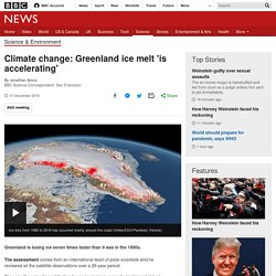
The assessment comes from an international team of polar scientists who've reviewed all the satellite observations over a 26-year period. They say Greenland's contribution to sea-level rise is currently tracking what had been regarded as a pessimistic projection of the future. The Mercator Map of the Arctic. Drawing Borders in the Arctic : The Race To Colonise the North. Drawing Borders in the Arctic: The Race To Colonise the North | The Market Mogul ▻
Antarctica - Sea to Sky. It's time to draw borders on the Arctic Ocean - Vox. In Antarctica, Two Crucial Glaciers Accelerate Toward the Sea. L’Arctique, vers un dégel des appétits géopolitiques ? Terminaux méthaniers, nouveaux forages, construction de voies ferrées et de navires brise-glace : ce serait depuis les années 20 la troisième course aux ressources naturelles au Nord du 66ème parallèle.
Ces ressources sont principalement des minerais rares et des réserves d’hydrocarbures : pour le seul gaz naturel, l’USGS américain estime que l’Arctique recèle 30 % des réserves mondiales. Cet appétit n’est pas qu’économique : avec la possibilité de l’ouverture prolongée par leur dégel des passages du Nord-Ouest (Canada) et du Nord-Est (Russie), l’Arctique revêt une dimension politique et stratégique plus appuyée : des revendications territoriales perdurent, la Russie plaide toujours pour une extension d’1,2 million de km² de son plateau continental et des eaux associées. .L’Arctique était le bout du monde. Le réchauffement climatique va-t-il le placer au centre des préoccupations géopolitiques ? Pétrole, gaz, terres rares, les convoitises sont nombreuses. 2017 Arctic Report Card : Arctic sea ice keeps getting younger and thinner.
2017 Arctic Report Card: Arctic sea ice keeps getting younger and thinner | NOAA Climate.gov▻ Despite the fact that the area of the Arctic Ocean covered by sea ice during the winter maximum has declined only slightly in recent decades, the ice itself is profoundly different than it used to be.
L'Arctique, un espace riche en hydrocarbures. Arctique : Les dessous géopolitiques de la protection de l'ours polaire — Géoconfluences. Take part in the discussion!
On Seenthis, you can recommend articles, comment, discuss with your friends, follow authors... Polar sea ice size of India vanishes in record heat Antarctica the sleeping elephant beginning to stir? Sea ice extent in Arctic and Antarctic reached record lows in November. Both the Arctic and Antarctic experienced record lows in sea ice extent in November, with scientists astonished to see Arctic ice actually retreating at a time when the region enters the cold darkness of winter.
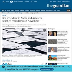
Warm temperatures and winds drove record declines in sea ice at both polar regions in November compared to the 38-year satellite record of ice extent for the month. Arctic sea ice extent averaged 9.08m sq km (3.51m sq miles) for November, which is 1.95m sq km (or 753,000 sq miles) below the long-term average from 1981 to 2010 for the month. Scientists at the National Snow and Ice Data Center (NSIDC) said that Arctic sea ice extent dipped for a short time in mid-November, an “almost unprecedented” event.
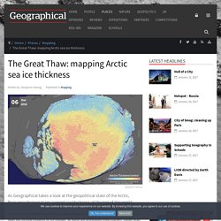
Sea ice shrank by around 50,000 sq km (19,300 sq miles) in this period, mainly in the Barents Sea. This decline, which also occurred to a smaller degree in November 2013, removed an area of ice larger than Denmark from the Arctic at a time when sea ice is usually growing. The Great Thaw: mapping Arctic sea ice thickness. As Geographical takes a look at the geopolitical state of the Arctic, Benjamin Hennig maps current ice thickness at the top of the world Sea ice can be described as frozen seawater floating on the surface of the polar oceans.
It does not include icebergs or ice shelves, as these are originating from glaciers, rather than sea water. Une gigantesque crevasse en Antarctique accélère la fonte de la calotte polaire. Arctic sea ice has undergone "fundamental changes" over the past three decades, the latest video from @NASA shows. Arctic sea ice: yet another record falls - ImaGeo. Nouvelles - Fonte anormale des glaces du Groenland - MétéoMédia. Take part in the discussion!
On Seenthis, you can recommend articles, comment, discuss with your friends, follow authors... Sign up, it’s free! RSS: Kassem tous les messages de Kassem Kassem @kassem Kassem @kassemCC BY-NC-SANouvelles - Fonte anormale des glaces du #Groenland - MétéoMédia▻ « Nous avons dû vérifier que nos modèles fonctionnaient toujours bien », a affirmé Peter Langen, climatologue de l’IMD. traduire avec Google#climaterasemodifyKassem @kassemCC BY-NC-SA ❝quote❞ (shift+tab)_italic_*bold* 5 Maps that Explain the Arctic @Fil_Scandinavie @ArcticRisks @klausdodds @marine_dcm @PlaneteVivante @FDerambure. La course aux ressources et aux territoires en Arctique. Right Relevance : Influencers, Articles and Conversations.
Yes, Mr. President, We Remade Our Atlas to Reflect Shrinking Ice. Unveiling his most aggressive plan yet to combat climate change, President Obama on Monday referenced recent dramatic changes that National Geographic made to its atlas because of melting sea ice. "Shrinking ice caps forced National Geographic to make the biggest change in its atlas since the Soviet Union broke apart," Obama said during a speech at the White House. (Watch a video of his speech.) He's right. ClimateCentral sur Twitter : "Two maps (and one bonus chart!) show Greenland's sudden, rapid meltdown: Paul Beckwith sur Twitter : "July 8th: Massive bite taken out of #Arctic sea-ice from very warm #oceans and air. #climate #climatechange #USA #NYC. Newsweek. With the ice in the Arctic melting, the region is in danger of becoming a 21st-century free-for-all for power and riches.
You’ve hit your limit of 5 free articles this month.Try our subscription options: Weekly home delivery with free shipping, access to Newsweek’s web site, and the complete online archive. Two Maps Show Greenland’s Sudden Melt Season Onset. Daily surface mass balance estimates of the Greenland ice sheet. Red indicates losses. Credit: Polar Portal It appears that Greenland’s melt season is making up for lost time. After a cool spring kept Greenland’s massive ice sheet mostly solid, a (comparatively) warm late June and early July have turned half the ice sheet’s surface into liquid, well outside the range of normal for this time of year. Right Relevance. In April of this year, two Dutch polar explorers, Marc Cornelissen and Philip de Roo, set off from Resolute Bay in the Canadian Arctic.
They were headed for Bathurst Island, a journey of 400km that was due to take around a month. This was part of the Last Ice Survey expedition to gather data about snow and ice thickness for York University, Ontario. They would walk and ski across a region known as the Last Ice Area, where summer sea ice is expected to be most resilient to climate change. A few days into their trip, when they were still in Resolute Bay preparing for the hard month ahead, Philip found Marc’s sled from a previous unsuccessful expedition being used by a local hunter. In one of the many short voice recordings which they uploaded each day during their journey, Marc talks about what a special feeling it is to be back in the region and how pleased he is to be there with his trusted expedition partner Philip.
I first met Marc and Philip in 2005. Businessinsider. Poles of Inaccessibility - the Remotest Places on Earth. Antarctica is the most remote continent, and due to its harsh climate and lack of any roads or trails, its POI may be considered as the most prominent of all POIs. The location of the POI of Antarctica is 54.9681° E and 83.6978° S, while the distance from this spot to the seashore is 1183.421 km. On top of holding the notion of having the hardest to reach POI, Antarctica is also a home to: South Pole the only spot on land that has no time zone assigned (does time stand still here?) ; South Magnetic Pole as the fast migrating pole, it actually moved out of the land of Antarctica and keeps wandering; Arctic Coastal Communities. Major Antarctic ice survey reveals dramatic melting - environment - 26 March 2015.
It's melting from above and below and crumbling at the edges. Antarctica is in trouble. Its frozen edges, or ice shelves, are disappearing into the ocean faster than we thought. Some have thinned by up to 18 per cent in the past two decades, and the process is accelerating. The most rapidly melting ones are likely to be gone within 100 years. Antarctica may have just set its highest temperature on record.
Antarctica, Earth's coldest, most barren continent, may have just set a remarkably unusual weather record. An Argentinian research station on the rapidly warming Antarctic Peninsula recorded a high temperature of 63.5 degrees Fahrenheit (17.5 degrees Celsius) on March 24, according to reports from Weather Underground. If this is investigated and verified by the World Meteorological Organization (WMO), it could become the highest temperature on record for the entire continent of Antarctica. The warmth at the Esperanza research station came one day after a nearly identical high temperature was logged at another Argentinean base, known as Base Marambio, also located along the Antarctic Peninsula.
Live The Crossing. Arctic sea ice gains can be seen on new government map of Canada.