
How are there no clouds on Google maps satellite view? - Quora. Golden Builders: Alchemists, Rosicrucians and the First Freemasons: Amazon.co.uk: Tobias Churton: 9781578633296: Books. Select Your Cookie Preferences We use cookies and similar tools that are necessary to enable you to make purchases, to enhance your shopping experiences and to provide our services, as detailed in our Cookie Notice.
We also use these cookies to understand how customers use our services (for example, by measuring site visits) so we can make improvements. Golden Builders: Alchemists, Rosicrucians and the First Freemasons: Amazon.co.uk: Tobias Churton: 9781578633296: Books. Select Your Cookie Preferences We use cookies and similar tools that are necessary to enable you to make purchases, to enhance your shopping experiences and to provide our services, as detailed in our Cookie Notice.
We also use these cookies to understand how customers use our services (for example, by measuring site visits) so we can make improvements. If you agree, we’ll also use cookies to complement your shopping experience across the Amazon stores as described in our Cookie Notice. This includes using first- and third-party cookies, which store or access standard device information such as a unique identifier. Golden Builders: Alchemists, Rosicrucians and the First Freemasons: Amazon.co.uk: Tobias Churton: 9781578633296: Books. Select Your Cookie Preferences We use cookies and similar tools that are necessary to enable you to make purchases, to enhance your shopping experiences and to provide our services, as detailed in our Cookie Notice.
We also use these cookies to understand how customers use our services (for example, by measuring site visits) so we can make improvements. If you agree, we’ll also use cookies to complement your shopping experience across the Amazon stores as described in our Cookie Notice. This includes using first- and third-party cookies, which store or access standard device information such as a unique identifier.
Third parties use cookies for their purposes of displaying and measuring personalised ads, generating audience insights, and developing and improving products. Sorry, there was a problem saving your cookie preferences. Chicago skyline visible from nearly 50 miles away in Indiana Dunes sunset. : interestingasfuck. 5m km difference between Perihelion & Aphelion 3.4% variance. NASA overt CGI of Earth, 'from Mars' This site may earn affiliate commissions from the links on this page.
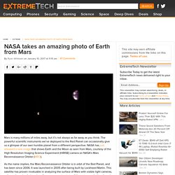
Terms of use. Mars is many millions of miles away, but it’s not always as far away as you think. The powerful scientific instruments we’ve deployed to the Red Planet can occasionally give us a glimpse of our own humble planet from a different perspective. NASA has just released a new image that shows Earth and the Moon as seen from Mars, courtesy of the High Resolution Imaging Science Experiment (HiRISE) camera on NASA’s Mars Reconnaissance Orbiter (MRO). As the name implies, the Mars Reconnaissance Orbiter is in orbit of the Red Planet, and has been since 2006. This newly released photo of our pale blue dot is a product of the satellite’s HiRISE camera, which is technically a telescope with a 0.5 meter reflecting mirror. HiRISE captures images in three wavelengths: infrared, red, and blue-green.
The careful processing of the two images into the one at the top of this article makes the details easier to see. The Occult Roots Of NASA And The Ongoing Fraud – Parsons, a Satanist, invents Rocketry. This post has been cobbled together from a number of places as the original Website is no longer available.
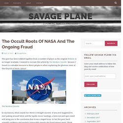
I wanted to recreate this article by The Modern Gnostic because I found it a valuable resource to direct people to when explaining the glorious roots of The Church of NASA. Enjoy! The Modern Gnostic In my lexicon, NASA stands for: Never A Straight Answer. If you ever happened to start poking around NASA and the Apollo moon landings, a keen eye and open mind will bring you to the conclusion that it was a staged hoax. Forbes desperately tries to debunk F.E. '5 Impossible Facts That Would Have To Be True If The Earth Were Flat' - ALL FAKE. From any one location on the surface of the Earth, it's impossible to tell what our planet's shape is.
Having a single vantage point, even with a clear horizon, allows you to see a handful of miles (or kilometers) in any direction, but that can only allow you to place constraints. The Earth could be flat, or spherical, or in hydrostatic equilibrium, or egg-shaped, or irregular, and you wouldn't know. Acedemia telling people the oblateness is trivial, too small to matter on photos. WHO discovered that the Earth is pear shaped, WHEN or HOW. Star Trek TNG. Jean Luc Picard. Researching Flat Earth, discoverer of oblate earth was Jean Felix Picard. The story of his 'discovery' is shrouded in Masonic symbolism. 13 triangles. Amiens. Jesuit. Jean-Félix Picard (21 July 1620 – 12 July 1682) was a French astronomer and priest born in La Flèche, where he studied at the Jesuit Collège Royal Henry-Le-Grand.
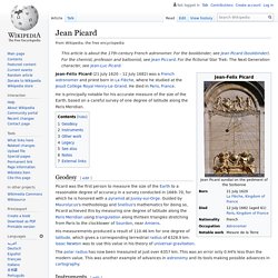
He died in Paris, France. He is principally notable for his accurate measure of the size of the Earth, based on a careful survey of one degree of latitude along the Paris Meridian. Geodesy[edit] Picard was the first person to measure the size of the Earth to a reasonable degree of accuracy in a survey conducted in 1669–70, for which he is honored with a pyramid at Juvisy-sur-Orge. Guided by Maurolycus's methodology and Snellius's mathematics for doing so, Picard achieved this by measuring one degree of latitude along the Paris Meridian using triangulation along thirteen triangles stretching from Paris to the clocktower of Sourdon, near Amiens. Earth is supposedly oblate, why arent Map Globes oblate. FE. Centrifugal force - not a force, science unable to explain how it works. Orlando Ferguson - famous Map, Square & Stationary Earth, 1893; I'd suggest he was an ex Mason who rebelled, map cites Bibles 4 corners of the Earth. Circle is an inversion of flat line. Sphere is inverted square. Theyre INVERTING the Biblical worldview.
Flat Earth map drawn by Orlando Ferguson in 1893.
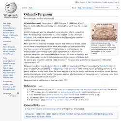
The map contains several references to biblical passages as well as various jabs at the "Globe Theory". Orlando Ferguson (November 6, 1846-February 3, 1911) was a South Dakota resident best known today for a detailed flat earth map he created in 1893. In 2011, Ferguson was the subject of press attention after a copy of his 1893 flat earth map was donated to, and accepted by, the Library of Congress. The Fall River Pioneer Museum in Hot Springs also retains a slightly-incomplete copy. More specifically, his map depicts a "square and stationary" Earth, based on his literal interpretation of the Bible, which references angels visiting the "four corners" of the world.[1][2] He lectured in Hot Springs on his theory in 1891, followed up by 60 page pamphlet full of theories.
Cutting Edge energy storage - massive flywheels - engineer says the angle the wheel is set at relative to Earths spin doesnt matter; literally 'earthquakes have more impact' Teutonic Knights. …the true history of the Templars is that they never went out of existence.
The main body went underground and according to esoteric records, many joined other Orders such as the Teutonic Knights and the Rosicrucians…they also became a successful banking fraternity. Later, in tandem with the Rosicrucian Order, they founded the Masonic Order to make the teachings accessible to the ‘common man’. The only significant group…left in Europe who were not…Christians by the year 1000AD were to be found in the Baltic and Eastern European regions. Roots of Nazi New Swabia - Duchy of Swabia descended from Tuetonic Knights. The Staufer, also known as the House of Staufen, or of Hohenstaufen (German: [ˌhoːənˈʃtaʊfən]), were a dynasty of German kings (1138–1254) during the Middle Ages.
Besides Germany, they also ruled the Kingdom of Sicily (1194–1268). In Italian historiography, they are known as the Svevi (Swabians), since they were (successive) dukes of Swabia from 1079. Three members of the dynasty—Frederick I, Henry VI and Frederick II—were crowned Holy Roman Emperor. Name[edit] The historical form of the name is Staufen. Southern Hemisphere - no GPS, no flight tracking, no direct flights.....public not allowed in Antarctica, absent on AE projection, S.H. continents shrunk on standard maps; S.H nations poor; Falklands Gov base, above Nazi New Swabia.
Azimuthal equidistant projection no Antarctica, 'used by ancient Egyptians in star maps'....used in U.N. emblem under a 33 sector grid & encircled by sheaves of wheat which also resemble goat of Mendes horns...Lucier & Isis Luciferia unified. Polar azimuthal equidistant projection Emblem of the United Nations containing a polar azimuthal equidistant projection. The azimuthal equidistant projection is an azimuthal map projection.
It has the useful properties that all points on the map are at proportionally correct distances from the center point, and that all points on the map are at the correct azimuth (direction) from the center point. A useful application for this type of projection is a polar projection which shows all meridians (lines of longitude) as straight, with distances from the pole represented correctly. The flag of the United Nations contains an example of a polar azimuthal equidistant projection. Curvature 'inversely proportional' to the square of the mile; the mile is 666; its about inversion and usurping God. Highest freefall...28000 feet, plane altitude, yet they use a fisheye lense to make Earth appear spherical as if in high orbit...bizarre, not just an accident. A man falling from space to the Earth surface: Live telecast by NASA.
Space X horizontal rocket caught out by atmospheric conditions, look how media tilt the photo, see the tree. Why Doesn't The Vacuum Of Space Suck Up Earth's Atmosphere? Answer given uses straw man, cognitive scotoma. AMELIA EARHART- THE SECRET SHE KNEW. Notes. Arago Rose Line N/S reversed. Schools, Courts, Churches and the Cult of Saturn. Philip Stallings: The Biblical Flat Earth: Hidden In Plain Sight. How many of you have carefully looked at and studied the U.N. flag?
It is quite an interesting flag indeed. In fact, what you probably didn't know is that it uses the flat earth map as its depiction of earth. Here is Gleason's flat earth map from 1892: Ever notice what is missing in the U.N. flag? Lloyd Pye Our World Maps Are Wrong.