
Using MySQL and PHP with Google Maps Overview This tutorial shows you how to display information from a MySQL database on a Google Map using the Maps JavaScript API.
It suits people with intermediate knowledge of MySQL, PHP and XML. The map in this tutorial displays two kinds of markers to differentiate between the location of restaurants and bars respectively. A database in MySQL stores information about the individual marker locations like the type of place (whether it's a restaurant or a bar), its name, address and geographic coordinates.
The map retrieves this information from the database, through an XML file that acts as an intermediary between the database and the map. Click a marker on the map below to display an info window with the location name and address. The sample below shows the entire code you need to create this map. Try it yourself You can experiment with this code in JSFiddle by clicking the <> icon in the top-right corner of the code window. Getting started Creating a table in MySQL Populating the table. Batch geocode. MapHub. Custom Topographic Maps and Aerial Maps for the USA & Canada. Best Online Mapping Tools for Web Developers. There’s nothing quite like a good, useful map.
Today, using online maps is an easy and engaging process. Making your own online maps is not a big undertaking anymore; we have at our disposal a wide range of available online mapping tools, from free and simple, to feature rich and complex to use. For web developers not familiar with web mapping, the agony of choice might be intimidating. You want to make maps, but don’t know where to start nor which tools to use. I am here to help with this list of the best mapping tools.
A Little Bit of History From its beginning, technology has had an influence on mapmaking and how maps are used. Mapping in the past. Argo-geo. Rapid reverse-geocoding using Mapzen Search Rapid reverse-geocoding using Mapzen Search Installation.
Products · Mapzen. Rooftop Geocoding - Go Data. Rooftop geocoding is a simple, powerful process.
Once you upload your list, you’ll be asked to identify the location of the address fields using our intuitive point and click interface. Once you check out, we’ll begin appending all the key information to your file and have it back to you in just a few minutes. The process starts by standardizing your addresses before adding on latitude, longitude, and other useful data. We return key data that falls into three categories: Standardized Address – The address elements of your record (address, city, state, and zip) are appended alongside your original data. Latitude and Longitude – Each of your records gets appended with a rooftop, or delivery point, level latitude and longitude precise enough to identify the exact location of the address. Untitled. Mapzen · an open, sustainable, and accessible mapping platform.
OpenAddresses. Maptitude Pricing and Ordering. Call Caliper at +1 617-527-4700 to place your order, download the Maptitude order form and fax it to +1 617-527-5113, or use the Caliper Store.
Each Maptitude licence can be installed and activated on a single computer. This includes the desktop/remote/concurrent/cloud licenses. Caliper provides a comprehensive program of technical support, training, and consulting services to ensure the success of your Maptitude applications. Announcing Spam, a D3 library to create maps with Canvas — newsapps io. Solar Mapping Resources. Choosing solar energy is a big investment.
In order to help consumers quantify the potential benefits, national laboratories and private companies have developed a number of tools to forecast their solar futures. Satellite maps, irradiance data, and real-time bids from installers have been combined to assist customers in understanding the potential costs and benefits of solar with just the click of a button. The examples below help consumers start the process of choosing solar by demonstrating the solar potential of their homes or businesses. Energy Sage Energy Sage, another SunShot Incubator awardee, allows homeowners, businesses, or nonprofit organizations to estimate their energy savings from solar, and connects them with prescreened installers who can provide estimates specific to the user’s address. The Traveling Salesman with Simulated Annealing, R, and Shiny - Todd W. Schneider.
I built an interactive Shiny application that uses simulated annealing to solve the famous traveling salesman problem.
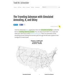
You can play around with it to create and solve your own tours at the bottom of this post. Here's an animation of the annealing process finding the shortest path through the 48 state capitals of the contiguous United States: How does the simulated annealing process work? We start by picking an arbitrary initial tour from the set of all valid tours. GmapGIS: Web application to draw on Google maps; Create, share,link,embed and publish interactive maps with polygons, lines, circles, markers and labels.
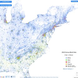
Mapstarter. The Racial Dot Map: One Dot Per Person for the Entire U.S. Terms of Use.
State ZIP Code Maps - ZIP Code Maps - Maponics Online Store. State ZIP Code Maps The specifications below describe the maps you would receive.
We believe you should know exactly what to expect when you order a map from Maponics. A sample of this type of map is available on this page. OpenCage Geocoder - API docs. QGIS Python Plugins Repository. Journey to the open data jungle with OpenRefine, CartoDB, Leaflet and Javascript. Playing around with data is not an easy task.
There’s no secret formula for successfully finding your way through a bunch of pdf, csv, excel, APIs or whatever else you might have to deal with. There’s not even a single tool that could help you through the whole process, on the contrary, you’ll have to spend some time learning and trying out different techniques. The good news, is that the tools available are pretty awesome, and they are getting even more awesome day by day. In this series of articles we will take a look at a couple of really mind-blowing tools. Zip Code Shapefiles - US DataMart. Our ZIP Code boundary definitions are refreshed quarterly with current US Postal Service definitions and reflect current US Postal ZIP Code definitions. You can also download a free ZIP Code sample Shapefile package covering the Chicago, IL market.
Download Free Sample Data HereZIP Code Boundaries for the Chicago, IL region: Our ZIP Code Shapefile datasets are ready to be integrated with your own GIS tools. The download link to our Shapefile data will be immediately sent to your email address as provided during checkout. Just let us know <here> if you need FTP or other special handling. Geopointe Pricing. Geopointe supports any Salesforce license type (CRM, Platform, etc) and runs on every Edition that allows for AppExchange installs. When subscribing to Geopointe, users must subscribe to the “core” offering. Map Stack by Stamen. Map Stack: Maps for all. Jun 12, 2013 Map Stack: Maps for all Good-looking maps used to be the domain of experts. That’s been changing quite a bit in the last few years, and it’s easier than ever now for developers to access mapping data (the recent State of the Map US conference was a great place to hear about this).
Never content to leave well enough alone, we thought we’d kick this sideways a bit and make it easy for the rest of us to make some great stuff. Dynamic Maps, GIS Data, and Analysis Tools - Data Resources. NREL's Geospatial Data Science Team develops technology-specific GIS data maps for a variety of areas, as well as targeted analysis tools that can help determine availability of renewable energy resources. Geographic Information System Data NREL's Geospatial Data Science Team develops technology-specific GIS data maps for a variety of areas, including biomass, geothermal, solar, wind, and renewable hydrogen. The team has made some of our datasets available for download through this Web site. 10km and 40km solar datasets are available for the United States and some international sites. 50m wind datasets are available for specific states, regions and some international sites. 25km wind datasets are available for the United States. 90m offshore wind datasets are available for the United States offshore areas.
Note: These datasets are designed to be used in GIS software applications. Carto - MAP - SIG. Geojson.io. 11 Helpful jQuery Google Maps Plugins and Tutorials. jQuery Google maps are very easy to use technique and popular among the users to locate a specific location on the world map. Which can easily be done using some of jQuery Google Maps plugins. Pedro's Tech Mumblings: Bing Maps and HTML5 (Part 4 - Final optimization) In Part 3 of this "Bing Maps and HTML5" series I optimized the drawing of the Canvas quite a bit. The time taken to draw the canvas with 140.000 points was cut from 800ms to 75ms. Anyway, and as I said previously, my target was (and is) the 40ms mark (1000/25) for a full canvas render with all the points. Displaying WebGL data on Google Maps. Geocoding Web Service - MapQuest Platform. MapQuest Geocoding Plugin for Leaflet v1.0 - MapQuest Developer Network. The Geocoding plugin makes it easy to create a geocode request using the MapQuest Geocoding Web Service.
Getting Started To begin using the MapQuest Geocoding Plugin for Leaflet, add the following to the head section of your page. MapQuest Developer Network: Map APIs, SDKs and Web Services - MapQuest Developer Network. Geocoder - HERE Developers. List of geocoding systems. jQuery Geo docs. USA States. Mapping America — Census Bureau 2005-9 American Community Survey.
Maps, Lies and Storytelling. JavaScript APIs - HERE Developers. Voter Gravity Features - Voter Gravity. Map Making Software at Map Business Online. Using custom map data with DataMaps. Bl.ocks.org - markmarkoh. Site Title. Geotargeting/ Datamaps/README.md at master · markmarkoh/datamaps. DataMaps. Mapshaper. Compare CensusViewer Versions – Free, Basic and Premium. Serpentine-Edge Map Marathon Gallery. Bounding Box Tool: Metadata Enrichment for Catalogue Records by Visually Selecting Geographic Coordinates (Latitude / Longitude) for Maps. RouteXL - Snazzy Maps - Free Styles for Google Maps.
US Map - Counties - Data Visualization with D3.js. Excel Geocoding Tool by maxrice. Geocoder.us: a free US address geocoder. The Google Geocoding API - Google Maps API Web Services. Batch Geocode. List of Online Geocoding Systems. Create Key - Bing Maps Account Center. Free Online Database Geocoding - Step 3 Identify Data Fields. Account Details - Bing Maps Account Center. QGIS, TileMill and MapBox, oh my. Or, web mapping tools I am learning to use. Boundless, formerly OpenGeo. Leaflet Map with a marker. Toni Uebernickel : GeoJSON MultiPolygon to Google Maps Polygon. Tile Drawer.
Converting shapefiles to TopoJSON + a GitHub secret. City.stamen.com/digital_city/02/20090609/ Dotspotting - Welcome! Creating a Store Locator with PHP, MySQL & Google Maps - Google Maps API. Mapbox/map-site at jekyll. Energy Maps. CartoDB Example. Electricity_Price_Map.jpg (3300×2550) Maps. Projects. Foreign Owned US National Debt. GeoCommons. Open Source Tool Sets for Creating High-density Maps. Open Source Tool Sets for Creating High-density Maps. Opportunity Nation - The Opportunity Index measures 16 key indicators to produce an overall opportunity score and grade for all 50 states, Washington DC & over 2,900 counties.
Mapping Opportunity in the United States. GeoCommons. Mapping geoJSON files on GitHub. Global Forest Watch. Crowdsourced Architectural Salvage. Crowdsourced Architectural Salvage. Notebook and portfolio of Sheraz Khan. File:2012 12 14 Electricity Price-01.jpg. Cartografika. Chicago Health Atlas Data Feeds. Smartchicago/chicago-atlas. Browse by neighborhood - Chicago Health Atlas. Showcase. A clean point of interest icon set from MapBox. What is my zip code? Share your location - Longitude.me.