
Mapzone.ordnancesurvey.co.uk/mapzone/PagesHomeworkHelp/docs/easypeasy.pdf. Mapzone.ordnancesurvey.co.uk/mapzone/PagesHomeworkHelp/docs/mapabilitycompassbearings.pdf. Mapzone.ordnancesurvey.co.uk/mapzone/PagesHomeworkHelp/docs/mapabilityreliefandcontourlines.pdf. Mapzone.ordnancesurvey.co.uk/mapzone/PagesHomeworkHelp/docs/mapabilitymeasuringdistance.pdf. Mapzone.ordnancesurvey.co.uk/mapzone/PagesHomeworkHelp/docs/mapabilityunderstandingscale.pdf. Mapzone.ordnancesurvey.co.uk/mapzone/PagesHomeworkHelp/docs/mapabilitygridreferences.pdf.
The Weather - Sounds, Pictures, Blogs and Poetry. Bingo_cards. Weather_bingo (1) Year 6 The Sea and Coasts. Dorset_photos-lap. Intro_to_coasts_ppt. Seaside_poems. Coast_photos. Coast_paintings. Year 6 Water, Rivers and Lakes. Rivers are Largest Source Of Mercury in Arctic Ocean, Study Says. The_life_of_a_river. Year 6 Italy. Physical, Population and the Economy. Geography of Italy. Geography of Italy.
Coordinates: Italy viewed from space Italy is located in southern Europe and comprises the long, boot-shaped Italian Peninsula, the southern side of Alps, the large plain of Po Valley and some islands including Sicily and Sardinia.
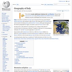
Corsica, although belonging to the Italian geographical region, has been a part of France since 1769. Its total area is 301,340 km2 (116,350 sq mi), of which 294,140 km2 (113,570 sq mi) is land and 7,200 km2 is water (2,780 sq mi). Climate. List of national parks of Italy. The Italian national parks cover about five percent of the country.
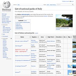
The parks are managed by the Ministry of the Environment (Italian: Ministero dell'Ambiente).[1] List of Italian national parks[edit] See also[edit] References[edit] Environment. List of regional parks of Italy. The Regional parks of Italy include areas of land, sea, rivers and their banks, lakes and their environs, which have environmental or naturalistic importance and are often valued for their landscape features and for representing particular local traditions.
They are officially regulated by Presidential Decree D.P.R. 616/77, which transferred the responsibility for their upkeep to the Italian regions. The fifth edition of the EUAP (2003) comprises 105 officially designated Regional parks, covering a total land area of some 12,000 square kilometres. Demographics of Italy. Economy of Italy. Culture of Italy.
Central Europe. Eastern Europe. Recovered Territories and Regions of Western Europe. Territories and Regions of Eastern Europe. Year 6 Scandinavia. Why Scandinavia can teach us a thing or two about surviving a recession. High numbers of Swedes are employed in the public sector, such as this nurse in a Stockholm hospital.

Photograph: Graham Turner According to liberal thinkers, Scandinavian countries should have drowned in the current economic crisis with their bloated public sectors and a nanny-state mentality that stifles individual creativity. But the opposite has happened. School. Norway in a nutshell® - Official site.
Free Map Tools. OS symbol worksheet. OS symbol worksheet. Mapzone.ordnancesurvey.co.uk/mapzone/docs/25kenglishlegend08.pdf. World Map with Countries. SHOW®/WORLD - A New Way To Look At The World. 3D Maps, Coordinates and Bingo. Interactive world, Maps of the continents, World Anthems, Pictures and Information. MapZone - Homework Help - Maptivity. Oxfam - Mapping Our World: Lesson 1 - Globe Unwrapped. GCSE Geography: Population, Employment and Ecosystems.