
Overview of the galaxy. Note: This page is a draft (October 2014), incomplete sections are flagged: [DRAFT].
This page outlines the features and structures of the Galaxy as they are conceived by modern astronomy: a single, gravitationally bound system of enormous mass, energy and dimensions. The presentation begins and concludes with the Milky Way, the Galaxy as it appears to the naked eye from our location near the Sun. Many basic research papers are linked from Further Reading at the bottom of this page, with instructions on how to find papers of interest online. From the Milky Way to the Galaxy To the naked eye, our Galaxy appears as the Milky Way: an irregular, unevenly luminous band of dim light.
The Naked Eye Era. "It is easily seen that the Milky Way is not simply a circle but a zone having quite the color of milk, whence its name; and that it is not regular and ordered, but different in width, color, density, and position; and that in one part it is double.
Time Line of Space Exploration. The new page address is working now!!
==> www.rocketmime.com/space/timeline.html October 4, 1957 - Sputnik 1, the first man-made object to orbit the Earth, is launched by the U.S.S.R., and remains in orbit until January 4, 1958.November 3, 1957 - Sputnik 2, carrying the dog Laika for 7 days in orbit, is launched by the U.S.S.R., and remains in orbit until April 13, 1958. January 31, 1958 - Explorer 1, the first U.S. satellite in orbit, lifts off at Cape Canaveral using a modified ABMA-JPL Jupiter-C rocket. It carries a scientific experiment of James A. Real Time Data. NOAA / NWS Space Weather Prediction Center. Sx_101_Resources.pdf. Colonization of the outer Solar System.
Many parts of the outer Solar System have been considered for possible future colonization.
Most of the larger moons of the outer planets contain water ice, liquid water, and organic compounds that might be useful for sustaining human life.[1][2] Colonies in the outer Solar System could also serve as centers for long-term investigation of the planet and the other moons. In particular, robotic devices could be controlled by humans without the very long time delays needed to communicate with Earth. There have also been proposals to place robotic aerostats in the upper atmospheres of the Solar System's gas giant planets for exploration and possibly mining of helium-3, which could have a very high value per unit mass as a thermonuclear fuel.[3][4] Cars, SUVs & Crossover Vehicles. Anomalie magnétique de l'Atlantique sud. Un article de Wikipédia, l'encyclopédie libre.
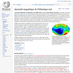
L'anomalie magnétique de l'Atlantique sud, AMAS, SAA en anglais (South Atlantic Anomaly) est la région où la partie interne de la ceinture de Van Allen est la plus proche de la surface de la Terre. Les lobes de la ceinture de Van Allen sont disposés symétriquement par rapport à l'axe du magnétisme terrestre, qui est décalé d'environ 11 ° par rapport à l'axe de rotation de la Terre. On the way to quantum-based satellite communication. Premier vol du démonstrateur Eole - un drone lanceur de satellites - GLOBAL UAV sur Viadeo.com. Lancer des fusées dans l’espace, un rêve de gosse, mais un rêve qui coûte cher.
Geospatial intelligence. Geospatial intelligence, GEOINT (GEOspatial INTelligence), GeoIntel (Geospatial Intelligence), or GSI (GeoSpatial Intelligence) is intelligence about the human activity on earth derived from the exploitation and analysis of imagery and geospatial information that describes, assesses, and visually depicts physical features and geographically referenced activities on the Earth.
GEOINT consists of imagery, imagery intelligence (IMINT) and geospatial information.[1] Amplified definition[edit] GEOINT encompasses all aspects of imagery (including capabilities formerly referred to as Advanced Geospatial Intelligence and imagery-derived MASINT) and geospatial information and services (GI&S); formerly referred to as mapping, charting, and geodesy). Geospatial data, information, and knowledge[edit] Relationship to other "INTs"[edit] Other factors[edit]
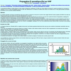
Les puissances spatiales. Propagation E sporadique (Es) sur VHF. Propagation E sporadique (Es) sur VHFRetour au menu : La propagation - Index général Voir aussi : l'ionosphère - Phénomènes d'optique et propagation des ondes - hauteur virtuelle - fréquence critique - Conditions de la réflexion d'une onde dans une couche ionosphérique - Les modes de propagation ionosphérique - Le trafic via E-sporadique sur 144 MHz - La possibilité de trafiquer à longue distance sur des ondes de fréquences supérieures à 30 MHz est connue depuis les années 30, quand les amateurs ont commencé à s'équiper sur VHF.
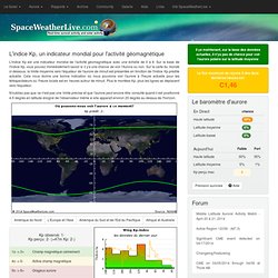
L'indice Kp, un indicateur mondial pour l'activité géomagnétique. L'indice Kp, un indicateur mondial pour l'activité géomagnétique.
Future spacecraft could use dead stars to navigate. The European Space Agency (ESA) wants to know if it’s possible to use dead stars as a navigational aid for traveling in deep space.
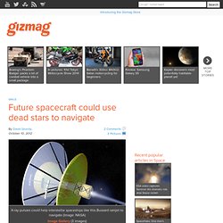
To answer that question, ESA has contracted Britain’s National Physical Laboratory (NPL) and the University of Leicester to investigate whether pulsars can serve as navigational beacons in the far-flung reaches of the outer Solar System or interstellar space. With GPS, smartphones and online maps, navigation has become so simple that we hardly give it a thought anymore – unless a software glitch has the satnav telling us to drive into a lake. For probes heading into deep space, it’s another matter.
Currently, spacecraft are guided by radio signals from ground stations on Earth or other spacecraft, but the farther out one goes, the less reliable radio signals become. Radio beams can take hours within the Solar System and days, months or years outside of it. Géocaching. Un article de Wikipédia, l'encyclopédie libre.
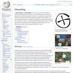
L'un des symboles les plus utilisés pour le Geocaching Le contenu d'une « géocache » en Allemagne. Le géocaching (ou geocaching) est un loisir qui consiste à utiliser la technique du géopositionnement par satellite (GPS) pour rechercher ou dissimuler un contenant (appelé « cache » ou « géocache ») dans divers endroits à travers le monde.
Une géocache typique est constituée d’un petit contenant étanche et résistant comprenant un registre des visites et un ou plusieurs « trésors », généralement des bibelots sans valeur. Plus de deux millions de géocaches sont répertoriées dans 222 pays sur les différents sites web communautaires dédiés à ce loisir. Intelligence Resource Program. Astrium and EADS Innovation Works Partner with Dassault Systmes to Design the Future of Space Vehicles. Dassault Systmes (Euronext Paris: #13065, DSY.PA), a world leader in 3D and Product Lifecycle Management (PLM) solutions, announced today a joint project with Astrium, Europes number one space company, and EADS Innovation Works, the corporate research and technology network of EADS, to develop solutions based on Dassault Systmes Version 6 platform that will enable to improve Astriums and EADS internal engineering methods, through the use of an innovative and revolutionary concept: the functional digital mockup (FDMU).
The FDMU, unlike a digital mockup, which is associated more to the 3D geometry of a vehicle, will play an essential role during the exploration design phase. Based on Dassault Systmes RFLP (Requirements, Functional, Logical, and Physical) concept, it will add a whole new dimension to multi-disciplinary collaboration at various stages of development, using CATIA, ENOVIA and SIMULIA. Military satellites market growth suffers from budgetary challenges. Back to News Friday 25 January 2013, Amsterdam In 2012 the global military satellite market valued US$11.8 billion and is expected to value US$17.3 billion by 2022, representing a CAGR of 3.9% during the forecast period.
A lire: Théorie de développement. Visions2200/HomePrime. Technology and Innovation. SSI - Publications. Technologie. Production d'énergie. Yasuyuki Fukumuro, Practical Application of Space-Based Solar Power Generation. TOP > Interviews > Yasuyuki Fukumuro, Practical Application of Space-Based Solar Power Generation Q. Could you explain the Space Solar Power Systems project. Laser beam-type SSPS The Space Solar Power Systems project is a space-based solar power plant that generates energy by collecting sunlight in geostationary orbit.
Amalthee. Point de Lagrange. Communications. Microsoft Word - AAP-6_2008_1.doc - nato2008.pdf. Microwave Encyclopedia - MicroWaves101.com. Arms Control. Armement Politique. Livre blanc sur la défense et la sécurité nationale. A la veille des cérémonies du 14 juillet 2012, le président de la République a annoncé sa décision de lancer la préparation d'un nouveau Livre blanc sur la défense et la sécurité nationale. L'objectif est de définir la stratégie nationale et les capacités nécessaires dans les quinze à vingt ans à venir en matière de défense et de sécurité pour répondre aux multiples défis auxquels nous sommes confrontés dans un monde particulièrement instable.
Il a créé dans ce but une "commission du Livre blanc sur la défense et la sécurité nationale" et en a confié la présidence à M. Jean-Marie Guéhenno, Conseiller maître à la Cour des comptes. La commission achèvera ses travaux à la fin de l’année 2012. Photo : Dicod La commission du Livre blanc sur la défense et la sécurité nationale Le président de la République a fixé le mandat de la commission du Livre blanc dans la lettre qu'il a adressée à M.
Earth. Atmosphère, composition. Atmosphere composition diagram. Travail d'Etude et de Recherche - L'environnement terrestre, les rayonnements cosmiques et leurs interactions. L'environnement terrestre, les rayonnements cosmiques et leurs interactions Cet exposé a été réalisé de Mai à Juin 1996 à l'IUP GSI de Clermont-Ferrand par David BERNARD, Xavier DUMONCEAU et Vincent LAFON.
Le but était de synthétiser en une trentaine de pages l'état des connaissances et des recherches sur un sujet donné : l'environnement terrestre, les rayonnements cosmiques et leurs interactions. Vous pouvez télécharger la version Adobe Acrobat de ce TER (attention : 1,13Mo) : ter.PDF Le titre est vaste, mais il impose une approche pluridisciplinaire. The Thermosphere. This is an image of the space shuttle as it is orbiting around the Earth.
The space shuttle orbits in the thermosphere of the Earth. Click on image for full size Courtesy of NASA. Des flux de particules. Qu’est-ce que le vent solaire ? Liens PLASMAS. Accueil > Erreur 404 Erreur 404.
Relevé Géographique. Earth Fact Sheet. Bulk parameters Mass (1024 kg) 5.9726 Volume (1010 km3) 108.321 Equatorial radius (km) 6378.1 Polar radius (km) 6356.8 Volumetric mean radius (km) 6371.0 Core radius (km) 3485 Ellipticity (Flattening) 0.00335 Mean density (kg/m3) 5514 Surface gravity (m/s2) 9.798 Surface acceleration (m/s2) 9.780 Escape velocity (km/s) 11.186 GM (x 106 km3/s2) 0.3986 Bond albedo 0.306 Visual geometric albedo 0.367 Visual magnitude V(1,0) -3.86 Solar irradiance (W/m2) 1367.6 Black-body temperature (K) 254.3 Topographic range (km) 20 Moment of inertia (I/MR2) 0.3308 J2 (x 10-6) 1082.63 Number of natural satellites 1 Planetary ring system No Orbital parameters.
Mars Fact Sheet. Bulk parameters Mars Earth Ratio (Mars/Earth) Mass (1024 kg) 0.64171 5.9724 0.107 Volume (1010 km3) 16.318 108.321 0.151 Equatorial radius (km) 3396.2 6378.1 0.532 Polar radius (km) 3376.2 6356.8 0.531 Volumetric mean radius (km) 3389.5 6371.0 0.532 Core radius (km) 1700 3485 0.488 Ellipticity (Flattening) 0.00589 0.00335 1.76 Mean density (kg/m3) 3933 5514 0.713 Surface gravity (m/s2) 3.71 9.80 0.379 Surface acceleration (m/s2) 3.69 9.78 0.377 Escape velocity (km/s) 5.03 11.19 0.450 GM (x 106 km3/s2) 0.042828 0.39860 0.107 Bond albedo 0.250 0.306 0.817 Visual geometric albedo 0.170 0.367 0.463 Visual magnitude V(1,0) -1.52 -3.86 - Solar irradiance (W/m2) 586.2 1361.0 0.431 Black-body temperature (K) 209.8 254.0 0.826 Topographic range (km) 30 20 1.500 Moment of inertia (I/MR2) 0.366 0.3308 1.106 J2 (x 10-6) 1960.45 1082.63 1.811 Number of natural satellites 2 1 Planetary ring system No No Orbital parameters Mars Observational Parameters Mars Mean Orbital Elements (J2000)
Moon Fact Sheet. Bulk parameters. Orbital Debris Technical Library. NASA Orbital Debris Program Office. Environnement Terre. Depuis 1957, il y a eu plus de 4600 lancements plus de 200 explosions en orbite qui ont généré : Répartition des débris > 10cm par type : Il est intéressant de connaître les zones d'évolution des débris spatiaux catalogués à des fins d'analyse mission ainsi que leur évolution au cours du temps. Cette connaissance peut se traduire, par exemple, par la densité d'objets spatiaux par altitude.
Ce graphique montre également les zones d'intérêt pour les applications ou missions spatiales, c'est à dire les orbites basses (altitude inférieure à 2000km), les orbites moyennes dites MEO (altitude autour de 20 000 km), les orbites géostationnaire et géosynchrones.
Débris. Catalogue. Le cas de l'orbite géostationnaire. Au 1er janvier 2009, on dénombrait 1186 objets de plus d'1 m sur l'orbite géostationnaire et dans son environnement immédiat. Parmi eux, 381 seulement sont des satellites opérationnels. The 1945 Proposal by Arthur C. Clarke for Geostationary Satellite Communications. Sir Arthur C. Clarke's most famous prediction on the future is his proposal of geostationary satellite communications published in the Wireless World magazine in 1945. Not considered seriously at the time it became a reality within 20 years with the launching on 1965 April 6th of Intelsat I Early Bird the first commercial geostationary communication satellite. A satellite in an equatorial circular orbit at a distance of approximately 42,164 km from the center of the Earth, i.e., approximately 35,787 km (22,237 miles) above mean sea level has a period equal to the Earth's rotation on its axis (Sidereal Day=23h56m) and would remain geostationary over the same point on the Earth's equator.
AERO_Rapport_final_636_addendum.pdf. Missions spatiales. Big LEO tables - overview.
Astronomie. Solar and Heliospheric Observatory Homepage. Société d´Astronomie de Rennes. Organisme. Civil. The Boeing Company: Defense, Space & Security. BDS - Satellites & Space. Defense Advanced Research Projects Agency. North American Aerospace Defense Command. CESA Centre d’études stratégiques aérospatiales. RSSD - Research Science Home Page. Astronomy & Astrophysics (A&A) Windows to the Universe. Planet-Terre : ressources en géologie / sciences de la Terre - Ressources scientifiques pour l'enseignement.