
Pic4Carto. Efficient picture viewer for high-level of detail mapping Start now Just select an area on the map (zoom in to see the grid) Why all this ?

There are plenty open street-level pictures on the web (Mapillary, Flickr, Wikimedia Commons...). All of them have their own viewer. Want to know more ? Checkout the repository. Zoom in to select area. Un référentiel national ouvert : de l'adresse à la coordonnée géographique - adresse.data.gouv.fr. OSM-Pilot OpenStationMap. OpenTripPlanner. BigMap. OpenLevelUp! OSM Buildings. Leaflet | © OpenStreetMap contributors, Map tiles © MapBox, © OSM Buildings.

The API to build cool stuff with public transport. MapRoulette. Cartoparties OpenStreetMap : quelques outils de terrain. Animals Google Maps icons. Chimère. Medical by OpenStreetMap. Da es vorerst zwei unterschiedliche Tags gibt werden beide ausgewertet und unterschiedlich dargestellt.

Defibrillator (medical) Defibrillator (emergency:aed) Defibrillator (emergency) Wiki: Proposed_features Qualitätsverbesserung Tag-Analyse Mit dem Mausrad oder der Zoombar links kann die Karte vergrößert oder verkleinert werden. Durch Festhalten und ziehen mit der Maus,lässt sich die Karte verschieben. Die in der Legende beschriebenen Objekte werden durch zusätzliche Marker auf der Karte angezeigt. Auf der rechten Seite finden Sie blaue Laschen .
Fehler in der Kartengrundlage, wie auch den eingeblendeten Daten, kann JEDER melden. Klicken Sie hier um die OSMB-Karte mit dem aktuellen Kartenausschnitt zu öffnen. Weitere Informationen zu OSMB finden Sie im OSM-Wiki. Sollten Sie Fehler in meiner Darstellung finden, dann schicken Sie mir zur Objektbeschreibung bitte nach Möglichkeit die zugehörige OSM-ID. Geofabrik Tools. Installer un serveur cartographique avec OpenStreetMap - Syrinxoon Tuts. Building a tile server from packages. If you’d like to build your own tile server, using packages can save you a good deal of installation work.
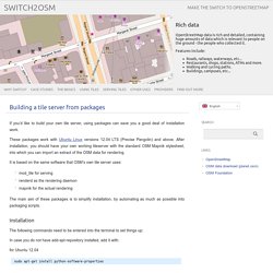
These packages work with Ubuntu Linux versions 12.04 LTS (Precise Pangolin) and above. After installation, you should have your own working tileserver with the standard OSM Mapnik stylesheet, into which you can import an extract of the OSM data for rendering. It is based on the same software that OSM’s own tile server uses: mod_tile for servingrenderd as the rendering daemonmapnik for the actual rendering The main aim of these packages is to simplify installation, by automating as much as possible into packaging scripts.
Installation The following commands need to be entered into the terminal to set things up: In case you do not have add-apt-repository installed, add it with: for Ubuntu 12.04. BrainCrunch - Maperitive Tutorial: Generating OSM Map For Adobe Illustrator In Seven Easy Steps. OsmOse - carte. You must be logged in order to use the tag editor Login no bubbles at this zoom factor.

Walking Papers. Quantum GIS. JOSM/Guide. Welcome to the JOSM guide.
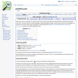
This guide is split across several tabs (above), starting with an introduction aimed at new users. The text assumes some knowledge of OpenStreetMap concepts, and focusses entirely on using JOSM, not other tools. As such, some users may prefer to read the general Beginners' Guide or the Potlatch 2/Primer or learnosm.org (which also offers JOSM tutorials). Starting JOSM Step 1: Download a jar file : josm-tested.jar Step 2: Double-click on the jar file Step 3: There is no step 3! Don't like jar files? For operating system specific installation steps or troubleshooting tips see JOSM/Installation When JOSM starts up, the main editing space displays some text. Download data Click the download toolbar button ( ) to open the download dialog window.
Initially the 'slippy map' tab is selected. Finally use the left mouse button to drag a box around the area you want to download. When you click 'OK', the data should appear in the main editing area. OpenLayers: Home. Cartes de France pour GPS Garmin. Pourquoi la carte n'est-elle pas complète ?
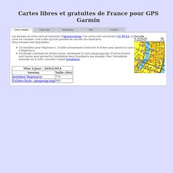
Cette carte est basée sur les données OpenStreetMap. Le projet n'existant que depuis 2004, de nombreuses données manquent encore. Cependant, la progression est rapide et la majorité des grandes villes est déjà très bien couverte. Vous pouvez bien sûr contribuer pour ajouter des données, en regardant la section en-dessous. Comment améliorer la carte ? En participant à OpenStreetMap ! Vous pouvez envoyer toutes vos traces GPS sur Openstreetmap et tracer ainsi les chemins ou routes que vous avez déjà parcourus.pour la documentation, vous pouvez regarder le wiki Openstreetmap.
La recherche de rue devrait normalement fonctionner, si la rue est présente sur la carte bien sur. Cependant, la carte est divisée en une centaine de morceaux, et la recherche d'adresse n'est possible que dans le morceau pris en référence par le GPS, par défaut celui dans lequel vous êtes. Vous pouvez trouver d'autres cartes sur cette page. Layers.openstreetmap.fr - Tuiles pour contrôle de données / Tile service with data checks.
© Openstreetmap France | Données © les contributeurs OpenStreetMap, Calque © sly Base Layer Overlays Serveur et hébergement donné par la Fondation d'Entreprise Free A propos de ce service / What is this Base mise à jour le jeudi 10 avril 2014 00:17:01 UTC.

Developpement d'une interface de génération des fichiers d'import du cadastre.