
ArcGIS Resources. Maps and Data Oregon/Washington BLM. Welcome to the Maps and Data page.
We hope you will take the time to explore it. The page contains links to maps, Cadastral Survey, and Land Records. We provide leadership, management, and technical direction for the development and implementation of the BLM Oregon and Washington’s surveying, mapping, aerial photography, geodesy, resource grade global positioning system (GPS) activities. If you can't find what you're looking for on this site, feel free to contact us at 503-808-6132, or via e-mail. The Bureau of Land Management's Oregon/Washington (OR/WA) Data Library contains the spatial data of the Oregon and Washington BLM.
Maps The Cartography Team is part of Mapping Sciences in Oregon/Washington BLM, which also includes remote sensing, and photogrammetry. Remote Sensing Remote Sensing is the science of observing and measuring from remote locations. BLM currently acquires imagery in several forms - printed stereo photography or digital imagery in natural color or color infrared.
Historical Magnetic Declination. Magnetic declination is an important concept for accurate navigation.
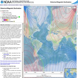
A compass will always point along the lines of magnetic force (which converge on what are called the magnetic poles). The angle between the direction of force and the direction of the geographic north pole is called the declination. If a compass at your location is pointing to the right of true north, declination is positive or east, and if it points to the left of true north, declination is negative or west. As one moves across the surface of the globe, lines of constant magnetic declination are called isogonic lines. As the earth's magnetic field varies over time, the positions of the north and south magnetic poles gradually change. This map displays historical isogonic lines and magnetic poles calculated for the years 1590-2020. Years 1590-1890: calculated from the gUFM model Years 1900-2020: calculated from the IGRF Years 1890-1900: a smooth transition was imposed between models.
Statistics (GDP, unemployment, income, population, labour, education, trade, finance, prices,health,debt...) ArcGIS Desktop. This topic provides a set of links to a collection of various ArcGIS tutorials used to perform a number of common tasks in ArcGIS.
Find the tutorial that you would like to work through by clicking the links in the tables below. To work through the ArcGIS Desktop tutorials, you need to install the tutorial data from the ArcGIS Desktop Tutorial Data setup, which is part of the ArcGIS Desktop installation download or media. If the tutorial data has been installed on your system, look for it in C:\arcgis\ArcTutor (the default installation location). In many cases, you will need write access to that location to perform the tutorial. The ArcGIS Server Installation does not include tutorial data. The GIS Encyclopedia. 3D for Everyone.
Design and publish beautiful maps. GIS Tools for Hadoop by Esri. Looking at data without location, most of the time seems like looking at just part of a story.
Including location and geography in analysis reveals patterns and associations that otherwise are missed. As Big Data emerges as a new frontier for analysis, including location in Big Data is becoming significantly important. Data that includes location, and that is enhanced with geographic information in a structured form, is often referred to as Spatial Data. Doing Analysis on Spatial data requires an understanding of geometry and operations that can be preformed on it. Enabling Hadoop to include spatial data and spatial analysis is the goal of this Esri Open Source effort. GIS Tools for Hadoop is an open source toolkit intended for Big Spatial Data Analytics.
The GIS Tools for Hadoop toolkit allows users, who want to leverage the Hadoop Framework, to do spatial analysis on spatial data; for example: Getting started Developers can get started at Spatial Framework for Hadoop. How it all works? Welcome to the QGIS project!
Esri Support. GIS Blogs - CHRISTINA FRIEDLE. GIS Tools - CHRISTINA FRIEDLE. Equity Atlas 2.0. National Geologic Map Database. HomeCatalogLexiconMapViewStandardsComments Find Us: Accessibility FOIA Privacy Policies and Notices U.S.
Department of the Interior | U.S. Geological Survey Supported by the National Cooperative Geologic Mapping Program URL: Page Contact Information: Personnel Page Last Modified: Mon Oct 24 23:22:57 2016. Department of Administrative Services Oregon Geospatial Data Clearinghouse. Metro - Metromap. RLIS Discovery: Home. OpenStreetMap US. Geographic Data.