
BUNCHA maps. Maps Compare. Geofabrik Tools. Bing Maps and Google Maps, side-by-side. Compare Maps. Nutzungsbedingungen Scale = 1 : 111m z:3 2000 km 1000 mi Base Layer.
Compare. Smit1678/compare-map. Ocarto. OverlapMaps - Instantly compare any two places on Earth! OpenStreetMap vs. iPhoto maps. Transparent map comparison openstreetmap google bing yahoo. Données cartographiques ©2013 - Conditions d'utilisation Base Layer Google Streets Google MapMaker Google Aerial Google Physical Overlays OpenStreetMap Mapnik OSM Mapnik german style OSM Cycle Map ÖPNV Karte Mapquest OSM Hillshading Hiking Map ADFC Bicyclenetwork Map data © OpenStreetMap and contributors CC-BY-SA , NASA SRTM Permalink. Geteach.com. Anotherearth - compare two maps. Webkarten vergleichen. Presumably, you're looking at this map because you've downloaded a Web mapping application template from the ArcGIS.com map viewer or the JavaScript API Samples.
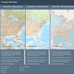
Follow the steps below to replace this map with your own. Deploy the Web application to your Web server Copy the application files to your Web server. Read the file named readme.html for instructions on deploying and configuring your application. Configure the Web application You can make simple changes to the Web application, like providing a different title, without having any programming experience. To get the map ID, go to www.arcgis.com and find the map you want to display. Webmap = 4ff792a3962547caad2d924413c40985 and substitute your map ID with the placeholder. Comparing US states with countries: Stateside substitutes.
Which countries match the GDP and population of America's states? IT HAS long been true that California on its own would rank as one of the biggest economies of the world. These days, it would rank eighth, falling between Italy and Brazil on a nominal exchange-rate basis. But how do other American states compare with other countries? Taking the nearest equivalent country from 2009 data reveals some surprises. Who would have thought that, despite years of auto-industry hardship, the economy of Michigan is still the same size as Taiwan's? Also see our other "country equivalents" interactive maps:Indian states and territories as countriesChinese provinces as countriesBrazilian states as countries. Compare ArcGIS.com Web Maps. MapFight - compare country size.
MAPfrappe - Move Outlines. Golden Gate Bridge/ Welcome to MAPfrappe, my interactive site for cartographic “mixtures.”

I hope you find it interesting! — Kelvin Thompson Move Outlines Version 3.01.Last updated 25 May 2013. This page allows you to see an outline of one part of the world overlayed on another part of the world. For example, you can sketch an outline of California in the “Reference Map” below, and then overlay the outline over Italy in the “Comparison Map.” You need basic knowledge of Google Maps interactions to get the most out of this web page. Here’s how you can use this page… 1) Click on the top, “Reference” map to draw an outline. ), or an open outline ( ), or several outlines ( ). 2) As you draw your outline in the top map, it appears at the center of the bottom map.
You can use this page to answer questions like these: How big is Manhattan compared to my home town? France versus South Africa Italy versus Japan Costa Rica versus Idaho Venice versus Key West Israel versus United Kingdom Australia versus The Sahara. Texas/Iraq. Welcome to MAPfrappe, my interactive site for cartographic “mixtures.”
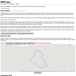
I hope you find it interesting! — Kelvin Thompson Move Outlines Version 3.01.Last updated 25 May 2013. Move Outlines. Welcome to MAPfrappe, my interactive site for cartographic “mixtures.”
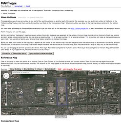
I hope you find it interesting! — Kelvin Thompson Move Outlines Version 3.01.Last updated 25 May 2013. GPS Tracking - TopTenREVIEWS. Cartography - How do I compare two maps to determine which is better. This reply describes an objective method to measure arbitrary discrepancies between two spatial datasets.
Such discrepancies can include shifts of position, changes of shape, and features present in one dataset but not in another. This reply does not provide any means to determine which is "better," because that depends on much more than just the data and it particularly depends on what the data will be used for. Background A good foundation for a large set of such measurements relies on the Euclidean distance transform of each dataset. This views each dataset as representing a collection of points in the plane. For any point x in the plane, the Euclidean distance transform of a point set A computes the greatest lower bound of the distances between x and A.
This figure shows the distance transforms of B (at the left) and R (at the right) in pseudo-relief. Comparing two datsets To compare B and R, overlay each with the distance transform of the other: