
TOPOMAPPER Compare Maps Nutzungsbedingungen Scale = 1 : 111m z:3 2000 km 1000 mi Base Layer Topographic Maps (Zoom In) Google Street Map Google Hybrid Map Google Terrain Map Bing Street Map Bing Hybrid Map Yahoo Street Map Yahoo Hybrid Map OpenStreetMap (Mapnik) OpenStreetMap (Tiles@Home) Map data hosted by Atlogis Topographic Maps (Zoom In) Google Street Map Google Hybrid Map Google Terrain Map Yahoo Street Map Yahoo Hybrid Map OpenStreetMap (Mapnik) OpenStreetMap (Tiles@Home) Click here for URL-Link of this View | Topographic Maps Coverage | Soviet Military Maps Documentation Earth - Your life on earth Explore BBC Earth's unique interactive, personalised just to you. Find out how, since the date of your birth, your life has progressed; including how many times your heart has beaten, and how far you have travelled through space. Investigate how the world around you has changed since you've been alive; from the amount the sea has risen, and the tectonic plates have moved, to the number of earthquakes and volcanoes that have erupted. Grasp the impact we've had on the planet in your lifetime; from how much fuel and food we've used to the species we've discovered and endangered. And see how the BBC was there with you, capturing some of the most amazing wonders of the natural world. Explore, enjoy, and share with your friends either the whole page, or your favourite insights. This is your story, the story of your life on earth. BBC Earth's Your life on earth is based on the following sources. Lead photo credit: John Kellerman / Alamy.
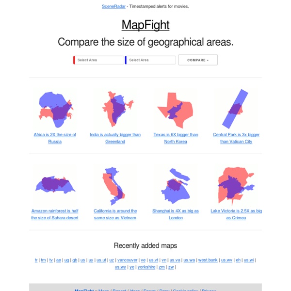
goggol 40 Maps That Will Help You Make Sense of the World If you’re a visual learner like myself, then you know maps, charts and infographics can really help bring data and information to life. Maps can make a point resonate with readers and this collection aims to do just that. Hopefully some of these maps will surprise you and you’ll learn something new. A few are important to know, some interpret and display data in a beautiful or creative way, and a few may even make you chuckle or shake your head. If you enjoy this collection of maps, the Sifter highly recommends the r/MapPorn sub reddit. 1. 2. 3. 4. Pangea was a supercontinent that existed during the late Paleozoic and early Mesozoic eras, forming about 300 million years ago. 5. 6. 7. 8. 9. 10. 11. 12. 13. 14. 15. 16. 17. 18. 19. 20. 21. 22. 23. 24. 25. 26. 27. 28. 29. 30. 31. 32. 33. 34. 35. 37. 38. 39. 40. *Bonus* World Map Tattoo with Countries Visited Coloured
Wakelet – Save, organize and share content transparent map comparison openstreetmap google bing yahoo Données cartographiques ©2013 - Conditions d'utilisation Base Layer Google Streets Google MapMaker Google Aerial Google Physical Overlays OpenStreetMap Mapnik OSM Mapnik german style OSM Cycle Map ÖPNV Karte Mapquest OSM Hillshading Hiking Map ADFC Bicyclenetwork Map data © OpenStreetMap and contributors CC-BY-SA , NASA SRTM Permalink A British geography quiz you can do in the car 8 August 2014Last updated at 20:43 ET How much do you actually know about Britain? Test your geography knowledge with these 20 quick questions. 1) Which is further west - Bristol or Edinburgh? 2) Coton in the Elms in Derbyshire is the furthest place from the coast - how far away is it? 1. 50 miles 2. 70 miles 3. 110 miles 4. 250 miles 3) How many deer live in the UK? 1. 2. 3. 4. 4) How much of the UK is woodland? 5) Which has the largest population? 1. 2. 3. 4. 6) How many counties border Wales? 1. 2. 3. 7) Which is the wettest city in the UK? 1. 2. 3. 4. 8) What percentage of people in the UK live in a town or city? 9) Which is the longest bridge? 1. 2. 3. 4. 10) Which is the longest motorway? 11) How many acres does Spaghetti Junction cover? 1. 2 acres 2. 10 acres 3. 30 acres 4. 60 acres 12) Which is the UK's longest river? 1. 2. 3. 4. 13) Put Belfast, Cardiff, London and Edinburgh in descending order of population size. 14) Southend-on-Sea in Essex has the UK's longest pier. 1. 297 metres 2. 987 metres 1.
Routenplaner - Kostenlose Routenplanung Mit dem Falk Routenplaner können Sie völlig kostenfrei alle Strecken von A nach B planen. Von kleinen Strecken bis hin zur langen Autoreise ins Ausland – dieser Routenplaner ist Ihr zuverlässiger Begleiter. Geben Sie als Startpunkt Ihrer Fahrt einfach die exakte Adresse, Ihre Stadt oder einen beliebten Ort an und wiederholen Sie diesen Schritt für Ihre Zielangabe. Willkommen auf dem neuen Falk.de! Probleme mit dem neuen Falk.de? Wenn Sie genügend Zeit für Ihre Reise mitbringen, gibt Ihnen der Routenplaner mit einem einzigen Klick die kürzeste und damit kostengünstigste Alternative an. Für die Verwendung dieses Routenplaners ist weder ein Login, noch eine Mitgliedschaft erforderlich. Zuverlässige Routenplanung Die im Falk Routenplaner verwendeten Daten beruhen auf aktuellen Straßenverläufen und Verkehrsdaten. Angabe von Halteplätzen Wenn Ihre Route eine längere Strecke umfasst, sollten Sie sich zwischendurch eine Pause gönnen. Alternative Fortbewegungsmittel Haben Sie eine eigene Website?
Wind Map An invisible, ancient source of energy surrounds us—energy that powered the first explorations of the world, and that may be a key to the future. This map shows you the delicate tracery of wind flowing over the US. The wind map is a personal art project, not associated with any company. We've done our best to make this as accurate as possible, but can't make any guarantees about the correctness of the data or our software. Please do not use the map or its data to fly a plane, sail a boat, or fight wildfires :-) If the map is missing or seems slow, we recommend the latest Chrome browser. Surface wind data comes from the National Digital Forecast Database. If you're looking for a weather map, or just want more detail on the weather today, see these more traditional maps of temperature and wind.