
Cloud Streets over the Hudson Bay. This page contains archived content and is no longer being updated.
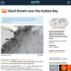
At the time of publication, it represented the best available science. On November 13, 2012, the Moderate Resolution Imaging Spectroradiometer (MODIS) on NASA’s Terra satellite captured this view of cloud streets amidst northwesterly winds over Hudson Bay. Traffic-free and Sky-high. These streets appear far whiter and whole lot more fluffy than their land-bound cousins.
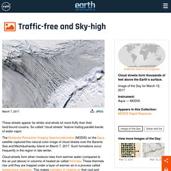
So-called “cloud streets” feature trailing parallel bands of water vapor. The Moderate Resolution Imaging Spectroradiometer (MODIS) on the Aqua satellite captured this natural-color image of cloud streets over the Barents Sea and Mezhdusharsky Island on March 7, 2017. Such formations occur frequently in the region in late winter. Cloud streets form when moisture rises from warmer water (compared to the air just above) in columns of heated air called thermals. A Honking, Fluttering Spectacle. The honking, fluttering spectacle of tens of thousands of snow geese in flight is a breathtaking sight—like watching “snowflakes drifting lazily across the azure sky,” in the words of naturalist and historian George Bird Grinnell.
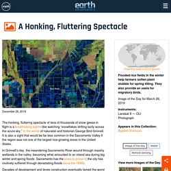
It is also a sight that would be far less common in the Sacramento Valley if the region was not one of the largest rice-growing areas in the United States. In Grinnell’s day, the meandering Sacramento River wound through marshy wetlands in the valley, becoming what amounted to an inland sea during big winter and spring floods. Sacramento has the scars to prove it; the city has routinely suffered through devastating floods since the 1840s. Right Here, Right Now. “It suddenly struck me that that tiny pea, pretty and blue, was the Earth.
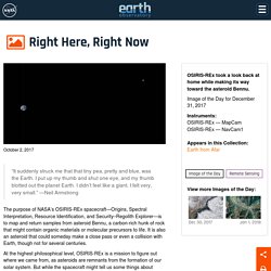
I put up my thumb and shut one eye, and my thumb blotted out the planet Earth. I didn’t feel like a giant. I felt very, very small.” PIA17748 JunoEarthMoonFlyby 640. Getting a Little Boost from Home. This page contains archived content and is no longer being updated.
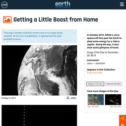
At the time of publication, it represented the best available science. In October 2013, NASA’s Juno spacecraft flew past the Earth to steal some energy for a ride to Jupiter. Along the way, it also stole some glimpses of home. To reach the outer planets in our solar system, mission planners usually chart a path that sends a spacecraft toward other small planets or the asteroid belt before falling back toward Earth by gravity. The technique allows the spacecraft to use natural gravity and momentum to increase its speed relative to the Sun and slingshot toward the outer solar system. Views of a Distant Earth. This page contains archived content and is no longer being updated.
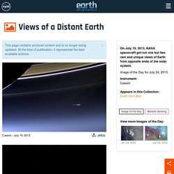
At the time of publication, it represented the best available science. On July 19, 2013, NASA spacecraft got not one but two rare and unique views of Earth from opposite ends of the solar system. Earth and Moon from Mercury. This page contains archived content and is no longer being updated.
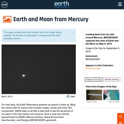
At the time of publication, it represented the best available science. On most days, the Earth Observatory presents our planet in close-up, filling the camera with its oceans and mountain ranges, clouds and rivers. Looking Back Across a Sea of Black. Every so often, we get a reminder of just how small our planet is in the context of the vast cosmos.
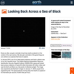
We also get a reminder of the great things we can achieve as a species that loves to explore. In January 2018, one of our latest space explorers sent back a distant view of our tiny, beautiful home. The Origins Spectral Interpretation Resource Identification Security–Regolith Explorer (OSIRIS-REx) spacecraft looked back across a distance of nearly 64 million kilometers (40 million miles) and saw the Earth and Moon as a few pixels of reflected sunlight. Icy Art in the Sannikov Strait. North of mainland Siberia, a set of islands protrude from the Arctic Ocean.
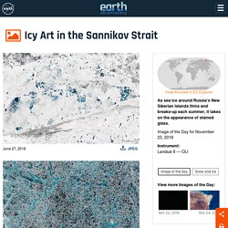
Spanning 30,000 square kilometers, the New Siberian Islands are bisected by the Sannikov Strait, which connects the Laptev Sea (west) with the East Siberian Sea (east). For most of the year, the strait is choked with ice. Phytoplankton Factory in the Argentine Sea. The Goldilocks zone typically refers to the habitable area around a star where conditions are right for the existence of liquid water and possibly life.
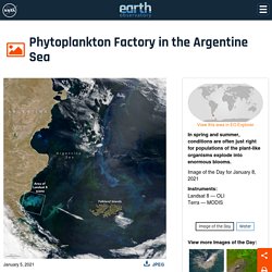
But on Earth, the South Atlantic Ocean has its own kind of Goldilocks zone. In spring and summer, conditions in the Argentine Sea off Patagonia often become just right for phytoplankton, and populations of the plant-like organisms explode into enormous blooms. In late 2020, satellite images started to show the colorful signature of phytoplankton blooms off the coast of Argentina and around the Falkland Islands (Islas Malvinas). Circles in Thin Ice, Lake Baikal, Russia. This page contains archived content and is no longer being updated. At the time of publication, it represented the best available science. Late in April 2009, astronauts aboard the International Space Station observed a strange circular area of thinned ice in the southern end of Lake Baikal in southern Siberia.
The Dark Side and the Bright Side. A NASA camera aboard the Deep Space Climate Observatory (DSCOVR) has captured a unique view of the Moon as it passed between the spacecraft and Earth. A series of test images shows the fully illuminated “dark side” of the Moon that is not visible from Earth. The images were acquired by NASA’s Earth Polychromatic Imaging Camera (EPIC), a four megapixel CCD camera and telescope on the DSCOVR satellite, which orbits about 1.6 million kilometers (1 million miles) from Earth. The Dark Side and the Bright Side. Night View of Fires in Siberia. This page contains archived content and is no longer being updated.
At the time of publication, it represented the best available science. For more than a decade, scientists have used data from instruments on NASA’s Terra and Aqua satellites to map the locations of wildfires burning around the globe. Now researchers have a new tool for observing fire. Polar Mesospheric Clouds Over Central Asia. This page contains archived content and is no longer being updated. At the time of publication, it represented the best available science. Polar mesospheric clouds (also known as noctilucent, or “night-shining” clouds) are transient, upper atmospheric phenomena that are usually observed in the summer months at high latitudes (greater than 50 degrees) of both the Northern and Southern Hemispheres. They appear bright and cloudlike while in deep twilight. They are illuminated by sunlight when the lower layers of the atmosphere are in the darkness of Earth’s shadow. This astronaut photograph of polar mesospheric clouds was acquired at an altitude of just over 200 miles (about 321 kilometers) in the pre-dawn hours (18:24:01 Greenwich Mean Time) on July 22, 2008, as the International Space Station was passing over western Mongolia in central Asia.
Clouds Light the Night. As spring turns to summer in the northern hemisphere each year, unusual streaks of clouds form high in the atmosphere around sunset in the world’s high latitudes (typically 50° to 65° North). On some days, the clouds are visible at middle latitudes. In June 2019, they have been stretching as far south as anyone can remember. The image above shows a satellite view of noctilucent or “night shining” clouds on June 12, 2019. Noctilucent Clouds. Elusive Sprite Captured from the International Space Station. Red Sprites Above the U.S. and Central America. A Stroke of Luck. Meteors Great and Small. Rare Refill of Lake Eyre, Australia’s Simpson Desert. From Russia with Questions. The Craziest Natural Phenomena You've Never Heard About - The Delite. (359) 4K Beautiful Mountains Aerial Views with Relaxation Music. (359) Majestic Mountains Aerial 4K with Calming Music. (359) Breathtaking Views of the Earth 4K.
(359) The Breathtaking Beauty of Nature. (359) 3 Hours of Amazing Nature Scenery & Relaxing Music for Stress Relief. (359) 3 Hour 4K Wonderful Aerial Views of the Earth with Relaxation Music. (359) 3 Hour 4K Amazing Aerial Views of the Earth with Relaxation Music. (359) A beautiful world from a bird's eye view 4K. (359) Mother Earth - Beautiful Nature Around The World 4K. (359) Earth From Space at Night - 1 hour of Calm Atmospheric Music with NASA ISS Footage (Arctic Audio) (359) The Blue Pearl III. (359) The Blue Pearl II. (359) The Blue Pearl I.
(359) Earth From Space at Night - 1 hour of Calm Atmospheric Music with NASA ISS Footage (Arctic Audio) Our incredible microscopic world, in pictures. Use the '20-5-3' Rule To Make Yourself Happier and Stronger. Description: This is a view from… Forest research makes UBC professor a Hollywood star. (936) SpaceX's Starship SN15 Flight Test in Boca Chica Starbase SCRUBBED.
(936) SpaceX's Starship SN15 Flight Test in Boca Chica Starbase SCRUBBED. Ethereal scenes as Fagradalsfjall continues erupting. Earth from space: Astronauts get the best views. (614) Mount St. Helens: America’s Deadliest Eruption. (614) Minute by Minute: The Eruption of Mount St. Helens. Minute by Minute: The Eruption of Mount St. Helens.
All Alone in the Night - Time-lapse footage of the Earth as seen from the ISS. (614) ORBIT - A Journey Around Earth in Real Time [ 4K Remastered ] (614) Efforts continue to free Ever Given ship from Suez Canal. (614) Simulation of EVER GIVEN Accident in Suez Canal 2021 in 3D by FleetMon. The Suez Canal Experience: Ship Transit Southbound. (614) Efforts continue to free Ever Given ship from Suez Canal. (614) Tugs, dredgers continue work to refloat ship blocking Suez Canal. (614) Simulation of EVER GIVEN Accident in Suez Canal 2021 in 3D by FleetMon. (614) Volcanic eruption in Iceland - Live - Friday 26th - Camera 2. (614) Iceland Volcano Closeups (March 28, 2021) Iceland Volcano Closeups (March 28, 2021)
(614) Live Feed: Iceland Volcano Eruption near Reykjavik. (614) Geldingadalur Volcanic Eruption - Iceland. Volcanic eruption in Iceland - Live - Friday 26th - Camera 2. (614) Volcanic eruption in Iceland! Live - Sunday 28th. (614) Timelapse - Volcanic eruption in Iceland - 9PM to 9AM Friday to saturday. (614) Side of Volcano Breaks Apart in Iceland. (614) 7 days, Two Minutes - Volcanic Eruption in Geldingadalir Iceland - Time-Lapse. (614) Side of Volcano Breaks Apart in Iceland. U of A researcher pitches mineral carbonation as solution to climate change to U.S. policy makers. These are the last unspoiled places on Earth. The beautiful and terrifying power of Mother Nature in 29 incredible photos. The most magical places on Earth. These are the world's most beautiful waterfalls. Stunning images of the world's most incredible canyons.
The world's most jaw-dropping sculptures and statues. Pompeii’s secrets that are only just being uncovered. Secrets of the world’s most beautiful mountains. The new 50 wonders of the world revealed. Alberta to expand world's largest connected stretch of boreal forest preserve. The Royal Family on Instagram: “□‘We've forgotten sometimes I think that we are part of nature. So what we do to the world around us, we are doing totally to…” This is What Winter Looks Like in Alberta and Saskatchewan. UN survey uses Angry Birds to reveal Canadian, global opinions on climate policies.
First Look At Sir David Attenborough’s New Nature Series ‘A Perfect Planet’ ‘A Perfect Planet’: David Attenborough talks narrating nature series amid COVID-19 lockdown. The Best Photos Of Last Year Captured By Drones Have Just Been Announced, And They're Truly Spectacular. The Best Photos Of Last Year Captured By Drones Have Just Been Announced, And They're Truly Spectacular. Untitled. Untitled. Untitled. Untitled. Untitled. Untitled. Untitled.