
Live Twitter Geographic Updates. 3-D Maps of Geolocated Tweets. Buffer: Pizza Near Me. Buffer: VIEWSHED. Buffer: Polygon Selectable Distance. Esri, DeLorme, FAO, IFL, NGA, NOAA, USGS, EPA | Pick a tool and draw on the map.
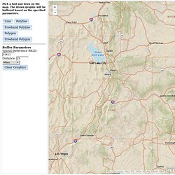
The drawn graphic will be buffered based on the specified parameters. ●Line ●Polyline ●Freehand Polyline ●Polygon ●Freehand Polygon. Buffer: Population Selectable Area. (c) ESRI and its data partners | Esri, DeLorme, FAO, IFL, NGA, NOAA, USGS, EPA |
Buffer: Driving Distance (123) ESRI Disaster Response: Home. ESRI Severe Weather Live Updates (Crowdsourced) ESRI Disaster Response: Flooding. Renewable Energy Map Data. TypeBrewer. CHANGE OVER TIME SAT. World History Atlas & Timelines. Wikimapia: Let's describe the whole world! Google Earth Outreach. De plus en plus d'organisations font appel à des appareils mobiles pour collecter des données sur le terrain.
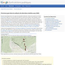
Open Data Kit (ODK) est une suite d'outils permettant de collecter des données à l'aide d'appareils mobiles Android et de soumettre ces mêmes données sur un serveur en ligne, même sans connexion Internet ou couverture d'opérateur mobile au moment de la collecte des données. Simplifiez le processus de collecte de données avec ODK Collect en remplaçant les anciens formulaires papier par des formulaires électroniques qui permettent d'importer du texte, des données numériques, des coordonnées GPS, des photos, des vidéos, des codes-barres et des sons sur un serveur en ligne.
Vous pouvez héberger vos données en ligne avec la puissante plate-forme d'hébergement de Google, AppEngine, gérer vos données avec ODK Aggregate et visualiser vos données sous la forme d'une carte à l'aide de Google Fusion Tables et de Google Earth. Commençons sans plus attendre 1. 2. Discussions et commentaires. Google Earth Tutorials. Hierarchical Patterns of Urbanization. Christaller's CPT was evolved from the concept of centralization as an ordering principle.
Chirstaller proposed that if the centralization of mass around a nucleus is an elementary form of order, then the same centralistic principle can be equated in urban settlements. The Christaller model proposed a hierarchical arrangement of settlements and conceptualized the model with hexagonal arrangements. The hexagon best equated a circle for maximum coverage and some of the problems of overlap within circular arrangements were removed from hexagonal arrangements. The population size and importance of a settlement were not necessarily synonymous, but the centrality of the place was conceptualized in terms of its importance in the region around it. The theory consisted of the basic concepts of centrality, threshold, and range.
Extensions and modifications to Christaller's CPT have been proposed. Social Explorer. MapStory : MapStory. Patagonia's Supply Chain Map. Tableau Mapping Co. 38 Maps You Never Knew You Needed. Social Map South Africa. Trialogue estimates that companies in South Africa channelled R5.1 billion into projects targeting beneficiaries in poor communities in 2009.
The South African government of course invests almost one hundred times this amount in social development, education, health and housing. The Social Map is designed to enhance the impact of such social investment by showing the extent of investment in relation to socio economic needs by geographic region and development sector. The map depicts this information in an easily accessible form on a Google Earth platform.
Investment can be seen at various geographic levels: project, local municipality, district municipality, province or national. It can also be viewed by sector including health, education, community support and 16 others. The Social Map aims to facilitate more effective social investment by providing powerful information for strategic decision-making. There are different levels of access to the data on the map. India Geospatial Forum 2013. Tagged Village Map. Indian State Equivalents. Centre for Science and Environment. S. Daniel Abraham Center for Middle East Peace.
The S.
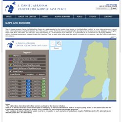
Daniel Abraham Center for Middle East Peace is a leading expert on the border issue related to the Middle East conflict, at times helping decision makers make informed decisions about the borders. .:Palestinian Hydrology Group. Americans for Peace Now. West Bank Barrier Over the past decade Israel has constructed a barrier - part fence and accompanying security roads and set-back areas, part cement wall - to separate Israel from the West Bank.
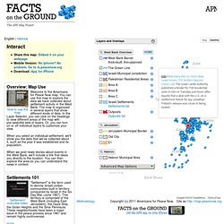
Much of this barrier is located inside the West Bank, de facto annexing West Bank territory to Israel. Think-Israel. By Aubrey Wulfsohn Except perhaps in a rain forest, deciding who controls the water supply has been a major direct and indirect reason for hostilities between neighbors since ancient times.
In the Holy Land, there is a long history of water disputes way back to the time when our fathers Abraham and Isaac were digging wells for water for their flocks, wells that were subsequently seized by the Philistines[1] based around the present-day Gaza strip under their king Abimelech. Eventually Abraham and Abimelech entered into a treaty in which Abraham promised that his descendants would not attack the Philistines. This did not stop the Philistines from stopping up or confiscating Isaac's wells nor from attacking Israel during the period of the prophets. Particularly in the Middle East, water can never be ignored.
As almost everywhere else in the world, Israel's ultimate source of water is natural rain fall. The Jordan is Israel's largest river. NOAA Nightsat. Meteoritessize. Global Forest Change.