
Big Dams: Boon or Bane? The Mekong River arises in the Tibetan Plateau of southern China and descends through a series of spectacular gorges into Laos, Cambodia, and Vietnam.
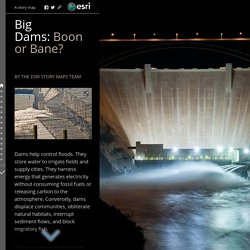
The lower river widens into vast marshlands and deltas, upon which hundreds of thousands of people depend for their livelihood. Multiple dam projects, some completed, some under construction, and others planned, are dramatically changing the face of the river. The DON SAHONG DAM is under construction in Laos, just north of the Cambodian border, one of nine Mekong dams planned by the Laotian government. Immediately downriver is the habitat of the Iriwaddy Dolphin; fewer than 100 remain on the river.
The dam blocks the one channel of the river at Khone Phapheng Falls that is wide and deep enough for migrating fish. The XAYABURI DAM in northern Laos is in the latter stages of completion. These and other dams on the upper Mekong dramatically reduce the flow of sediments to the Tonle Sap wetlands in Cambodia and the Mekong Delta in Vietnam. GaugeMap. The Water Cycle for Kids and Students. The water cycle describes how Earth's water is not only always changing forms, between liquid (rain), solid (ice), and gas (vapor), but also moving on, above, and in the Earth.
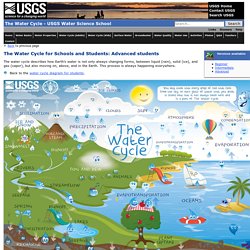
This process is always happening everywhere. Back to the water cycle diagram for students. Animals In the grand scheme of the water cycle, animals may not play a very big role, but all animals, including you, participate in moving water around as part of the water cycle. The water cycle is critical to all animals and life on Earth. There is one creature on Earth that does have a very large impact on the water cycle—human beings. Atmosphere The atmosphere truly is the superhighway in the sky that moves water everywhere over the Earth. The next time you go outside you will be standing in the Earth's atmosphere.
The air outside may look invisible, but it is full of molecules, including water molecules, as water vapor. How much does a cloud weigh? Clouds are made of water, and water has weight, so how can they float? Lakes. UK winter storms. 20 February 2014Last updated at 08:14 ET January's wet weather in numbers Slow threat of groundwater flooding The reasons behind one of the stormiest months Turbulent seas and wave watchers being caught out Aerial imagery and photos along the Thames Eyewitness accounts from storm-hit areas The Army moves in for a "rapid inspection" of flood defences The impact of the floods on wildlife How bad are 2014's floods compared with 2007?

River Landforms - The British Geographer. Changing Channel characteristsics. Width and depth are simple variables and generally increase downstream as more water is added from tributaries.

Width can be derived either from the water surface width (occupied channel width) or from measuring from bank to bank, giving the bank full width. We can calculate the stream order from source to mouth too, and this gives us an indication of the size and shape of river channels. The stream order is calculated as follows; Stream order 1 streams have NO tributaries feeding into them, they are the original streams that start at springs up in the source.
Stream order 2 streams occur where two stream order 1 rivers come together at a confluence. Formation of a delta. Rejuvenation. Ees.as.uky.edu/sites/default/files/elearning/module12swf.swf. Complete storm hydrograph in small stream channel. Braided stream sediment flume experiment.