
Free Online softwares. MapRef.org - Map Projections DE. Map Projections. Flattening the Earth It’s impossible to flatten the Earth without distorting it in some fashion.
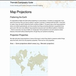
Consider an orange peel: if you want to try and lay it flat, you have to stretch it, squash it, and tear it. Likewise with the Earth—if we want to make a map, we need to distort the Earth’s surface to flatten it. The good news is that map projections allow us to distort systematically; we know exactly how things are being stretched or squashed at any given point. We have many different map projections because each has different patterns of distortion—there is more than one way to flatten an orange peel. Projection Properties We often talk about map projections in terms of the ways in which they distort or preserve certain things about the Earth, which we call projection properties. Area — Some projections distort areas (e.g., Mercator projection) Notice how Greenland is about as big as South America on a Mercator projection. Projections like this are called conformal projections. GPS/UTM-Koordinatensystem,WGS84- Kartendatum.
Geographische Koordinatensysteme ermöglichen die genaue Ortsbestimmung auf der Erdoberfläche in Form von eindeutigen Zahlenwerten.
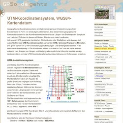
Das bekannteste geographische Koordinatensystem ist das Koordinatennetz bestehend aus Längen- und Breitengraden (Longitude und Latitude). Zu finden ist dieses auf Globen, Atlanten und vielen Landkarten. Auf neueren GPS-geeigneten Landkarten, Straßenkarten oder Stadtplänen wird dagegen fast ausschließlich das UTM-Koordinatensystem verwendet (UTM= Universal Transverse Mercator). Der große Vorteil von UTM-Koordinaten gegenüber Längen- und Breitengraden besteht in der einfacheren Handhabung: UTM-Koordinaten lassen sich direkt in "km" von der Karte ablesen, während zum Ablesen von Längen- und Breitengraden zusätzliche Hilfsmittel benötigt werden.
Außerdem lässt sich das UTM-Koordinatengitter gut zur Abschätzung von Entfernungen einsetzen. The World Coordinate Converter. TWCC The World Coordinate Converter - Le convertisseur de coordonnées universel > The World Coordinate Converter - Systèmes de référence. MapRef.org - ToC. UTM, WGS84. Convert coordinates between latitude/longitude and easting/northing - Franson CoordTrans. Grids and Datums 2011 - Present. Skip to content Home PE&RS Journals.
U) The Universal Grid System (UNCLASSIFIED) Geodetic Datum Overview. These materials were developed by Peter H.
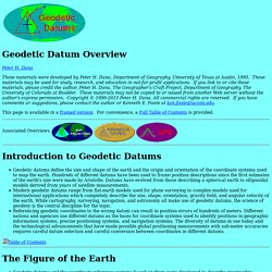
Dana, Department of Geography, University of Texas at Austin, 1995. These materials may be used for study, research, and education in not-for-profit applications. If you link to or cite these materials, please credit the author, Peter H. Dana, The Geographer's Craft Project, Department of Geography, The University of Colorado at Boulder.
These materials may not be copied to or issued from another Web server without the author's express permission. This page is available in a framed version. Associated Overviews Geodetic datums define the size and shape of the earth and the origin and orientation of the coordinate systems used to map the earth. Table of Contents Geodetic datums and the coordinate reference systems based on them were developed to describe geographic positions for surveying, mapping, and navigation. Geometric Earth Models Reference Ellipsoids Earth Surfaces The earth has a highly irregular and constantly changing surface. Datum Types.