background preloader

Webmapping

Facebook Twitter

[Startup] MapsData. 7 Mapping Tools for Hyperlocal Publishers. GPS Visualizer. Create your own maps on the Internet in a personalized environment. AmMap: Interactive flash maps. 欢迎您! - WorldMap. Blog, CartoDB makes D3 maps a breeze. Anybody who loves maps and data can’t help but notice all the beautiful visualizations people are making with D3 right now. 
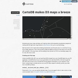
Huge thanks to Mike Bostock for such a cool technology. We have done a lot of client-side rendering expirements over the past year or so and have to say, D3 is totally awesome. This is why we felt it might be helpful to show you how easy it is to use D3 with CartoDB.

In the near future, we’ll be adding a few tutorials for D3 to our developer pages, but for now, let’s have a look. Creating your first map Using CartoDB’s SQL API, you can load GeoJSON straight from your CartoDB table into your D3 application. Paired with d3.geo, you can quickly develop maps. TopoJSON support We are actively working on supporting TopoJSON in CartoDB and when deployed, this will open the door to even faster D3 maps. Client-side simplification Many of you have probably seen some of the cool client-side simplification work that is being done.

Web Maps. Cartography on the Web. Map Servers[Maps] [Software] [Photos] Google Maps This is my default mapping program, with an amazingly fast user interface which lets you drag the map with your mouse. Here is where I work. U.S. Geological Survey The USGS covers many topics in geology, mapping, and water resources. The National Map is an interactive display of the entire country as a topographic map, with variable overlays.

Maps are accessible through the Digital Elevation Map index The University of New Hampshire has 1903 USGS maps of New England on line. The University of Iowa serves 1:24000 and 1:100000 maps of Iowa. TopoZone has adjustable-scale USGS topographic maps for the entire United States online. Map Machine An interactive online atlas based on the National Geographic Society Atlas of the World. Earth Maps(tm) DeLorme Mapping provides street-level maps and trip routing for any location in the US, with a simple interface and faster response time than their competitors. Harvard Geospatial Library MapQuest MapBlast!

U.S. My Map. MapAList - Create and Manage Maps of Address Lists. Create Maps | BatchGeo. Indiemapper.com.