
J&B Softlabs. Key Features - You don't need to prepare map files any more. - You don't need to get coordinates of certain point or area. - You can make 6 leveled maps that each level have double magnifications comparing with lower level. - Converting points, routes from Google Earth(kml file) to PathAway.
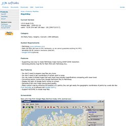
. - Display the path of Google Earth routes on screen - Generate 8-bit color maps having good quality. - Make custom map by entering the position of 2 points. (You can get easily the geographic coordinates of points by a web site like Free Geocoder or a software like Google Earth. Screenshots New york map from Google Maps (Normal mode/ 25% zoomed out) New york map from Google Maps (Satellite mode/ 25% zoomed out) New york map from Google Maps (Terrain mode/ 25% zoomed out) New york map from Yahoo! New york map from Yahoo! New york map from OpenStreetMaps.org (Normal mode/ 25% zoomed out) Sanghai map from Google Maps China (Normal mode/ 100%) screen capture of maps in PDA. IMG Datein ins Mapsource einbinden (Videoanleitung) United States.
Before downloading a custom map to your device, here are a few things to keep in mind: Make sure your device is compatible.Your device needs to have the latest available software.Only create a custom map from a map that is in the public domain, that you hold the copyright in, or that you have permission to use from the copyright holder. Printer-friendly Instructions Step 1: Save the map as a JPEG. If your map is printed, scan the map at an appropriate resolution¹, and save the image as a JPEG.
If your map is electronic, such as a PDF, it may require conversion using GIMP or another suitable program to save it as a JPEG. Step 2: Create an Image Overlay Using Google™ Earth, locate the approximate area² where your custom map is located. Step 3: Link the JPEG In the New Image Overlay window: Provide a name. Step 4: Georeference the JPEG Adjust (georeference) the JPEG so it matches the satellite imagery beneath the image overlay. Click OK to save your custom map. Disabling Custom Maps. Your Tool For Creating Maps. Locking included with one FID!
170 USD - Buy it with Share*it After purchase allow me maximum 24h for delivering registration which will activate locking option. cGPSmapperKey program will be sent together with the registration. If you prefer, you can also buy program using BitCoins ( 14 BTC ). Send me by mail your registration name - I'll send you back BTC address to do the transaction This version comes with right to create commercial maps. Commercial version cGPSmapper locking option Activation of locking option in cGPSmapper 1 FID value included cGPSmapperKey - key generator for registered FIDs - generates unlock keys for given GPS ID - allows to assign map to the specific device.
Anleitungen sowie Tipps & Tricks : IMG Karten in Mapsource oder auf GPS Gerät installieren. Karten im IMG Format auf GPS Gerät übertragen oder in Mapsource installieren 1. ezMS - Free Garmin Mapsource Mapset Manager Der Free Garmin Mapsource Mapset Managere, Karten im IMG Format in Mapsource zu integrieren, danach in Mapsource Routen zu planen und am Ende Karte + Routen ins GPS Gerät zu übertragen.
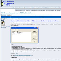
Anleitung: 1. Download und installiere ezMS 2. Download --> ezMS Infos --> 2. Das MapSetToolKit ermöglicht es, Karten im IMG Format in Mapsource zu integrieren, danach in Mapsource Routen zu planen und am Ende Karte + Routen ins GPS Gerät zu übertragen. 3. Der GPS Map Manager ermöglicht es, Karten im IMG und TDB Format in Mapsource zu integrieren, danach in Mapsource Routen zu planen und am Ende Karte + Routen ins GPS Gerät zu übertragen. Hier ist zu sehen, welche Karten schon in Mapsource integriert sind. Mit dem "Create" Button öffnet man dieses Fenster um neue Karten zu integrieren. Download --> GPS Map Manager 4. Download --> GPS Send Map 5. Download --> IMG2GPS 5. Download --> IMG2MS.