
Getting Started With Google Earth - National Geographic Society. Teaching With Google Earth - National Geographic Society. StreamStats 4.0. NWS Flood Information. Land Remote Sensing Image Collections. The Land Remote Sensing Image Gallery allows users to see how the surface of the Earth is changing rapidly, at local, regional, national, even global scales, with significant repercussions for people, the economy, and the environment.
Hurricane Irma Slams BarbudaHurricane Irma was a Category 5 superstorm when it lashed the Caribbean island of Barbuda on September 6, 2017. Southern California Wildfires UpdateSanta Ana winds rapidly spread wildfires through shrubland, tall grasses, and brush in southern California in December 2017. Southern California Wildfires, December 2017Santa Ana winds rapidly spread wildfires through chaparral shrubland, tall grasses, and brush in southern California in December 2017. New Rift on Greenland's Petermann GlacierA new rift has been forming on Petermann Glacier, Greenland, throughout 2017. Isle de Jean Charles, LouisianaIs Louisiana falling into the sea, or is the sea inundating Louisiana? Africa on the world map: What's the real size?
Home to six time zones, its endless plains spread from ocean to ocean, dominating great swathes of the northern half of the globe.
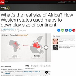
But, in reality, three Canadas would comfortably fit inside Africa. Our world map is wildly misleading. It's all down to the European cartographer Geert de Kremer, better known as Mercator, and his 16th century map projection. While a convenient way to chart the world, the map distorts the true size of countries. "Somehow this map projection came to be used on most world maps, especially those produced for classrooms since the beginning of the 1900s," says Menno-Jan Kraak, president of the International Cartographic Association and professor of cartography at the University of Twente, Netherlands.
"Most of us have grown up with this world image. " Made for captains Mercator initially made globes. Mercator's solution was to stretch out the northern and southern extremities of the globe to fill those gaps, producing an elegant and usable map. A political tool? ESRI-Education. Interpreting "Earth at Night" Images. Students Map Real-World Issues with (Free) Geospatial Tools. Imagine being an emergency responder in a small town that hasn't mapped its fire hydrants, labeled rural roads with street signs, or identified evacuation points in the event of natural disaster.
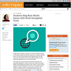
Now imagine being part of a high school team that addresses those issues by thinking critically and using sophisticated geospatial tools to communicate findings. Until recently, only a small number of schools have had access to the high-powered geographical information system (GIS) software that enables detailed, layered mapping and analysis of data.
Thanks to a recent $1 billion pledge from software developer Esri, free access to cloud-based mapping software is coming to 100,000 K-12 schools across the country. The donation of ArcGIS Online, the same software that governments and businesses use, has been pledged through ConnectED, a White House initiative to improve education in the STEM fields. Schools around the world. Google Earth for Educators: 50 Exciting Ideas for the Classroom. March 14th, 2010 Google Earth has opened up potential for students in classrooms around the globe with its bird’s-eye view of the world.
Whether you are a veteran teacher looking for new ways to teach old topics or you are a still an education student getting ready to make your debut in the classroom, these exciting ways to use Google Earth are sure to infuse your lessons with plenty of punch. Find ideas for any age student and a handful of virtual tours that will not only help you instruct your students, but might even teach you something along the way.
Elementary Younger students can have fun with these Google Earth lessons and ideas. Meteors. Middle School These lessons cover a wide range of subjects and are just right for middle school students. San Francisco: visualizing a safer city. High School and Beyond These lessons are great for high school and college students and include literature, geography, history, and more. Mount McKinley Elevation Survey Results Coming Soon (7/23/2015 9:30:00 AM) A team of four climbers has recently returned from the highest point in North America with new survey data to determine a more precise summit height of Mount McKinley.
It is anticipated the new elevation finding will be announced in late August. The ability to establish a much more accurate height has grown with advances in surveying technologies since 1953 when the last official survey of Mount McKinley was recorded. The new elevation will eventually replace the formerly accepted elevation of 20,320 feet. ”Determining an updated elevation for the summit of Mount McKinley presents extraordinary challenges,” said Suzette Kimball, acting director of the USGS. “The USGS and its partners are using the best available modern GPS survey equipment and techniques to ensure the new elevation will be determined with a high level of accuracy and confidence.”
In 2013, an elevation was calculated for Mount McKinley using a technology known as Interferometric Synthetic Aperture Radar (ifsar). 38 maps that explain the global economy. New HD View of Earth at Night. Canadian Wildland Fire Information System.