
Haywood, J.: The New Atlas of World History: Global Events at a Glance. La guerre globale enseigne la cartogaphie globale. Disons le d’emblée, l’objet de l’étude du jour a un statut un peu particulier car il servira désormais de logo à cette « histoire globale par les sources » entamée depuis le mois de septembre dernier.
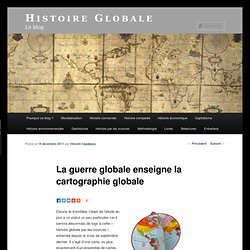
Il s’agit d’une carte, ou plus exactement d’un ensemble de cartes assemblées en un globe, un globe plat et dépliable : un fold-O-globe. Le brevet en a été déposé en 1942 par Gerald A. Eddy, cartographe connu pour ses représentations panoramiques (par exemple de Los Angeles). Selon son concepteur, l’objet est révolutionnaire : « ‘Rond comme la Terre elle-même’, ce fold-O-globe représente la première invention importante en 474 ans : une projection cartographique en continu conçue de manière à montrer en un seul coup d’œil les pays et les villes les plus importants dans le Monde et les véritables relations entre les continents. » Figure 1. L’entrée en guerre des États-Unis après deux décennies de relatif isolationnisme a provoqué une réelle rupture dans la vision états-unienne du Monde. Random notes: geographer-at-large. Anthropomorphic and Zoomorphic Satirical Maps:#1.
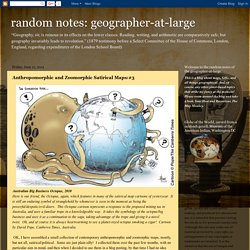
Detail of India from “The Illustration of The Great European War No.16 -- A humorous Atlas of the World,” by Tanaka, published in Japan, 1914. A rare satirical / political map f rom the Asian Perspective. There is a whole genre in map-making that entails using anthropomorphic or zoomorphic figures in maps. This is a tradition that began in the mediaeval times and continues until the present day. There are several sub-genres of these anthropomorphic maps, one of which is the satirical or political cartoon type map which uses animals or people to create the outline borders of nations. These are very cleverly done, and are often brilliant commentaries on events or circumstances of the day, usually espousing a partisan point of view of the facts. I have (way too) many examples of these kinds of maps, some of which I include here, but this is by no means an exhaustive collection.
Anthropomorphic and Zoomorphic Satirical Maps:#2. Detail of China from “The Illustration of The Great European War No.16 -- A humorous Atlas of the World,” by Tanaka, published in Japan, 1914. A rare satirical / political map f rom the Asian Perspective. The China-as-pig figure is seen examining the Manchurian lands of the former Qing Dynasty (ousted in the revolution to be replaced by the early form of the Republic of China) through a magnifying glass. The Gerrymander, 1812 “The painter Gilbert Stuart was inspired by the awkward shape of an electoral district on a map he saw in a newspaper editor’s office. Anthropomorphic and Zoomorphic Satirical Maps:#3. Australian Big Business Octopus, 2010 Here is our friend, the Octopus, again, which features in many of the satirical map cartoons of yesteryear.
It is still an enduring symbol of stranglehold by whomever is seen in the moment as being the powerful/despotic/evil-doers. This Octopus cartoon represents a response to the proposed mining tax in Australia, and uses a familiar trope in a knowledgeable way. Rediscovering African Geographies. The Catalan Atlas , 1375, by Abraham Cresques – detail showing Northern Africa, with a depiction of The King of Mali and Lord of Guinea, Mansa Musa, 1312-1337, seated on his throne in a stately fashion with crown, orb, and scepter, with the inscription: The richest and noblest King in the world.
Unconventional (yet informative!) Maps of the Big Apple. Here are some cool maps on New York City (and yes, I am aware that for the most part, this means Manhattan below 96th Street!
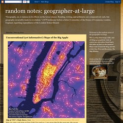
But what can one do?). Ahhh....New York City, aka The Big Apple. Or “the big stinky apple,” as one of my nephews calls it (btw, he’s NOT a New Yorker, obvio!). With a few exceptions, they are all relatively recent maps. I couldn’t resist adding in a couple of vintage examples, such as the Beerdom Map of the Lower East Side (1885). Maps Showing Basic Facts about NYC 3-D Map of Lower Manhattan, overlain on an historic map Google Earth has added part of the David Rumsey Historical Map Collection to their software. Rich Guy Map “Where are all the rich, single guys in Manhattan? NYC Photo-taking maps Taking city maps and overlaying them with the frequency of photo taken and posted to Flickr by local residents as compared to tourists.
Blue pictures are by locals. NYC Play Around Map. TimeMaps - World History TimeMap. The Map Scroll. European History Interactive Map. The Flow of History. The map as history : a multimedia atlas of world history with animated historical maps. World History : HyperHistory.