
Trippermap - get a flash world map of your flickr photos. TourSphere Home. Interactive Javascript Maps. Create interactive maps and visualizations with your data. Aeon Timeline: The timeline tool for creative thinking. It's about the Apps, not the Maps! Snazzy Maps - Free Styles for Google Maps. jQuery Mapael - Ease the build of pretty data visualizations on dynamic vector maps. Map with some plotted cities, areas and zoom enabled.
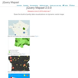
Try it » Map with a legend for plotted cities. Try it » Map with multiple plotted cities legends that handle different criteria. Try it » Dataviz example : evolution of the population by country through the years. Map with links between the plotted cities. Download the latest version (2.0.0) #Overview jQuery Mapael is a jQuery plugin based on raphael.js that allows you to display dynamic vector maps. For example, with Mapael, you can display a map of the world with clickable countries. Mapael supports all modern browsers and Internet Explorer 9+. Click here to download the lastest stable release of Mapael from GitHub. Key features based on jQuery and raphael.js. #Basic code example Here is the simplest example that shows how to display an empty map of the world : Javascript Result #Code examples Basic Advanced #API reference (version 2.0.0) All options are provided as an object argument of the function $.fn.mapael(Object options).
#Extend Mapael. Mashupforge: Create beautiful maps. The next most obvious thing. Kartograph.org. Leaflet - a JavaScript library for mobile-friendly maps. A Free Map Quiz Game. Конструктор. ArcGIS Resources. МИР КАРТ: Интерактивные карты стран и городов. Карта Москвы, России, мира, Афганистана, Ирака, Кувейта, Чечни, Курортов Средиземноморья, Новосибирска, Екатеринбурга, Ростова-на-Дону, Челябинска, Иркутска, Мурманска, Хабаровска, Нижнего Новгорода, Пущино.
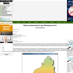
Обзор интерактивных карт Всемирной сети. Светлана Шляхтина Сферы применения интерактивных карт Интерактивные flash-карты Обычные интерактивные ГИС-карты Поиск точки на карте Поиск оптимального маршрута Карты в качестве рекламного инструмента Карты как инструмент для принятия бизнес-решений Интерактивные ГИС-карты с визуализацией Земля с высоты птичьего полета Google Earth NASA WorldWind Москва с высоты птичьего полета 3D Moscow Model Map — 3D-модель Москвы Еще совсем недавно желающим сориентироваться на местности приходилось раскладывать на столе или на полу огромную карту и тратить немало времени на поиск интересующего их объекта.
Есколько лет назад на смену бумажным картам и атласам пришли электронные, или интерактивные, карты, позволяющие находить любые объекты в считаные секунды: достаточно ввести название объекта, щелкнуть на соответствующей кнопке, и нужный фрагмент карты окажется перед вами. StoryMap JS - Telling stories with maps. OpenStreetMap. Where is this?
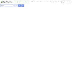
Reverse Directions Welcome to OpenStreetMap! OpenStreetMap is a map of the world, created by people like you and free to use under an open license. Hosting is supported by UCL, Bytemark Hosting, and other partners. Learn More Start Mapping <div id="noscript"><p>You are either using a browser that does not support JavaScript, or you have disabled JavaScript. 300 km 100 mi © OpenStreetMap contributors ♥ Make a Donation Directions from hereDirections to hereAdd a note hereShow addressQuery featuresCentre map here. Welcome - GeoServer. Яндекс.Карты. Welcome to MapServer — MapServer 6.4.1 documentation. ArcGIS. Maps for the Web, made easy - CartoDB — CartoDB. Google Developers. Bing Maps. Design and publish beautiful maps. Map creator online to make a map with multiple locations and regions.
Добро пожаловать на страницу проекта QGIS! Micello. Your travel journal. Create. Share. Explore. Stay.com Social City Guides. Mapwing - Build and Share Virtual Tours for Free. Woices.com - location based audioguides. Geotagging of Youtube videos. Trip Planner. CommunityWalk - make your own map, build interactive maps, create a map with photos, videos, more. Free Mobile Travel Blog - publish using Email, SMS, MMS or iPhone. Mapme - Map Your Community. Geotag - Welcome to Geotag. Scribble Maps : Draw On Maps and Make Them Easily.