
Street World View. Radius Around a Point on a Map. You can use this tool to find the radius around a point on the map. First type in the radius required in kilometers or miles and then click on the map at the center of where you wish the circle to appear. You can then create as many radii as you wish. Options Radius Distance km OR miles OR feet OR meters Instructions Type in a radius required in the text box above. Use the "URL to last radius" text box to find a URL that will show the most recent radius on this page when opened in a web browser. Google Earth KML Output You can now export all the drawn radii on the map to Google Earth for improved display and printing.
The procedure to Export to KML is as follows: Draw one or more radii on the map as you see fit Once ready, click the [Generate KML] button. Currently, the KML will include: The same radius size and shape Transparency of 50% It will not include: These features may be added later depending on feedback. CSV Upload The CSV option allows you to upload bulk points to the map. Future Ideas. Road Trip Genius Calculates the Shortest Route Through 47 National Parks. 12.4K 5ShareNew The National Park Service (NPS) celebrates its 100th birthday on August 25.
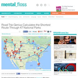
While hitting every NPS property in the system between now and then would be quite the challenge, this route spotted by The Washington Post is a great place to start. The “Optimal U.S. National Parks Centennial Road Trip” map is the creation of road trip mastermind Randy Olson. The trip includes stops at all 47 national parks in mainland America (for the sake of practicality, the 12 national parks in Alaska, Hawaii, and other U.S. territories were left out). Olson came up with the ideal route by plugging his destinations into the Gurobi TSP solver. To complete this latest trip, Olson suggests drivers set aside at least two months to fully take in the 14,500 miles worth of sites. [h/t The Washington Post] Know of something you think we should cover? August 2, 2016 - 9:00pm Michele Debczak is a staff writer for mentalfloss.com.
. ©2016 Mental Floss, Inc. A global map of wind, weather, and ocean conditions. GPS Based Aurora Borealis Forecast. Get the Probability of a Visible Aurora anywhere on Earth. This note should go away shortly.

If it does not, most likely the browser is not sharing its location with us. Look for some kind of pop up note on your browser and choose "always share location with this site. " If you are looking on a cell phone. Northern Lights Forecast. Hourly Aurora Forecast Using real-time solar wind data from Nasa’s ACE spacecraft, matched with some computer modelling, we are able to display with reasonable accuracy, how the aurora will behave up to one hour in advance.Image should be used as a guide only.
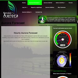
Aurora may be seen slightly higher or lower than the image shows on any given night. Right now, the aurora is predicted to be: Kp 1.00 In 0 hour and 17 minutes, the aurora is predicted to be kp 0.67 In 0 hour and 32 minutes, the aurora is predicted to be kp 0.67 In 0 hour and 48 minutes, the aurora is predicted to be kp 0.67 What do Kp numbers mean? System status: All good. 3 Day Aurora Forecast Here are the predicted Kp numbers for the next 3 days. Time now in UTC (Universal Time) is: 15:15 Aug 31st Aug 31 Sep 01 Sep 02 00-03UT 2 2 5 (G1) 03-06UT 1 1 4 06-09UT 1 1 4 09-12UT 2 2 3 12-15UT 2 3 3 15-18UT 2 4 3 18-21UT 2 5 (G1) 3 21-00UT 3 5 (G1) 4 Why do we use UTC? Solar Wind Gauges. Geocaching - The Official Global GPS Cache Hunt Site.
Essential Knots: How to Tie the 20 Knots You Need to Know. Camping and Backpacking Recipes - Dirty Gourmet. Coffee Cake.