
Know Before You Fly. Gmail - Free Storage and Email from Google. 021515 suas summary. RDO Integrated Controls. The FAA is moving closer to delivering on it promise to “provide a framework for integrating new technology safely into our airspace.”
The FAA Modernization Act of 2012, mandates a standardized and permanent system for governing commercial sUAS (small unmanned aerial vehicle system) in the national airspace. The FAA Part 107 rules will be a new option other than the 333 Exemption which is the only current system for commercial sUAS compliance. There are plenty of rumors about what Part 107 compliance will entail and all we have to go on are the proposed rules from the FAA. Let’s first identify some key differences between proposed Part 107 and the 333 Exemption based on the FAA publication; Overview of Small UAS Notice of Proposed Rulemaking What’s different about Part 107? No need for previously licensed FAA pilot as operator. An extra VO (Visual Observer) is not required for flights.
No need for Air Traffic Control clearance in class G airspace. MapTiler - map overlay, cut map tiles for Google Maps, GIS layers and mobile apps – MapTiler. eXom. Acute3D develops breakthrough photogrammetry software solutions to automatically turn photos into photorealistic high resolution 3D models. Leica RCD30 for UAV - Mapping from UAV-based platforms - Leica Geosystems. Leica Geosystems and SwissDrones – working together for Innovation and Safety Leica Geosystems, the leading provider of airborne mapping solutions, is collaborating with SwissDrones, a UAV manufacturer, to explore new UAV-based solutions that will meet the exacting requirements of the professional mapping market.
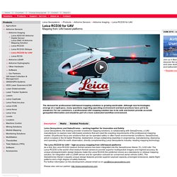
Of particular focus are solutions that can be operated safely in often harsh environmental conditions. SwissDrones, which is based in the St Galler Rheintal, Switzerland, brings outstanding expertise in engineering, manufacturing, deploying and operating UAVs for earth observation, directly complementing Leica Geosystems industry- leading mapping technology.
The Leica RCD30 for UAV – high accuracy mapping from UAV-based platformsAs a first, the Leica RCD30 medium format camera has been integrated into the SwissDrones Waran TC-1235 UAV. The Leica RCD30 is the world’s first medium format camera to provide superior multispectral imagery and highest accuracy. Mapping the World in 3D — with Drones? As controversial as they are, unmanned aerial vehicles (UAVs) are quickly becoming a viable tool in many industries.
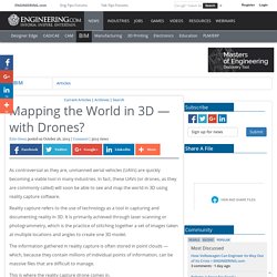
In fact, these UAVs (or drones, as they are commonly called) will soon be able to see and map the world in 3D using reality capture software. Reality capture refers to the use of technology as a tool in capturing and documenting reality in 3D. It is primarily achieved through laser scanning or photogrammetry, which is the practice of stitching together a set of images taken at multiple locations and angles to create one 3D model. The information gathered in reality capture is often stored in point clouds — which, because they contain millions of individual points of information, can be massive files that are difficult to manage. This is where the reality capture drone comes in. These drones are coming for you in 2015 (pictures) Pix4D. DJI - The World Leader in Camera Drones/Quadcopters for Aerial Photography. Phoenix Aerial Systems.
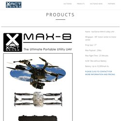
XactSense. Name : XactSense SSP-360 Stable Sensor Platform Version: Currently on V2 Gimbal Drive : High Quality Brushless Gimbal Motors Onboard CPU: 2.0Ghz quad core and Cortex™-A7 quad core CPUs Connectivity: 5.8ghz wifi TCP Sensor options:
NEW RIEGL RiCOPTER VUX-SYS. To use the RiCOPTER for acquisition of high-accuracy, high-resolution laser scan and image data, the UAS is equipped with the RIEGL VUX-SYS, comprising the VUX-1 LiDAR sensor, a IMU/GNSS unit, a control unit, and up to four high-resolution cameras.
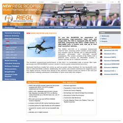
The RIEGL VUX-SYS is a complete miniaturized airborne laser scanning system solution of low weight and compact size for flexible use in UAS/UAV/RPAS, helicopter, gyrocopter and ultra-light aircraft installations. The system consists of the RIEGL VUX-1 airborne laser scanner, an IMU/GNSS system, a control unit and up to 4 optional cameras. The excellent measurement performance of the VUX-1 in combination with a precise fiber optic gyroscope and GPS/GLONASS receiver results in survey grade measurement accuracy. UAV Vermessung & Kartografie /// Vermessungsdrohne : Ascending Technologies GmbH. Bridge inspection & survey. /// Generate georeferenced 2D & 3D information to assess & decide.
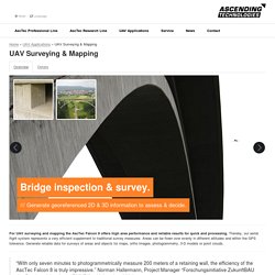
For UAV surveying and mapping the AscTec Falcon 8 offers high area performance and reliable results for quick and processing. Thereby, our aerial flight system represents a very efficient supplement to traditional survey measures. Areas can be flown over evenly in different altitudes and within the GPS tolerance. Generate reliable data for surveys of areas and objects for maps, ortho images, photogrammetry, 3-D models or point clouds. “With only seven minutes to photogrammetrically measure 200 meters of a retaining wall, the efficiency of the AscTec Falcon 8 is truly impressive.” /// Benefit from the technical details. /// The AscTec Falcon 8: A valuable supplement to your existing instruments and devices. The AscTec Falcon 8 will not replace conventional methods; it will rather perfectly complement classic methods. /// Operating everywhere.
VulcanUAV. Drone (UAV) Aerial LiDAR & Surveying.