
Art and architecture sites of interest for Google Maps. Visual History of War, Religion, and Government. Sunrise, sunset, dawn and dusk times around the World - Gaisma. MIRAVI - Meris Image Rapid Visualization [en] Cairns weather radar loop and lightning tracker. 020015ar. Liste des principaux déserts. Un article de Wikipédia, l'encyclopédie libre.
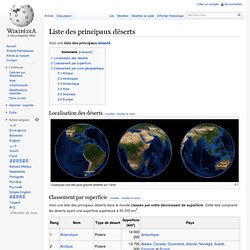
Voici une liste des principaux déserts. Localisation des déserts[modifier | modifier le code] Quelques-uns des plus grands déserts sur Terre. Classement par superficie[modifier | modifier le code] Voici une liste des principaux déserts dans le monde classés par ordre décroissant de superficie. Classement par zone géographique[modifier | modifier le code] Fjords et glaciers vus de l'espace.
Physical geography. Global Site Selector. StatPlanet Map Maker ? Interactive Mapping & Visualization Software. Create a topographic profile. Import file (KML, KMZ, GPX) loaded layer and topographic profile of the route.
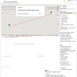
Sometimes, some files do not automatically create a profile! Zoom: 15Counter markers: 2Status: REQUEST_DENIEDАzimuth: 73°Mouse px: ...Lat. /Lon.: ...Center point: -25.343780041796837, 131.03412500000002Center point location: ... How to make a topographic profile? Reset Find your area of interest on the map Select the cursor min. 2 points (max. 300) Ready – site profile will be generated in seconds Embed the chart on your site Copy and save the link to the chart Add the route to the map Program Geocontext-Profiler allows you to make topographic profiles anywhere on Earth in the seabed and ocean floor. Within the program, you can find some advanced options that allow you to create a profile along the road, bicycle and pedestrian paths, and measuring the slope angle.
Location Sites Experiment to Attract Mainstream Users. Still, wariness about broadcasting one’s location extends to city dwellers, too.
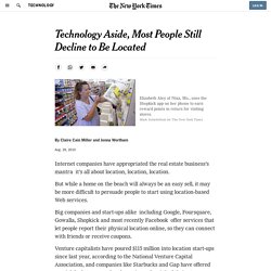
Marsha Collier lives in Los Angeles and writes “For Dummies” books on technology. Google sniffing WIFI to geolocate. Loopt persistant geolocation. Geofencing. San Francisco’s Tsunami Inundation Map (Literally Not Figuratively) at SocketSite™ December 18, 2009 San Francisco’s Tsunami Inundation Map (Literally Not Figuratively) By way of the California Emergency Management Agency, California Geological Survey, and University of Southern California: San Francisco’s Tsunami Inundation Map.
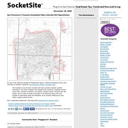
The inundation map has been compiled with best currently available scientific information. The [red] inundation line represents the maximum considered tsunami runup from a number of extreme, yet realistic, tsunami sources. Tsunamis are rare events; due to a lack of known occurrences in the historical record, this map includes no information about the probability of any tsunami affecting any area within a specific period of time.
U.S. Geological Survey Earthquake Hazards Program. FlowingData. GeoCommons. Maponics - Delivering geographic data to drive your business. Ultra Sharp 3D Outdoor and Indoor Maps for Mobile and Home (video. This isn't a photo, it's a 3D map from C3 Technologies.
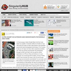
Wow. C3 Technologies makes Google Maps look like it was drawn by a toddler. A Swedish offshoot of SAAB, C3 has ultra sharp 3D maps of major cities based on de-classified government aerial photography technology. C3 isn’t going to sell you its maps, but many other companies probably will. They are actively licensing their 3D photography through an SDK such that it can be used for mobile applications on iPhone, iPad, and Android, or in your computer via a Javascript API for Safari, Chrome, Firefox, and IE. Google Maps, or Bing, and other prominent mapping services out there give you 3D views that look like they were adapted from aerial photographs.
Like many other 3D mapping companies, C3 builds their models by stitching together thousands of aerial photographs. C3 can also produce indoor 3D maps, like this one of the Bellagio Hotel in Las Vegas. As well as increasing its geographic range, C3 is expanding into interior settings. LGBCE - Home. Worldmapper: The world as you've never seen it before. Vous Arnaud Masson from Colomiers ? On passe beaucoup de temps dans des endroits où le gps ne fonctionne pas. Insiteo from Jean Michel Billaut on Vimeo.

(pour ceux qui ne le savent pas, Colomiers se trouve à l'ouest de Toulouse) Phaser (effect) A phaser is an electronic sound processor used to filter a signal by creating a series of peaks and troughs in the frequency spectrum.
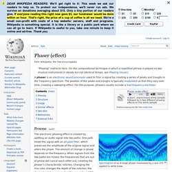
The position of the peaks and troughs is typically modulated so that they vary over time, creating a sweeping effect. For this purpose, phasers usually include a low-frequency oscillator. Spectrogram of an 8-stage phaser modulated by a sine LFO applied to white noise. The electronic phasing effect is created by splitting an audio signal into two paths. One path treats the signal with an all-pass filter, which preserves the amplitude of the original signal and alters the phase.
The Leader In Online Imagery - Aerial Photos & Satellite Images. OpenStreetMap. Heat Maps. Gps indoor. Cartographie. Satelite. Maps & intelligence. Spécialiste en solutions de géolocalisation indoor - Actualités. Your national on-line library for local history.
View from Satellite. NASA Earth Observatory : Home. Animated Manhattan. Web API Reference.