
Science of Acid Mine Drainage Handout. Water Quality. Water Pollution: Acid Mine Drainage: Chemistry Groundwater often flows through the cracks in the crushed sulfides, or sulfur-rich minerals, that remain after an area has been mined.
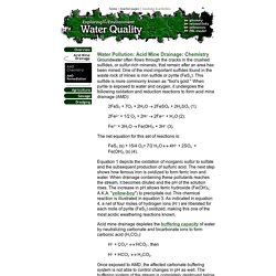
One of the most important sulfides found in the waste rock of mines is iron sulfide or pyrite (FeS2). This sulfide is more commonly known as "fool's gold. " When pyrite is exposed to water and oxygen, it undergoes the following oxidation and reduction reactions to form acid mine drainage (AMD): Water Quality. Water Pollution: Acid Mine Drainage Acid mine drainage (AMD) is generally a non-point-source water pollutant.
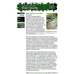
It is the acidic water that drains out of above-ground or under-ground coal and metal mines. Acid mine drainage impacts stream and river ecosystems by increasing acidity, depleting oxygen, and releasing heavy metals such as aluminum (Al3+), iron (Fe3+), manganese (Mn2+), and zinc (Zn2+). Green Streets Basics and Design. BMPs to Programs The evolution from centralized stormwater management to greener, more sustainable BMPs necessitates a progression from installing individual practices to implementing broader water quality programs.
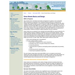
Conventional end-of-pipe management practices are often installed myopically, focused primarily on collecting runoff from one drainage area. The first applications of stormwater BMPs were similarly applied, focused on addressing runoff from a small area. Ws ourwater california state fact sheet. Martin Riese & Michael Mascha The waters from Netflix: Down to Earth with Zac Efron. Fine Water ACADEMY - FineWaters. Green Streets, Green Jobs, Green Towns (G3) Program. What are green street practices?
Green street practices are select green infrastructure elements, such as bioswales, rain gardens, and permeable pavement, that can be incorporated into a traditional street design to create a "Green Street". Green street practices capture, retain, treat, and/or infiltrate stormwater runoff from impervious surfaces such as roadways, parking lots, sidewalks, and rooftops. Hydrothermal Features - Yellowstone National Park. Color often provides a clue as to which organisms are living in hydrothermal features.

A: Green non-sulfur bacteria (Chloroflexus) or ArchaeaB: Deinococcus-Thermus (Thermus aquaticus)C: Cyanobacteria (Synechococcus)D: Cyanobacteria (Phormidium)E: Cyanobacteria (Calothrix) This in turn can offer a clue as to the temperature of the water (because thermophiles tend to live in specific ranges of temperature).
How acidic or basic the water is also plays a role in what organisms can live in it. This is measured by the pH scale. Hydrothermal Features - Yellowstone National Park. Aqueduct Subsidence Program. Subsidence and the SWP Aqueduct The California Aqueduct, built and maintained by DWR, delivers water to 27 million people throughout the state.
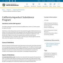
Subsidence, or the sinking of land, has been documented throughout California for almost a century. Prior to the construction of the aqueduct in the mid-1960s, portions of land near the aqueduct dropped between 20 and 30 feet. Gicima. : Volcano Hazards Program. Interferogram image made from InSAR monitoring, showing 1995-2001 ground-uplift pattern centered 5 km (3 mi) west of South Sister volcano, Oregon.
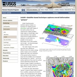
(click for more info) Yellowstone ground movement map from Sept 2004 - Aug 2006. InSAR (Interferometric Synthetic Aperture Radar) is a technique for mapping ground deformation using radar images of the Earth's surface that are collected from orbiting satellites. Unlike visible or infrared light, radar waves penetrate most weather clouds and are equally effective in darkness. Earth on Nautilus: The Sinkhole Hunters. One day in May 2014, a muddy truck bound down a dirt road through the backwoods of Gainesville, Florida.

It pulled up in a cloud of dust to a sprawling green farmhouse with a wide front porch, nestled among cypress trees dripping in gray Spanish moss. Horses ate from hay bales in a small stable. Situated on four acres of pasture and woods, the house was a place to spend a day in a rocking chair, sipping from a tall cold glass of sweet tea.
But the owner, Bill Baxter, a graying, retired hospital administrator with a thick Southern accent, was sweating, and not because of the heat. Baxter guided the men in the truck through his backyard and told them of the scare he’d had the other day. He had reason to be wary. “Last time I checked, the constitution lets you move where you want to move. Water Education Foundation - Everything about California water that matters. Well Owner Lessons – Wellowner.org. Click here to access short, free online lessons about water well and water quality issues.
Sinkhole swallows two homes in Land O' Lakes neighborhood; cleanup could take months. LAND O' LAKES, Fla.

Sinkhole swallows two homes in Land O' Lakes neighborhood; cleanup could take months. Sinkhole swallows two homes in Land O' Lakes neighborhood; cleanup could take months. Engineers: Let the Land O'Lakes sinkhole reconnect with Lake Padgett. LAND O’LAKES, Fla. – A seventh home was condemned on Monday due to a growing sinkhole that scientists say could be trying to connect with Lake Padgett. “We have had a lot more activity over the weekend, and cracking in some of these foundations,” Pasco County Spokesman Doug Tobin said. “We think it's probably the aggravation of existing depressions.” The shape of the sinkhole, which led to four homes being condemned over the weekend, might explain why it’s been so unpredictable, according to engineers from the University of South Florida.
8th home condemned near massive Land O’ Lakes sinkhole. LAND O’ LAKES, Fla. (WFLA) — Another home near the site of last month’s massive sinkhole in Land O’ Lakes has met criteria for demolition. On Monday, Pasco County officials announced a home on Canal Place was condemned Friday. It’s the same home that 8 On Your Side told you about last week, when the family who lived there said they were worried their home had not yet been condemned. The family moved out voluntarily at the time. There are now eight homes total near the site of the sinkhole that have met criteria for demolition, including the two homes that were originally swallowed and destroyed. Alviso EIA11 Sheet 061515 BA. Where Does Your Water Come From? - Santa Clara Valley Water District.
Local water Groundwater and local surface water is the county’s original source of water supply. Local rainfall and runoff flows into reservoirs for storage and blending with imported water. The water is released into creeks and ponds to augment natural percolation and maintain groundwater levels. Solar paint offers endless energy from water vapor: Compound catalyses splitting of water molecules. Researchers have developed a solar paint that can absorb water vapour and split it to generate hydrogen -- the cleanest source of energy.
The paint contains a newly developed compound that acts like silica gel, which is used in sachets to absorb moisture and keep food, medicines and electronics fresh and dry. But unlike silica gel, the new material, synthetic molybdenum-sulphide, also acts as a semi-conductor and catalyses the splitting of water molecules into hydrogen and oxygen. Lead researcher Dr Torben Daeneke, from RMIT University in Melbourne, Australia, said: "We found that mixing the compound with titanium oxide particles leads to a sunlight-absorbing paint that produces hydrogen fuel from solar energy and moist air. "Titanium oxide is the white pigment that is already commonly used in wall paint, meaning that the simple addition of the new material can convert a brick wall into energy harvesting and fuel production real estate.
Drought Has Disappeared from Much of the U.S. : Image of the Day. Bioswales for Stormwater Management. Do you live in a community with expansive impermeable parking lots or on a street with dirt or grass along the sidewalk? These designs are known for being ineffective at absorbing the runoff from rainstorms. Bioswales may be a viable solution for your area.
Bioswales are used as an alternative to storm sewers and are becoming increasingly common in urban areas–alongside roads, sidewalks, and in parking lots. Science, Engineering & Technology. 556e2e59 2d5c 47c9 b108 d619ca2e331a. San Joaquin Valley is Still Sinking. Since the 1920s, excessive pumping of groundwater at thousands of wells has caused land to subside, or sink, by as much as 8.5 meters (28 feet) in sections of California’s San Joaquin Valley. This subsidence is exacerbated during droughts, when farmers rely heavily on groundwater to sustain one of the most productive agricultural regions in the United States. Subsidence is a serious and challenging concern for California’s water managers, putting state and federal aqueducts, levees, bridges and roads at risk of damage. Already, long-term land subsidence has damaged thousands of public and private groundwater wells throughout the San Joaquin Valley.
Furthermore, the subsidence can permanently reduce the storage capacity of underground aquifers, threatening future water supplies. It’s also expensive. Drinking Water & Ground Water Kids' Stuff. Building a Model Aquifer PDF (2pp, 256K) - Step by step instruction on building your own aquifer. Strokkur Geyser in Iceland - EPOD - a service of USRA.
Photographer: Jim BuckoSummary Authors: Jim Bucko; Jim Foster Shown above is the Strokkur geyser in the southwest of Iceland. The word geyser is from the Old Norse meaning to rush forward or gush. Water Cycle - Earthguide Animated Diagram. Groundwater - flash animated diagram. Cave Conundrum. Aquifer in a tank, An Earth-Science Experiment.