GIS Programming: Languages breakdown. A while back, I wrote a post on Learning GIS Programming, giving an overview of the different programming languages being used in GIS.
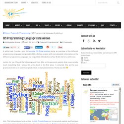
A follow-up post with more detailed information on the different programming languages has languished at the bottom of my To-Do list for a while now. Luckily for me, I found the following post from Atle on his personal website that covers pretty much everything that I wished to write about in the first place. I contacted Atle and he was graciously to let us re-post his original article on Geoawesomeness. Thank you Atle Info: The following post was written by Atle Frenvik Sveen on his personal website and has been re-posted under Creative Commons.
The famous algorithm that made navigation in Google Maps a reality. Home / Navigation / The famous algorithm that made navigation in Google Maps a reality Dijkstra: The man who made digital navigation a reality.
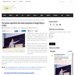
Copyright: Andreas F. Borchert Wikipedia Google Maps is arguably one of the most famous Geospatial applications ever. Overnight, it transformed the way we navigate and made it mainstream to use a digital map to get from Point A to Point B. Philippe Estèbe - Le site de l'Ihedate. Mining the Social Web, 2nd Edition - O'Reilly Media. This book uses, at its core, a couple of services to permit the reader to do code experiments using pre-written Python modules in a specially packaged format.
The idea is that you install the two services required and then you can experiment to your heart's content with the code. The Problem. Bienvenue à toi, voyageur du code ! - Voyageurs du code. Geospatial developement simplified with python. In this article I am going to show how easy it is to build a real world Geo-spatial application with python.
What is Geospatial development or Geographical Information Systems (GIS)?. According to Wikipedia , Geographical information systems (GIS), which is a large domain that provides a variety of capabilities designed to capture, store, manipulate, analyze, manage, and present all types of geographical data, and utilizes geospatial analysis in a variety of contexts, operations and applications. Basic Applications. How JavaScript & mapping works.
There are a lot of ways to learn JavaScript on the web.
You can use specific guides like Codecademy or Eloquent JavaScript. Or you can make maps. In this guide, we’ll introduce you to JavaScript basics and how you can use them when building a map with Mapbox.js. JavaScript basics Variables. Learning GIS programming: An overview. The diversity of programming languages and tools being used in the Geospatial industry today is truly staggering.
Depending on what the position requires, one would be expected to have expertise in SQL, python, C++, Java or Javascript, Flex and PHP (just to name a few). Knowledge and competence in programming is a essential skill set and a critical requirement for most Geospatial job opportunities these days. A vast majority of job openings in the Geospatial industry require some expertise in programming, application development and software management. As Geospatial professionals/graduates/students, some of us overlook the importance of programming in our careers. Some of us believe that our spatial skill sets are niche enough to compensate for the lack of our programming expertise. Mbostock/topojson. #Code : La révolution Programmée. D'un langage de spécialiste, à un langage accessible par tous, le code devient un "super pouvoir" capable de décupler la créativité, bouleverser les industries et transformer la société.
D'un langage de spécialiste, à un langage accessible par tous, le code devient un "super pouvoir" capable de décupler la créativité, bouleverser les industries et transformer la société. Outil d'innovation, de prototypage et d'accélération par excellence, le code semble devenu la botte secrète des start-ups. Nouveau langage, le code serait-il la grammaire 2.0 que tout écolier doit connaître pour développer son esprit critique à l'heure du numérique ? Nouveau paradigme économique, le code façonnera nécessairement les entreprises de demain en les transformant en de réelles organisations du XXIème siècle : des organisations programmables. Statistiques Vues Total des vues Vues sur SlideShare.
Cmichi/gtfs-visualizations. 10 Open-Source Projects Every JavaScript Geo Dev Should Know About. An article flew by in my Twitter stream, with the title “10 Open-Source Projects Every #JavaScript Geo Dev Should Know About”.
As I consider myself a Javascript Geo Dev i thought that there might be som OpenSource gems I’ve missed and clicked the link. The link brought me to esri.com and what I was presented with was this article, listing 10 open source javascripts projects that I’ve never heard of. Calculate distance and bearing between two Latitude/Longitude points using Haversine formula in JavaScript. Welcome to Python.org. Spatial research and data visualisation. Learn R interactively with the swirl package. Leaflet.js - introduction. Introduction for @JSLuxembourg By Thierry Nicola / eevol.lu / @littleiffel Disclaimer No Kittens where harmed in the creation of these slides.
6 Reasons to Get Over Your Fear of Coding and Start Making Better Maps - Wired Science. The web has changed so many things that we can be forgiven for developing callouses on whatever part of our brain controls amazement.
But reminisce for a moment, back to a time when you had to buy maps, pay for directions, and if you wanted to create new views of the world, you needed access to some combination of patience, mathematical expertise, and expensive technology. Mapping, GIS, QGIS & MapBasic. Planetary.js: Awesome interactive globes for the web. Alyssa frazee. Thu 02 January 2014 | -- (permalink) My sister is a senior undergraduate majoring in sociology. She just landed an awesome analyst job for next semester and was told she'll be using some R in the course of her work. She asked me to show her the ropes during winter vacation, and of course I said yes! Tutorials · mbostock/d3 Wiki. Wiki ▸ Tutorials Please feel free to add links to your work!! Tutorials may not be up-to-date with the latest version 4.0 of D3; consider reading them alongside the latest release notes, the 4.0 summary, and the 4.0 changes.
Introductions & Core Concepts Specific Techniques. D3.js Tutorials, Screencasts and a Newsletter. Python. Le guide ultime et définitif sur la programmation orientée objet en Python à l’usage des débutants qui sont rassurés par les textes détaillés qui prennent le temps de tout expliquer. Partie 1. Prérequis à ce tuto bien chargé : comprendre parfaitement les mots clés les plus courants (conditions, tests, pass, etc);comprendre parfaitement les fonctions (et donc les paramètres avancées en Python);comprendre la notion de référence;connaitre les structures de données de base (string, int, list, dict, etc).
Pysal - Python Spatial Analysis Library. PySAL is an open source cross-platform library of spatial analysis functions written in Python. It is intended to support the development of high level applications for spatial analysis. PySAL development has moved to GitHub.