
Hypercities Earth. Gallery. Gallery. Untitled. Untitled. Major Agglomerations of the World - Population Statistics and Maps. Definition: Urban agglomerations include a central city and neighboring places mostly linked by (more or less) continuously built-up areas.
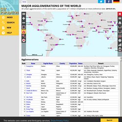
Some agglomerations have more than one central city (e.g., "The Ruhr"). Data: The presented population figures are projected according to the previous development to the given reference date. Official censuses and estimations are mostly the basis of this computation. The delimitation and composition of urban agglomerations is often defined or modified by »City Population« in order to increase comparability. World database of large urban areas, 1950-2050. File:Union Square.jpg. File:View of Woolworth Building fixed.jpg. Streetscape showing the London Pavilion across Piccadilly Circus, circa 1910 - The Theatres Trust. File:Frankfurt Altstadt-Markt Kanalbau.jpg. File:English School, 19th Century, Snow Hill, Holburn, London.jpg. File:DPPA Gas Production Platform - Morecambe Bay, off Lancashire, UK.jpg. File:Balakhany oil.jpg. File:Carload of coal at the tipple. P V & K Coal Company, Clover Gap Mine, Lejunior, Harlan County, Kentucky. - NARA - 541395.jpg.
File:Frond, Bachelier - Aqueduto da Carioca (Arcos da Lapa).jpg. File:Agriculture (Primitive) CNE-v1-p58-I.jpg. Glen Canyon Dam. File:Cottonopolis1.jpg. File:Philipp Jakob Loutherbourg d. J. 002.jpg. Untitled. Beijing. Beijing, formerly Peking, is the capital of the People's Republic of China and one of the most populous cities in the world.
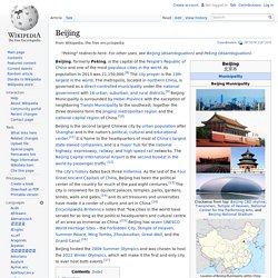
Its population in 2013 was 21,150,000.[8] The city proper is the 13th largest in the world. The metropolis, located in northern China, is governed as a direct-controlled municipality under the national government with 16 urban, suburban, and rural districts.[9] Beijing Municipality is surrounded by Hebei Province with the exception of neighboring Tianjin Municipality to the southeast; together the three divisions form the Jingjinji metropolitan region and the national capital region of China.[10] Beijing is the second largest Chinese city by urban population after Shanghai and is the nation's political, cultural and educational center.[11] It is home to the headquarters of most of China's largest state-owned companies, and is a major hub for the national highway, expressway, railway, and high-speed rail networks.
Etymology[edit] History[edit] Early history[edit] Procession of the True Cross in Piazza San Marco, Venice. The work Gentile's Procession gives us a fairly accurate picture of what Piazza San Marco looked like in the late 15th century, before the Byzantine buildings were replaced in the early 16th century by the Procuratie Vecchie and their 50 arcades, and before it was remodeled by Napoleon, who introduced the Ala Napoleonica.
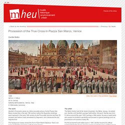
The background clearly shows the front of Saint Mark's Basilica—then a lot more colorful than it is today—with its green domes. Untitled. Jaisalmer Fort. Jaisalmer Fort is one of the largest fortifications in the world.
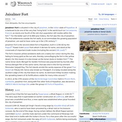
It is situated in the city of Jaisalmer, in the Indian state of Rajasthan. It is a World Heritage Site. It was built in 1156 AD by the Rajput ruler Rawal Jaisal, from whom it derives its name. (Rawal Jaisal's son was Shalivahan II; Manj and Bhati Rajputs are descended from him.) Teotihuacan: Cidade dos deuses. Quem visita hoje Teotihuacan, situada a 45 km da atual Cidade do México, admira-se ao perceber, em suas ruínas, a imponência da civilização que lá vivia.
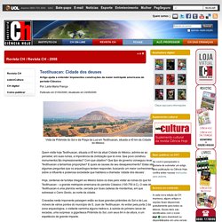
Que povo construiu monumentos tão impressionantes? Com que objetivo? Que tipo de governo conseguiu levar Teotihuacan a tamanhas proporções? E quais as causas de seu desaparecimento? Estas são algumas perguntas que os arqueólogos tentam responder, buscando um maior conhecimento sobre a influente e poderosa sociedade que habitava a chamada ‘cidade dos deuses’. Hoje, centenas de turistas chegam ao México todos os dias para visitar as ruínas do que foi Teotihuacan – a grande metrópole americana do período Clássico (100-750 d.C). Redirect Page. Ur. Origem: Wikipédia, a enciclopédia livre.
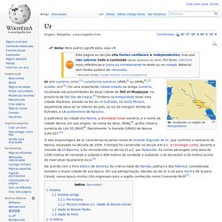
O sítio arqueológico de Ur caracteriza-se pelas ruínas do Grande Zigurate de Ur, que continha o santuário de Nanna, escavado na década de 1930. O templo foi construído no século XXI a.C. (cronologia curta), durante o reinado de Ur-Nammu, e foi reconstruído no século VI a.C. por Nabonido. As ruínas abrangem uma área de 1200 metros de noroeste a sudeste e 800 metros de nordeste a sudoeste, e se elevavam a 20 metros acima do nível atual da planície local.[6] De acordo com o livro bíblico de Génesis, foi a terra natal de Abraão, patriarca dos hebreus, considerada também a maior cidade de sua época.
História[editar | editar código-fonte] História antiga[editar | editar código-fonte] Teotihuacan: Cidade dos deuses. Untitled. Redirect Page. Preview007. PremiumSale.com Premium Domains. Çatalhöyük ‘Map’ Mural May Depict Volcanic Eruption 8,900 Years Ago. A new study published in the journal PLOS ONE suggests a mural excavated at the Neolithic site of Çatalhöyük in Central Anatolia, Turkey, may be based on the eruption of the nearby twin-coned volcano Mount Hasan around 6900 BC.
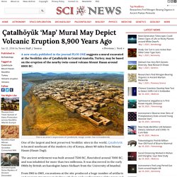
This is an artist’s impression of Çatalhöyük. Image credit: Dan Lewandowski. One of the largest and best preserved Neolithic sites in the world, Çatalhöyük is located southeast of the modern city of Konya, about 90 miles from Mount Hasan (Hasan Dagi). The ancient settlement was built around 7500 BC, flourished around 7000 BC, and was inhabited for more than two millennia. It was discovered in the early 1960s by British archaeologist James Mellaart from the University of Istanbul.