
Viabundus Pre-modern street map. Welcome to Viabundus!
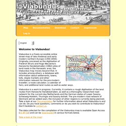
Viabundus is a freely accessible online street map of late medieval and early modern northern Europe (1350-1650). Originally conceived as the digitisation of Friedrich Bruns and Hugo Weczerka's Hansische Handelsstraßen (1962) atlas of land roads in the Hanseatic area, the Viabundus map moves beyond that. It includes among others: a database with information about settlements, towns, tolls, staple markets and other information relevant for the pre-modern traveller; a route calculator; a calendar of fairs; and additional land routes as well as water ways.
Viabundus is a work in progress. Currently, it contains a rough digitisation of the land routes from Hansische Handelsstraßen, as well as a thoroughly researched road network for the current-day Netherlands and the German states of Lower Saxony, Schleswig-Holstein, Thuringia and Saxony-Anhalt. Take a look at the map! Documentation Latest version (1.0) Other documentation files Download Contact Blog and Twitter. Digital Mappa. ANCIENT MAPS 6,200 BC to 600 A.D. 21 Monographs 180 images. Renaissance Maps 1492-180058 Monographs700 Images About this Site If you have specific questions or comments about this site, or would like a copy of these monographs and images on CD/DVD you can contact me at: jsiebold@me.com My alternative and more up-to-date web site is located at: www.myoldmaps.com I want to thank Henry Davis Consulting for hosting this site for the past 15 years.
Chart Room - Kaartenkamer. Historic Towns Atlas. Peutinger map seamless whole, in color, with overlaid layers. Peutinger map: seamless whole, in color, with overlaid layers (Map A) Click here to launch viewer The viewer may be resized or closed after launch.
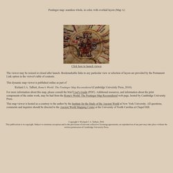
Bookmarkable links to any particular view or selection of layers are provided by the Permanent Link option in the viewer's table of contents. This dynamic map viewer is published online as part of Richard J.A. For more information about this map, please consult the brief User's Guide (PDF). This map viewer is hosted as a courtesy to the author by the Institute for the Study of the Ancient World at New York University. Copyright © Richard J. Permanent link to current view. History of Cartography: Volume One in PDF. Outils et ressources cartographiques. MAPS: The Medieval Association of Place and Space. Gough Map of Great Britain: an interactive, searchable edition, contextual material, blog, and information about Linguistic Geographies project History of Cartography, Volume One: Cartography in Prehistoric, Ancient, and Medieval Europe and the Mediterranean, ed.
J. B. Harley and David Woodward (Chicago, IL: University of Chicago Press, 1987): A free full-text version of the multi-volume set with volume one the most relevant: 622 pages, 32-page color insert, 40 color plates, 240 halftones John Harding, map of Scotland, ca. 1450: British Library, Lansdowne MS 204. Stedenatlas De Wit. Biblioteca Nazionale Marciana - Venezia. Pagina di benvenuto. Historical Maps Overview. Paleogeografische kaarten. In het verleden zag het landschap van Nederland er totaal anders uit.
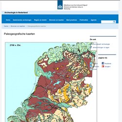
De paleogeografische kaarten uit de Atlas van Nederland in het Holoceen (2011) maken inzichtelijk hoe het Nederlandse landschap er gedurende de laatste 10.000 jaar heeft uitgezien. De twaalf kaarten zijn recentelijk vernieuwd door P. Vos en S. de Vries (Deltares): 2e generatie plaeogeografische kaarten van Nederland (versie 2.0). Paleogeografische kaarten geven een oude geografische situatie weer. Het zijn momentopnames; ze laten zien hoe op een bepaald moment het landschap van Nederland er waarschijnlijk uitzag.
Archaeology in Europe - Early Medieval Emporia: Distribution Map. Medieval_index. Map Collections Home Page. The Library of Congress Search by Keyword | Browse by Geographic Location Index | Subject Index | Creator Index | Title Index The Geography and Map Division of the Library of Congress holds more than 4.5 million items, of which Map Collections represents only a small fraction, those that have been converted to digital form.

The focus of Map Collections is Americana and Cartographic Treasures of the Library of Congress. These images were created from maps and atlases and, in general, are restricted to items that are not covered by copyright protection. Map Collections is organized according to seven major categories. Atlas der Neederlanden. Maps § Digital Atlas of Roman and Medieval Civilization. DMMapp - Digitized Medieval Manuscripts App. What is the DMMapp?
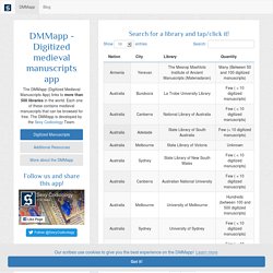
The DMMapp is an open source app that links to digital repositories containing digitized western medieval manuscripts from all over the world. Finding digitized repositories can be difficult, and we want to create a central hub that can help medievalists, codicologists, and enthusiasts to find the medieval manuscripts they are searching for. Who made the DMMapp? The DMMapp is a project by Giulio Menna, MA, and Marjolein de Vos, MA. We are the Sexy Codicology Team. I love the DMMapp! Contribute to the DMMapp If you are aware of a library that is not on our DMMapp, you can use the "Add a Missing Library" form to let us know. I would like to base a project on the DMMapp! Old Maps Online. View Collection. The BRITISH HISTORIC TOWNS ATLAS. Basicmodule. Module Number: EU19 Module Name: The Formation of the Italian Nation.
MoEML: The Map of Early Modern London. Electronic Atlas of Industrialising Britian : Contents. History and Geography of Europe. Hist-geo.co.uk.