
USGS Scientific Investigations Map 3316: Image Mosaic and Topographic Map of the Moon. Map Descriptions Sheet 1: This image mosaic is based on data from the Lunar Reconnaissance Orbiter Wide Angle Camera (WAC; Robinson and others, 2010), an instrument on the National Aeronautics and Space Administration (NASA) Lunar Reconnaissance Orbiter (LRO) spacecraft (Tooley and others, 2010).
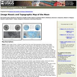
The equatorial WAC images were orthorectified onto the Global Lunar Digital Terrain Mosaic (GLD100, WAC-derived 100 m/pixel digital elevation model; Scholten and others, 2012) while the polar images were orthorectified onto the lunar LOLA polar digital elevation models (Neumann and others, 2010). The Mercator projection is used between latitudes ±57°, with a central meridian at 0° longitude and latitude equal to the nominal scale at 0°. The Polar Stereographic projection is used for the regions north of the +55° parallel and south of the –55° parallel, with a central meridian set for both at 0° and a latitude of true scale at +90° and -90°, respectively. HISTOIRE DE FRANCE - L'histoire de France en cartes. La présence humaine sur le territoire de la France actuelle remonte d’il y a environ 1 800 000 ans.
L’homme est alors confronté à un climat rude marqué par plusieurs ères glaciaires. Vers -10 000, à la fin de la dernière ère glaciaire, le climat s’adoucit et partir de -7 000 environ ses habitants se sédentarisent avec l'apparition progressive de la culture des céréales, de l'élevage, de la métallurgie et de nouvelles techniques artisanales: poterie, tissage, polissage...
Les premiers villages apparaissent ainsi que les premiers tombeaux mégalithiques : tumulus, cairns, dolmens, et menhirs. Cartographie interactive - webmapping - statistiques - carte de France - atlas - Géoclip. Maps - All The Worlds Maps - A Compilation of Each Nation's Maps - Including State Maps. Map Index - Atlapedia® Online.
The World Factbook. People from nearly every country share information with CIA, and new individuals contact us daily.
If you have information you think might interest CIA due to our foreign intelligence collection mission, there are many ways to reach us. If you know of an imminent threat to a location inside the U.S., immediately contact your local law enforcement or FBI Field Office. For threats outside the U.S., contact CIA or go to a U.S. Embassy or Consulate and ask for the information to be passed to a U.S. official.
Please know, CIA does not engage in law enforcement. In addition to the options below, individuals contact CIA in a variety of creative ways. If you feel it is safe, consider providing these details with your submission: Your full name Biographic details, such as a photograph of yourself, and a copy of the biographic page of your passport How you got the information you want to share with CIA How to contact you, including your home address and phone number. MapMaker Interactive.
Welcome to the MapMaker Interactive This tutorial explains how to explore National Geographic Education's interactive GIS mapping tool and tools for customizing outline maps for print.

Use the zoom bar to go from a world view to a local view (or in cartographic terms, from a large scale to a small scale). If you zoom out to a world view, you will see that the map is in a Mercator projection. Use the location menus at the top to zoom from a world view to a continent, country, or other region. Identify your geographic position on the map using the latitude and longitude display at the bottom left. Fonds de cartes gratuits. Trois formats vectoriels pour une impression plus précise des tracés et un redimensionnement sans altération de la qualité de l'image : PDF, ODG et EMF. World Sites Atlas - maps, hotels, destination guides, facts, links, photos, and more. World Map, Map of the World. Maps of Continents - Geographic Guide Travel.
World Atlas including Geography Facts, Maps, Flags - worldatlas.com. Map Index. Cartes-Atlas-Plans de villes. History and Geography of Europe.
Geographic.org home page - Geography, climate, countries, Maps, Flags, Population. Le Monde diplomatique. MapQuest Maps - Driving Directions - Map.