
Estadísticas mundiales en tiempo real. Mapa en tiempo real de ataques informáticos. Estadísticas mundiales en tiempo real. POODWADDLE WORLD CLOCKThe World Stats Counter (V 7.0) This minute 250 babies will be born, 100 people will die, 20 violent crimes will be reported, and the US debt will climb $1 million.

The World Clock tells more than time. It shows a live picture of our changing world. The World Clock is too large for a single page. It had to be divided into multiple categories. You can rotate the map by dragging left or right or by clicking the left and right buttons on the menu. The menu provides several filter options. We show two types of stats:1. Cable submarino 2013. Mapa Mundial de Fotos - imagenes. Mapa Mundial de Fotos - imagenes - Colombia. Home Jump to or earth album - Colombia earth album is a simpler, slicker Flickr mash-up that allows armchair tourists to explore some of the most stunning photos in the world courtesy of Google maps and Flickr.
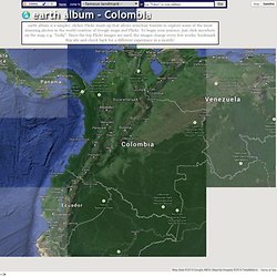
To begin your journey, just click anywhere on the map, e.g. "India". Since the top Flickr images are used, the images change every few weeks; bookmark this site and check back for a different experience in a month! Time Magazine Top 10 Website of 2006 ∞ PC Magazine Top 100 Undiscovered Websites ∞ front page of digg Jump to. Detectores de radiación radiactividad. Localizador de huracanes, ciclones y tormentas. Red Mundial de Sismografia. Servicio de Información sobre Desastres y Emergencias.
Localizador de sismos. Conflictos Historicos Mundiales. Mapa amenaza cibernética. Las 50 ciudades más violentas del mundo. Niveles de contaminacion - tasas de CO2, de nacimiento y de muerte por país, simuladas en tiempo real. Niveles de contaminacion.
Mapa Brotes de enfermedades prevenibles por Vacunacion. This interactive map visually plots global outbreaks of measles, mumps, whooping cough, polio, rubella, and other diseases that are easily preventable by inexpensive and effective vaccines.
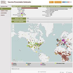
Red triangles indicate attacks on vaccinators and healthcare workers, as well as announcements from both governments and non-state actors that have had an impact—either positive or negative—on the successful implementation of vaccination programs. The Global Health Program at the Council on Foreign Relations has been tracking reports by news media, governments, and the global health community on these outbreaks since the fall of 2008. This project aims to promote awareness of a global health problem that is easily preventable, and examine the factors that threaten the success of eradicating preventable illnesses such as polio. Learn more about Global Health. On to the Vaccine-Preventable Outbreaks map. Informacion desastres naturales.
Localizacion instalaciones amenaza nuclear. Hide The nuclear, chemical, biological, and missile facilities depicted in this map correspond to content found in the NTI country profiles.
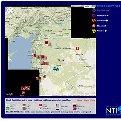
Please see this content for further information and sources. Since definitive information on countries' NBC and missile facilities is often classified, the descriptions and mapped locations of these facilities are sometimes speculative, based on the most credible available open source material. This material is produced independently for NTI by the James Martin Center for Nonproliferation Studies at the Monterey Institute of International Studies and does not necessarily reflect the opinions of and has not been independently verified by NTI or its directors, officers, employees, or agents.
Copyright © 2011 by MIIS. Hallazgos de Meteoritos. Nivel CO2, natalidad y las tasas de mortalidad por país, simulacion en tiempo real. Centro de informacion de alteraciones climaticas.