
Kansas River. Kansas River: Midwestern Secret It can get downright hot in The Sunflower State.
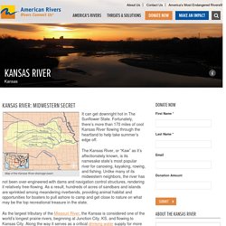
Fortunately, there’s more than 170 miles of cool Kansas River flowing through the heartland to help take summer’s edge off. The Kansas River, or “Kaw” as it’s affectionately known, is its namesake state’s most popular river for canoeing, kayaking, rowing, and fishing. Unlike many of its midwestern neighbors, the river has not been over-engineered with dams and navigation control structures, rendering it relatively free-flowing.
As a result, hundreds of acres of sandbars and islands are sprinkled among meandering riverbends, providing animal habitat and opportunities for boaters to pull ashore to camp and get close to nature on what may be the top recreational treasure in the state. GIS Maps - Kansas River Inventory. In-River - Who and Where - Friends of the Kaw.
Bonner Springs, KS - Official Website. Dredging. Glaciers in Kansas. Kansas Geological Survey, Public Information Circular (PIC) 28 A complete text of this file is available as a pdf document.
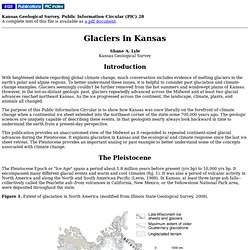
Shane A. Lyle Kansas Geological Survey Introduction With heightened debate regarding global climate change, much conversation includes evidence of melting glaciers in the earth's polar and alpine regions. To better understand these issues, it is helpful to consider past glaciation and climate-change examples. The purpose of this Public Information Circular is to show how Kansas was once literally on the forefront of climate change when a continental ice sheet extended into the northeast corner of the state some 700,000 years ago. This publication provides an unaccustomed view of the Midwest as it responded to repeated continent-sized glacial advances during the Pleistocene.
The Pleistocene The Pleistocene Epoch or "Ice Age" spans a period about 1.8 million years before present (yrs bp) to 10,000 yrs bp. Figure 1. Figure 2. What Caused the Glaciers? GIS Data North America. Q&A: Understanding frac sand with Minn.'s Chief Geologist. Dredging companies forced to look toward dry land. Kansas Canoe and Kayaking Association. Douglas County, Kansas - GIS Map Viewer. Douglas County, Kansas - GIS Map Viewer. GIS Maps - Kansas River Inventory. Kansas Free GIS Data. Water Resources: Maps and GIS Data.
Kansas Data Access and Support Center - Your resource for geospatial data from the State of Kansas. Water Resources. New Geological Survey Online Atlas Underscores Water Concerns in Kansas New Open-file Report 2012-16, Statistical and Geostatistical Analysis of the Kansas High Plains Water-Table Elevations, 2012 Measurement Campaign , by Geoffrey Bohling and Brownie Wilson New Open-file Report 2012-3, Ground-Water Model for Southwest Kansas Groundwater Management District No. 3: Future Scenarios , by Gaisheng Liu, Brownie Wilson, Donald O. Whittemore, and James J. Butler, Jr. Barometric Response Function Software --The KGS Barometric Response Function Software computes a function describing the influence of barometric (atmospheric) pressure variations on water levels in wells and uses that function to filter atmospherically induced fluctuations from observed water levels. WWC5 search for Water Well Completion forms has a renovated online mapping system linked to each well.
Public Information Circular 18--The High Plains Aquifer , by Rex C. Kansas river. Kvha2map.jpg (1350×795) Missouri River Sand and Gravel Dredging, September 2010. September 2010 Missouri River Sand and Gravel Dredging This fact sheet will assist you in understanding the EPA Region 7 action on a proposal to allow sand and gravel removal from the Missouri River. The proposal would allow the removal of 11.6 million tons per year of main channel river bottom material. What is the federal action? The U.S. The issuance of these permits is a federal action requiring analysis of the environmental impact of this action under the National Environmental Policy Act (NEPA). Where is dredging occurring? River Mile 498 at Rulo, Neb., to River Mile 0 at St. Why is EPA taking this action? MT = million tons What environmental concerns justify EPA's ratings? Loss of sediment in the Missouri River (by many factors including dredging) results in: 1.
Lowered sediment concentrations in the River causes an increased erosion effect especially on levee toes, which increases their risk of structural failure. What will happen next? Are information needs likely to be met? Kansas River Corridor. Chapter 2 of The Kansas River Corridor--Its Geologic Setting, Land Use, Economic Geology, and Hydrology David A. Grisafe, Kansas Geological Survey Limestone Resources Current and Potential Uses The Kansas River has cut through many limestones, shales, clays, and occasional sandstones of Upper Pennsylvanian age in the lower or eastern portions of the valley and Lower Permian age in the upper or western portions of the valley.
During early highway-construction projects, most limestones along the river corridor were used for aggregate. Within the Kansas River corridor, crushed limestone was once the major ingredient in the production of cement at the Lone Star cement plant near Bonner Springs. Limestone could be a potential substitute for sand and gravel. Current and Potential Sources Only certain limestone beds are used for crushed stone. Kansas River Corridor. Chapter 1 of The Kansas River Corridor--Its Geologic Setting, Land Use, Economic Geology, and Hydrology James R.
Www.garden-city.org/DocumentCenter/View/798. 13024u - Ethnography Outline. Reports & Publications - Kansas Water Office. The Kansas Water Office prepares reports to inform the Governor, Kansas Legislators, government officials, and the citizens of Kansas of the status of water policy, programs and water issues in Kansas. Kansas Drought Operations Plan - Governor's Drought Team - Executive Order No. 12-09 - This operations plan is intended to provide the Governor's Drought Team with an effective and systematic means of monitoring drought conditions and implementing appropriate response actions to limit the adverse impacts of drought. Kansas Sand and Concrete, Inc. What does dredging reach mean? Www.nwk.usace.army.mil/Portals/29/docs/regulatory/ksdredging/KSRiverHistoryAnalysis.pdf.