
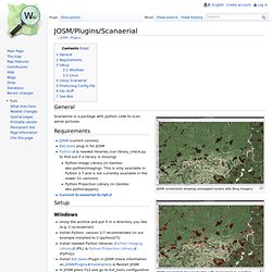
JOSM/Plugins/Scanaerial. General JOSM screenshot showing unmapped tundra with Bing Imagery JOSM screenshot showing tundra with mapped lakes and Bing Imagery JOSM screenshot showing tundra with mapped lakes, data only Scanaerial is a package with python code to scan aerial pictures.
Requirements JOSM (current version) Ext_tools plug-in for JOSM Python & needed libraries (run library_check.py to find out if a library is missing) Python Image Library (in Gentoo: dev-python/imaging). Setup Windows Unzip the archive and put it in a directory you like (e.g. C:\python27\python.exe C:\scanaerial\scanaerial.py {lat} {lon} {TZoom} or if there is a space in the name of the directory (e.g. C:\python27\python.exe "C:\scan aerial\scanaerial.py" {lat} {lon} {TZoom} It will create a new menu item in the tools menu. Linux Unzip the contents of the downloaded archive to the JOSM Plugin directory. /home/<username>/.josm/plugins/ext_tools/scanaerial/scanaerial.py {lat} {lon} {TZoom} Walking Papers. Weave (Web-based Analysis and Visualization Environment)
Vespucci OSM Editor - Google Apps sur l'Android Market. This is a 10 days Trial for MapPad PRO.
MapPad Pro is providing multi-purpose mapping solution allowing location capture and data management. With MapPad, you can capture and share your tracks and measurements with number of well known cloud providers like G-Drive, Dropbox, Google Fusion Tables or export results to the local geo files like GPX or KML. Please visit our website to find out how to get OFFLINE MAPS - and get more information about this product.MapPad is a very useful tool for anyone involved in forestry, agriculture, roofing, fencing, construction, planning or farming business.
It also can be used in the whole range of outdoor activities like golf, biking, walking, running, jogging and other sports where possibility of measure area or length can be useful for development and further analysis in e.g. Google Earth. OpenFixMap - Google Apps sur l'Android Market. OpenFixMap is an open source application that shows OpenStreetMap errors.
OpenFixMap is built to fetch errors from different places, is can for example fetch error reported by Users on OpenStreetBugs. It can also take errors from machine computed error lists as KeepRight. There are plan to support other platforms so, if your favorite plateforms isn't already supported, is may be added in a near future by me or by one of your future patch ;) OpenFixMap es una aplicación de código abierto que muestra los errores de OpenStreetMap.
v2.3.2 documentation. Imposm is an importer for OpenStreetMap data.
It reads XML and PBF files and can import the data into PostgreSQL/PostGIS databases. It is designed to create databases that are optimized for rendering/WMS services. Olhttp.djangozoom.net. Www.osm-tools.org - Page principale. Geofabrik Tools. Help Please wait...
Map Show area on: zoom=2 Data/Maps Copyright 2014 Geofabrik GmbH and OpenStreetMap Contributors | Map tiles: Creative Commons BY-SA 2.0 Data: ODbL 1.0 | Contact. ITO - OpenStreetMap Tools.