
Natural Earth. OpenStreetMap. Stats. Places to find information about OpenStreetMap's database...
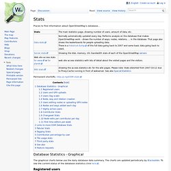
Permanent shortURL: Database Statistics - Graphical The graphical charts below use the daily database data summary. The charts are updated periodically by Blackadder. To see the current status of the database statistics click here. Registered users Users and GPX uploads Users (log scale) Node, way and relation creation On the following two graphs the statistics count was changed on 2007-08-01. Users editing nodes or uploading GPX nodes Nodes and ways added each day Highly active users Contributor Stats Changeset Stats Node edits per contributor per day First time editors per week Links to more OSM Database Stats Density Maps and Mapping Speed for a few selected countries Editor usage stats generated from changeset information since API 0.6. Tabular Stats Tagging Stats Have a look at taginfo.openstreetmap.org for up to date worldwide statistics on tag usage.
Contribution percentage by user. Potlatch – the OpenStreetMap editor. Potlatch. Potlatch 2 (sometimes referred to as P2) is an OpenStreetMap editor.
It requires a flash plugin in the browser (not a big problem for most people); therefore it does not support all browsers (no plugin available for some). Potlatch 2 was completely rewritten from the original Potlatch 1, its major new features include: User-friendly tagging with customisable presets WYSIWYG rendering Vector Background Layers A more flexible undo/redo system OAuth support so you can deploy it on other websites Places to use Potlatch 2 It is available inside the "Edit ▼" menu on the www.osm.org homepage (of course you also can select it as your standard editor in your user preferences).
Potlatch 2 is also deployed on a number of websites, some with significant customisations. How to use Potlatch 2 Basic editing Advanced editing Potlatch 2/relations: How to create relations with Potlach 2 Potlatch 2/restrictions: for restrictions at crossings Using vector background layers in Potlatch 2 Feedback and bugs. PDX API. GIS Data Catalog. PDX GIS Metadata. OpenLayers: Home. Spatial Database Tips and Tricks : Query Spatial Database from M. The Microsoft Live Maps and Google Maps projection.
I have lately seen several blogposts confused about which datum and projection Microsoft’s Live Maps (Virtual Earth) and Google Maps use.
As most people already know by now, they render the round earth onto a flat screen using a Mercator projection. I think the confusion comes from that they actually use two spatial reference systems at the same time: Geographic Longitude/Latitude coordinatesystem based on the standard WGS84 datum. Mercator projection using a datum based on WGS84, BUT modified to be spheric. So when is what used? The Javascript API’s use (1) as input when you want to add points, lines and polygons. If you want to create image overlays, or roll your own tile server on top of the map, you will need to project your images into a spheric mercator projection. Here’s a bit of facts about the two projections: The valid range of (1) is: [-180,-85.05112877980659] to [180, 85.05112877980659]. Proj.4 definition for (1):+proj=longlat +ellps=WGS84 +datum=WGS84 +no_defs.
Transform 8307 to 3785 (google maps) Oracle Maps. Map tile server configuration settings are stored in local configuration files and in database views.
You can customize these settings. 8.2.2.2 Map Tile Layer Configuration The configuration settings for a map tile layer are stored in the USER_SDO_CACHED_MAPS metadata view. You should normally not manipulate this view directly, but should instead use the MapViewer administration tool, which uses this view to configure map tile layers. Each database user (schema) has its own USER_SDO_CACHED_MAPS view. The map tile server obtains the map source configuration by querying the USER_SDO_CACHED_MAPS view using the database connections specified by MapViewer data sources. The USER_SDO_CACHED_MAPS view has the columns listed in Table 8-1. Table 8-1 USER_SDO_CACHED_MAPS View For the DEFINITION column, the map source definition has the following general format: The DTD of the map tile layer definition XML is listed in Section A.9.