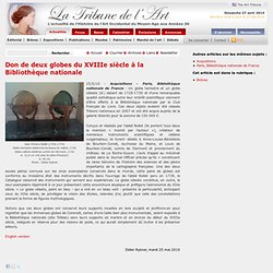

Exploring Local. Don de deux globes du XVIIIe siècle à la Bibliothèque nationale. Jean Antoine Nollet (1700-1770)Globe terrestre dédié à la duchesse du Maine, 1728Globe céleste dédié au comte de Clermont, 1730 D. 32,5 cm (46 avec la table d’horizon) H. 55 cm Photo : Didier Rykner 25/5/10 - Acquisitions - Paris, Bibliothèque nationale de France - Un globe terrestre et un globe céleste (ill.) datant de 1728-1730 et d’une remarquable qualité esthétique outre leur intérêt scientifique viennent d’être offerts à la Bibliothèque nationale par le Club Français du Livre.

Ces deux objets avaient été classés Trésors nationaux en 2007 et ont été acquis auprès de la galerie Steinitz pour la somme de 150 000 €. Des villages de Cassini aux communes d'aujourd'hui. Territoires et population, deux siècles d'évolution. Histoire de la cartographie, cultures et savoirs géographiques. Cybergeo : European Journal of Geography.
Bérénice Bon article 951, 06 août 2020 Elsa Filâtre article 950, 05 août 2020 Mikhail Rogov et Céline Rozenblat article 949, 23 juillet 2020 Amine Benzerara et Abdelhak Acidi article 948, 22 juillet 2020 Claude Bataillon (Autour des camps de regroupement de la guerre d’Algérie) 27 juin 2020 Paru dans Débats , Les lieux de la guerre d'Algérie Alain L’Hostis article 947, 24 juin 2020 Alexandra Locquet et Stéphane Héritier article 946, 11 juin 2020 Ousmane Sidibé, Henri Kouassi Kouadio, Issouf Bamba et Edouard Kouassi Konan Diachronic analysis of changes in forest cover structure derived from digital thematic maps from Landsat satellite imagery using landscape metrics article 945, 28 mai 2020 Eudes Girard 25 mai 2020 Paru dans Débats , Le grand confinement : avant, pendant, et après ?
TypeBrewer.org. The Paradise Project. Document Contents: See Also: Objective: The objective of the Paradise project is to design, implement, and evaluate a scalable, parallel geographic information system that is capable of storing and manipulating massive data sets.

By applying object-oriented and parallel database technologies to the problem of storing and manipulating geographic information we hope to significantly advance the size and complexity of GIS data sets that can be successfully stored, browsed, and queried. Client Server Paradise: Paradise is a database system aimed at handling GIS types of applications. The Paradise front end allows you to display objects with spatial attributes on a 2-D map. The database can be queried either with a graphical interface or with ad-hoc queries. Paradise supports a subset of SQL for issuing ad-hoc queries. The current version of Paradise employs a client-server architecture. Samples of the Paradise Frontend. Projects - Nathan Kerr. Connecting Location Data with Decision Engines.
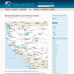
Blog. The download manager will be updated the next couple weeks.

In the meantime, please check out the ZIP, linked below, to get the 61 changed GIS shapefiles (SHP). Release notes follow. NOTE: Version 1.1.1 corrects the name of the 50m cultural “50m_admin_0_countries” file by adding the missing “r” (XQHSANQW71), updated March 15, 2010. Thanks Ben! Thanks to over 50 contributors for making version 1.1 happen!
NACIS: Welcome to NACIS.org. FREAC - Florida Resources and Environmental Analysis Center at FSU. About. Avenza Systems Inc. Simplegeo/betashapes - GitHub. Flickr Shapefiles browser. I’ve revised my Flickr Shapefiles program to allow greater user interaction. This new version allows the user to query the Flickr Shapefiles dataset using a bounding box and selection of the appropriate place type (Neighbourhood, Locality, Region, Country, Continent). I’ve also changed the base mapping. The previous version of the project used the Microsoft Hybrid base map but I’ve now replaced this with my own Cloudmade style. Using the bounding box it’s possible to browse the Shapefiles available for an area quite easily. However marking out a large area can generate a huge list of Shapefiles particularly in more populated areas.
Some example images… paris europe africa Click the image below to start the full application. Flickr Shapefiles browser (MapToPixel) Kelso’s Corner. I prompted a flurry of PostGIS hate (and some love) on Twitter last week, documented via Storify.

I’ve been using PostGIS for around 2 years now both at Stamen and before that at The Washington Post. Let me say upfront that PostGIS is amazing and is definitely in the top 5 best FOSS4G (free and open source software for geo) out there. It is a super powerful spatial data store that is free to download, install, and use (even in commercial projects!). It’s can also be mind numbingly difficult to install and use. It doesn’t matter how awesome something is unless it’s usable. Besides the specific issues outlined below, PostGIS lacks basic functions required for spatial analysis found in ArcToolbox.
@PostGIS asked me for details on how it could be friendlier and I’ve itemized around 20 below. If a project that is considered core to the FOSS4G stack (eg Mapnik, PostGIS, etc), the project needs to act like it. As of today, the latest LTS is 12.04, before that is 10.04. UWCL - Home. CartoTalk.