
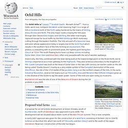
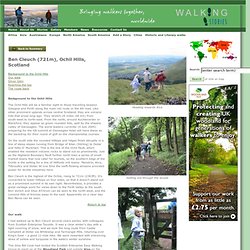
Ochil Hills. Ochil Hills (Wood Hill and Elistoun Hill) viewed from south-west of Tillicoultry The Ochil Hills ( i/ˈoʊxəl/;[1] Scottish Gaelic: Monadh Ochail[2] - from a Celtic word root, compare Old Welsh uchel meaning 'high') is a range of hills in Scotland north of the Forth valley bordered by the towns of Stirling, Alloa, Kinross and Perth.
The only major roads crossing the hills pass through Glen Devon/Glen Eagles and Glenfarg, the latter now largely replaced except for local traffic by the M90 Edinburgh-Perth motorway cutting through the eastern foothills. The hills are part of a Devonian lava extrusion whose appearance today is largely due to the Ochil Fault which results in the southern face of the hills forming an escarpment. The plateau is undulating with no prominent peak, the highest point being Ben Cleuch at 721m The south-flowing burns have cut deep ravines including Dollar Glen, Silver Glen and Alva Glen, often only passable with the aid of wooden walkways. Proposed wind farms[edit] The Ochil Hills.
The Ochil Hills are a long range of steeply sided, round topped hills, stretching 25 miles from the Firth of Tay to Stirling..
There are many peaks over 2,000 ft offering splendid views across central Scotland and to the north. Colourful hill names include Whitewisp, Steele's Knowe, Craigentaggert, The Nebit, Bengengie, and Ben Cleuch which is the highest at 2,363 ft (721 m). Visible from much of Strathearn, these rolling green hills are the backdrop for the villages of Bridge of Earn, Dunning and Auchterarder. Overview of Ochil Hills. A range of hills in Central Scotland, the Ochil Hills extend for more than 24 miles (35 km) eastwards from Dunblane and Bridge of Allan in Stirling Council Area through, Clackmannanshire, Perth and Kinross and into Fife where it tails off eastwards along the south side of the River Tay.
Largely comprising volcanic andesite from the Devonian period, the highest point in the range is Ben Cleuch which rises to 721m (2363 feet). The steep sided north-facing slopes of the range above the hillfoot towns of Menstrie, Alva, Tillicoultry and Dollar are the result of the Ochil Hills geological fault which caused the subsidence of land now forming the Clackmannanshire plain, an area comprising younger sediments including coal.
Associated with the volcanic rocks of the Ochil Hills are deposits of copper and silver which have been worked, as at Bridge of Allan and Sterling Glen. Forth Valley - North - Panorama. CLEUCH-S.gif (GIF Image, 4225 × 2412 pixels) - Scaled (26%) CLEUCH-N.gif (GIF Image, 4225 × 2410 pixels) - Scaled (26%) Hillwalking in the Ochils. Hillwalking Ochil Hills from Bridge of Allan in Stirling to Newburgh in Fife. Your pathway to the Real Scotland - WOTM Nov 12 Ochil Hills. View topic - Ochil Hills. Free to be able to rate and comment on reports (as well as access 1:25000 mapping).

In Fife for a few days so I took the chance to venture into the Ochil Hills for the first time since I started hillwalking. Kicked off in Mill Glen. Very scenic woodland walk with some impressive waterfalls due mainly to a recent deluge of heavy rain. Heard a few worrying reports about The Law. Surprisingly steep, apparently. Things had started off brightly but the forecast was for rain later in the afternoon. I had a bit of luck as the rain turned out to be only a short shower, and the wind disappeared as I dropped down the far side towards Ben Ever. Being a Scrambling fanatic, the Ochils were only supposed to be a minor distraction for me, but I actually liked them a lot. The Old Quarry. Mill Glen. And again. Last bridge before The Law.
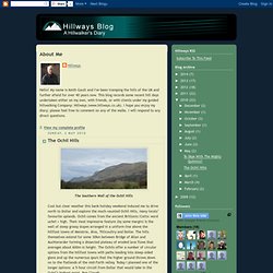
Looking back down Mill Glen. Hillways: The Ochil Hills. The Southern Wall of the Ochil Hills Cool but clear weather this bank holiday weekend induced me to drive north to Dollar and explore the much-vaunted Ochil Hills, many locals’ favourite uplands.
Ochil comes from the ancient Brittonic/Celtic word uchel = high. Their most impressive feature (by some margin) is the wall of steep grassy slopes arranged in a uniform line above the hillfoot towns of Menstrie, Alva, Tillicoultry and Dollar. Ben Cleuch (721m), Ochil Hills, Scotland. Ben Cleuch (721m), Ochil Hills, Scotland.
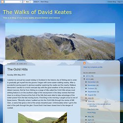
The Walks of David Keates: The Ochil Hills. Sunday 26th May 2013.
The Ochil Hills - Ben Cleuch and Bengengie Hill - Car Free Walks. Walk of the week: Ben Cleuch, Ochil Hills - News. MUNRO-BAGGERS will find themselves climbing the grandest mountains in Scotland, but if they turn their noses up at the smaller peaks, they'll miss out on some treasures.
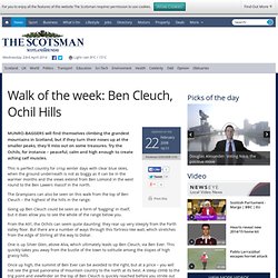
Try the Ochils, for instance – peaceful, calm and high enough to create aching calf muscles. Stirling Scotland - Walks in the Ochil Hills. By 1830, nine mills used the fast flowing water of Alva Burn to drive their machines.
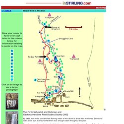
Dams and lades were built to ensure that there was enough water throughout the year. From the car park near the Longbank Works make your way into Macarthur Braes. Follow the path to the Glen, crossing the bridge and turning left to arrive at a view point for the dam. Follow the steps up to the left and go under a large, metal pipe which crosses over the path.The distance to Smugglers Cave is 1.5km, at a height of 200m. It should take around 45 minutes to get there - allow 30 minutes to return. From Smuggler's Cave, another quarter of a mile will take you to the Spout of Craighorn. Ben Cleuch Feature Page on Undiscovered Scotland. The Ochils are the hills extending from Stirling in the west to the M90 south of Perth in the east.
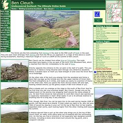
They are seen most strikingly from Stirling and from the M9 as you approach it: a ridge of hills above a south-facing escarpment, reaching a maximum height of 721m or 2364ft at the summit of Ben Cleuch. Ben Cleuch can be climbed from either Alva or Tillicoultry. King's Seat Hill Feature Page on Undiscovered Scotland. King's Seat Hill stands out in distant views of the Ochil Hills far more than its 648m height would lead you to expect. In a range of hills whose higher members hide shyly behind lower hills on the line of the escarpment, King's Seat Hill is fully visible, rising directly from the line of the A91 between Tillicoultry and Dollar. The climb of King's Seat Hill is direct and straightforward. From Dollar follow the signs to Castle Campbell. These leads you through the twists and turns of this attractive little town.
You can park in the Dollar Glen car park, on the very edge of Dollar: or you can take your chances on a very narrow single track road leading a couple of hundred yards uphill to the fairly restricted parking area for Castle Campbell. The Ochil Hills. Skip to navigation. Ochil Hills: Dollar Glen. This is a free sample walk but you need to log in as a member of Walkingworld to access the details. Join or log in above if you are already a member. The walk starts and finishes in Dollar, a small town at the southern edge of the Ochil Hills.
The route rises through the western side of Dollar Glen, a deep, tree-filled gorge with waterfalls and mossy rocks. The glen is home to the spectacular, fifteenth century Castle Campbell which can be visited for a small charge. Beyond the castle the route levels out and passes through a coniferous forest and on to open moorland. Alva Glen - (Scotland) Walking In The Ochil Hills. Clackmannanshire Tourism. Ochil Hills Woodland Park. Discover Clackmannanshire - The Ochil Hills and Glens. One of Clackmannanshire's greatest natural assets are the Ochil Hills, which stretch 20 kilometers from Blairlogie to Yetts of Muckhart. With peaks at over 2,000 feet, there are splendid views across Central Scotland and to the north from the summits. If your not interested in climbing high but like the idea of seeing some stunning scenery, a walk up any one of the Glens along established tracks and paths, will bring ample rewards.
Remember to wear suitable footwear, take extra care in wet weather, and follow the Outdoor Access Code. Alva Glen Alva Glen offers easy walking in spectacular and beautiful surroundings, and within an area of both historical and cultural significance. Much work is taking place to preserve the natural heritage of Alva Glen, the Alva Glen Heritage Trust is a volunteer organisation committed to safeguarding and improving the Glen's matural and cultural heritage.
OS Map: Explorer 366, Stirling and Ochil Hills West. Stirling & Ochil Hills West - Maps. List of hills & maps « FotO. There are 60 hills in the Ochils over 300 metres high (984 feet) with a drop all round of at least 30 metres. VisitScotland Perthshire - Auchterarder & The Ochils. Ochils Landscape Partnership. Ochils Landscape Partnership. Ochils Mountain Rescue Team. Ochil Hill Runners. The Ochils Mountaineering Club - Home. Following the success of our 2013 and 2014 calendars, we are creating next year's calendar now, so that we can promote it well before the end of the year in order to maximise sales. We therefore need 12 excellent images to represent each month. The images do not need to have been taken in any specific month, or to have been taken this year, but must be of Scotland. Any photo's taken of Scottish landscapes will be considered, but preferably, they will be mountain scenes. Ideally, we would like photographs from 12 different members so please send your images by 30th April.
But don't wait until then, the sooner we receive them the better. Please send any images you feel suitable to Graeme WallaceThis e-mail address is being protected from spam bots, you need JavaScript enabled to view it stating your name, what the photograph is of, and which month it was taken in.