
Incredibly Detailed Map Of The World's Religions. Map created by reddit user scolbert08 The incredibly detailed map of the world’s religions above, was created by reddit user scolbert08.
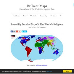
To see the full resolution version just click on it. It shows what the biggest religion is by census area in each country, along with its level of support. For example, in large parts of British Columbia the most common answer on the census is no religion, but the intensity of that feeling varies widely. Another important thing to note is that while Christianity is divided between Catholicism, Protestantism and Orthodox denominations, Islam is not similarly divided between Sunnis and Shias. Worldwide Airport Coverage Map. 40 Creative Remakes of The World Map - Hongkiat.
If you don’t have the pleasure to be a student in a geography class where the teacher can draw an entire world map from memory (plot twist: the teacher is a History teacher, according to the comments), then it’s safe to assume that geography is probably not your favorite class.
That’s fine, we’re not here to give you a geography lecture, but in this post, you will be looking at a lot of world maps. The good news is that the world maps you will be seeing are beautiful and creative remakes done by talented designers out there. Keep in mind that as far as accuracies are concerned, these designers flex their creative license muscles as much as they can, and you’ll probably admire what they have created. Read more: 10 Tools to Create Your Own Map World Map Typography. Ayuda en Acción Annual Report 2014. Kid’s Playmat. Across the Globe. Color. Watercolors. World Travel Decor. Paint Splatter. Fabric Wall Decal. Beer For All Seasons #7.
Jerrysmap. La carte du monde des sexualités. Le printemps vient de poindre le bout de son nez.
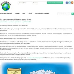
Ne nous le cachons pas, nos corps se réveillent et notre libido, elle aussi, sort de son hibernation. Chacun retrouve ses envies les plus intimes. Pour certain, ce sera l’exhibitionnisme, pour d’autres, la soumission. Enfin, d’autres, sûrement moins nombreux, auront quelques chaleurs à la vue de leur compagne déguisée en ours en peluche. Nous ne sommes pas là pour juger. Franklin Veaux a dessiné une carte imaginaire où il a compilé une quantité impressionnante de -philie. Quelques îles regroupent les sexualités limites. Cette carte n’est pas complète. Vous pouvez vous fabriquer votre propre carte sur www.humansexmap.com, à afficher au dessus de votre lit. Via. Jc fichet sur Twitter : "Jolie #cartographie d'un paysage de #maths via @ValeriePestre #strange_map...
Metro-style world map. Map-of-the-internet-10-explore-this-beautiful-handdrawn-map-of-the-online-world-9098834. Vargic began the project in December 2013, using old National Geographic maps for visual inspiration and Alexa data of the most visited websites in the world to scale the different land masses.
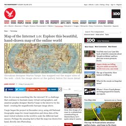
Perhaps the amazing fact is that the map was drawn free hand, directly into Photoshop. "My map is divided into two distinct parts,” Vargic explained to The Independent. “The eastern continent, the Old World, showcases software companies, gaming companies and some of the more real-life oriented websites. " "The western part, the New World, is composed from two major continents; the northern one showcasing social networks, search websites, video websites, blogs, forums and art websites. All major adult-oriented websites, in addition to various warez and torrent sites, are located on the south-western continent. " Loading gallery. A Wonderfully Stereotypical 1970s Map of New York.
How might a person who’s never left New York City view the rest of the world?
Perhaps with Manhattan taking up 80 percent of the U.S., the other four boroughs 10 percent, the Midwest completely nonexistent, and foreign countries reduced to vague presences somewhere across the water. That’s the view of this wonderful 1970s map lampooning a New Yorker’s self-centered geography. The snarky cartographer remains anonymous, according to the David Rumsey Map Collection. Here’s a wide view: Notice how the author erases most everything west of the Hudson and New Jersey until arriving at the Pacific outposts of San Francisco and L.A. Zooming in on the gigantic colony of Manhattan reveals a wealth of detail: 360° Aerial Panorama, 3D Virtual Tours Around the World, Photos of the Most Interesting Places on the Earth. Barry Lawrence Ruderman Antique Maps Inc. A sneak preview of 3D Imaging at the Osher Map Library and Smith Center for Cartographic Education. Moving forward into the future of digitizing our cultural heritage, OML’s Digital Imaging Center is engaged in an innovative project to three-dimensionally image the library’s rare globe collection, the second-largest of its kind in a U.S. public institution.
Generous grants from the National Endowment for the Humanities and the Friends of the Osher Map Library support the conservation, and subsequent 3D imaging, of the collection's most threatened or valuable items. Digitization will make it possible for students and members of the public to manipulate and examine the rare globes online, preventing potential handling damage to these delicate objects. A digital undertaking such as this is no small task, considering that full-rounded 3D imaging by cultural institutions is still at its infant stage. E-Commerce meets Cultural Heritage. Site Map of timeanddate.com. Search Site / Articles City / Country Social Share this page / Follow us on: Facebook TweetFollow Twitter Google+
Old maps of Seven Seas (Open Ocean) How does it work?

These instructions will show you how to find historical maps online. Getting started. An Illustrated Guide to Space Maps. Nebra Sky Disc, Germany, 1600 BC.
(Photo: Rainer Zenz/WikiCommons CC BY-SA 3.0) With its patinated bronze background and shiny gold sun, moon and stars, the 3600-year-old Nebra Sky Disc is worth gazing at for its beauty alone. But the ancient object is cool for a lot of other reasons: It’s the earliest depiction of outer space we’ve ever found, and it’s also thought to be the oldest known portable astronomical instrument. For as long as humans have stared at the sky, we have sought to understand our place in the cosmos.