
Lizard Point Geography Quizzes clickable map quizzes for fun and learning. Presidents. American History in Video. Library of Congress. Middle Ages Religion. Middle Ages Religion - The Christian Religion (Christianity)The Christian religion, or Christianity, is the name given to the system of religious belief and practice which was taught by Jesus Christ in the country of Palestine during the reign of the Roman Emperor Tiberius (42 BC - AD 37).
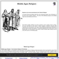
Christianity took its rise in Judaism. Jesus Christ, its founder, and His disciples were all orthodox Jews. The new Christian religion emerged based on the testimony of the Scriptures, as interpreted by the life of Jesus Christ and the teaching of His Apostles, which were documented in the Bible. Religion during the Middle Ages Middle Ages Religion - The Rise of the Christian Religion (Christianity) in the Roman EraChristianity began among a small number of Jews (about 120, see Acts 1:15).
Here’s How America Uses Its Land. Using surveys, satellite images and categorizations from various government agencies, the U.S. Department of Agriculture divides the U.S. into six major types of land. The data can’t be pinpointed to a city block—each square on the map represents 250,000 acres of land. But piecing the data together state-by-state can give a general sense of how U.S. land is used.
Download 91,000 Historic Maps from the Massive David Rumsey Map Collection. Three years ago, we highlighted one of the most comprehensive map collections in existence, the David Rumsey Map Collection, then newly moved to Stanford University.

The Rumsey Collection, we wrote then, “contains a seemingly inexhaustible supply of cartographic images”—justifiable hyperbole, considering the amount of time it would take any one person to absorb the over 150,000 physical artifacts Rumsey has amassed in one place. By 2016, Rumsey had made almost half the collection—over 67,000 images—freely available in a digital archive that has been growing since 1996. Each entry features high-resolution scans for specialists (you can download them for free) and more manageable image sizes for enthusiasts; a wealth of data about provenance and historical context; and digital, user-friendly tools that use crowd-sourcing to measure the accuracy of antiquated maps against GPS renderings. To make this document even more compelling, it contains its own bibliography. Related Content: Pearl Harbor - World War II. The Japanese plan was simple: Destroy the Pacific Fleet.
That way, the Americans would not be able to fight back as Japan’s armed forces spread across the South Pacific. On December 7, after months of planning and practice, the Japanese launched their attack. At about 8 a.m., Japanese planes filled the sky over Pearl Harbor. Bombs and bullets rained onto the vessels moored below. Female WWII Pilots: The Original Fly Girls. WASP (from left) Frances Green, Margaret Kirchner, Ann Waldner and Blanche Osborn leave their B-17, called Pistol Packin' Mama, during ferry training at Lockbourne Army Air Force base in Ohio.

They're carrying their parachutes. National Archives hide caption toggle caption National Archives In 1942, the United States was faced with a severe shortage of pilots, and leaders gambled on an experimental program to help fill the void: Train women to fly military aircraft so male pilots could be released for combat duty overseas. Smithsonian. America's History in the Making — Historical Thinking Skills Interactives. This series of interactive activities introduces and models the Historical Thinking Skills defined by the National Center for History in the Schools.
The interactives each model a specific skill or set of skills, such as analyzing historical artifacts or using primary sources to develop a thesis. The first five interactives conclude with "Classroom Extensions," which give teachers hints on how they can teach using these skills in their classrooms.
101 Web 2.0 Teaching Tools. Online tools and resources have made it easier for teachers to instruct students, and for students to collaborate with those teachers and with other students and parents.
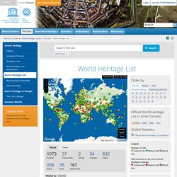
These “Web 2.0” teaching tools aren’t magical, but they may seem to defy definition at times since they save time, help you to stay organized, and often take up little space on a computer. Discovery Education - Virtual Field Trips. The map as history : a multimedia atlas of world history with animated historical maps. UNESCO World Heritage List. #: As for 19 Natural and Mixed Properties inscribed for geological values before 1994, criteria numbering of this property has changed.
See Decision 30.COM 8D.1. Decoding Symbols in Renaissance Art. By Ruchi Bhalla Renaissance art is rich not only in terms of beauty, aesthetics and technique but also in terms of the colours and symbols that it carries, portraying an insightful visual language.
There are some symbols that have held consistency in their meaning and make recurrent appearances in prominent masterpieces. The deeper you delve into the Renaissance art, the more intriguing and open to interpretation it becomes. The world of Renaissance art is the bridge between past, present and future, in order to understand it you have to become one with it, hence we will take a look at the secrets hidden to the uninitiated in them.