West Papua (region) The region is 1,200 km from east to west and 736 km from north to south.
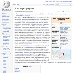
It has an area of 420,540 km2 (162,371 sq mi), which equates to approximately 22% of Indonesia's land area. The border with Papua New Guinea mostly follows the 141st meridian east, with one section defined by the Fly River.[9] The island of New Guinea was once part of the Australian landmass and lie on the Sahul. The collision between the Indo-Australian Plate and Pacific plate resulting in the Maoke Mountains run through the centre of the region and are 600 km (373 mi) long and 100 km (62 mi) across. [citation needed] The range includes about ten peaks over 4,000 metres (13,120 feet),[10] including Puncak Jaya (4,884 m), Puncak Mandala (4,760 m) and Puncak Trikora (4,750 m).[11] The range ensures a steady supply of rain from the tropical atmosphere.
The rugged and hilly topography of West Papua. The province has 40 major rivers, 12 lakes, and 40 islands. Dutch expeditions in Netherlands New Guinea 1907–1915. New Caledonia. Coordinates:
Papua New Guinea. Papua New Guinea is one of the most culturally diverse countries in the world; 848 languages are listed for the country, of which 12 have no known living speakers.[9] Most of the population of over 7 million people live in customary communities, which are as diverse as the languages.[10] It is also one of the most rural, as only 18 percent of its people live in urban centres.[11] The country is one of the world's least explored, culturally and geographically, and many undiscovered species of plants and animals are thought to exist in the interior.[12] At the local level, the majority of the population still live in strong customary societies and – while social life is overlaid with traditional religious cosmologies and modern practices, including conventional primary education – customary subsistence-based agriculture remains fundamental.[10] These societies and clans are explicitly acknowledged within the nation's constitutional framework.
Fiji. Country in the South Pacific Fiji ( FEE-jee; Fijian: Viti [ˈβitʃi]; Fiji Hindi: फ़िजी, Fijī), officially the Republic of Fiji,[13] is an island country in Melanesia, part of Oceania in the South Pacific Ocean about 1,100 nautical miles (2,000 km; 1,300 mi) northeast of New Zealand.
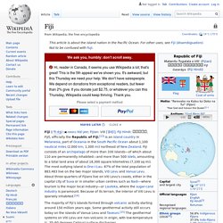
Fiji consists of an archipelago of more than 330 islands—of which about 110 are permanently inhabited—and more than 500 islets, amounting to a total land area of about 18,300 square kilometres (7,100 sq mi). The most outlying island is Ono-i-Lau. 87% of the total population of 883,483 live on the two major islands, Viti Levu and Vanua Levu. About three-quarters of Fijians live on Viti Levu's coasts, either in the capital city of Suva or in smaller urban centres such as Nadi—where tourism is the major local industry—or Lautoka, where the sugar-cane industry is paramount. Solomon Islands. The islands have been inhabited for thousands of years.
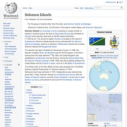
In 1568, the Spanish navigator Álvaro de Mendaña was the first European to visit them, naming them the Islas Salomón.[3] By 1893, the United Kingdom had established a protectorate over the territory. During the Second World War, the Solomon Islands campaign (1942–1945) saw fierce fighting between the United States and the Empire of Japan, such as in the Battle of Guadalcanal. The official name of the then British territory was changed from "the British Solomon Islands Protectorate" to "Solomon Islands" in 1975. Self-government was achieved in 1976. Independence was obtained two years later.
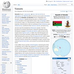
Name[edit] History[edit] Solomon Island warriors, armed with spears, aboard an ornamented war canoe (1895). It is believed that Papuan-speaking settlers began to arrive around 30,000 BC.[6] Austronesian speakers arrived c. 4000 BC also bringing cultural elements such as the outrigger canoe. Second World War[edit] Vanuatu. Country in the southwestern Pacific Vanuatu ( VAH-noo-AH-too or van-WAH-too; Bislama and French pronunciation [vanuatu]), officially the Republic of Vanuatu (French: République de Vanuatu, Bislama: Ripablik blong Vanuatu), is a Pacific island country located in the South Pacific Ocean.
LES PÊCHERIES CÔTIÈRES DE VANUATU. Mélanésie. Un article de Wikipédia, l'encyclopédie libre.
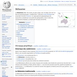
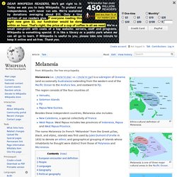
La Mélanésie (littér. îles noires, du grec μέλας 'noir' et νῆσος 'île') est l'un des trois grands groupes « traditionnels » d'îles de l'océan Pacifique qui, ensemble, forment l'Océanie. Ce regroupement géographique est aujourd'hui contesté par une partie des géographes, mais il reste très couramment employé, y compris par les pays concernés. Découpage géopolitique[modifier | modifier le code] Historique des subdivisions[modifier | modifier le code] Après l'avoir exploré à deux reprises, Jules Dumont d'Urville proposait, en 1831 à la Société de géographie (Paris), une nouvelle organisation du Pacifique en quatre parties : « Les Mélanésiens offrent une couleur de peau fort variable, dans toutes les nuances du chocolat clair. (...)
La Mélanésie traditionnelle[modifier | modifier le code] Ces États ou provinces ne constituent pas un ensemble politique homogène. De nos jours[modifier | modifier le code] En archéologie[modifier | modifier le code] S. Melanesia. Ethno-cultural definition of Melanesia.