
Blue Light Scanner, 3D Digitizer for 3D Scanning/3D Inspection/3D Measurement_Products_Shining3D_SHINING3D. OpticScan 3D Scanners | 3D Digitizer for 3D Scanning/3D Inspection/3D Measurement OpticScan 3D Scanners are the most versatile and popular 3D Scanners of Shining3D-Scanner.
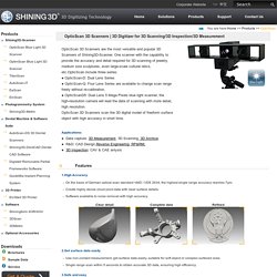
One scanner with the capability to provide the accuracy and detail required for 3D scanning of jewelry, medium size sculptures, even large-scale cultural relics, etc.OpticScan include three series: ● OpticScan-D: Dual Lens Series ● OpticScan-Q: Four Lens Series are available to change scan range freely without re-calibration. ● OpticScanD5: Dual Lens 5 Mega Pixels blue light scanner, the high-resolution camera will lead the data of scanning with more detail, high resolution. OpticScan 3D Scanners scan the 3D digital model of freeform surface object with high accuracy in short time. 1.High Accuracy Clear detail Complete data Refined 2.Get surface data easily 3.Safe and easy 4.Change scan range freely - Four lens series are available to change scan range freely without re-calibration.
2 Nikon D90 cameras, 3D portraits. Alex Fry and Jamie Nimmo will have a 3D photography exhibition "Stereo Portrait Project" in Sydney Australia on 27th May (scroll down for the full press release).

Here is the technical background: For the Stereo Portrait Project, we used off the shelf hardware and software, from the cameras, lighting, triggering, post production to the printing of the book. We shot using Nikon d90's with shutter cables connected to an RF trigger. The Lighting system was three Nikon sb900's, one connected via pc sync in a soft box, the other two optically slaved. A custom camera rig was needed to put the cameras as close together as possible, roughly emulating the distance between the human eyes. To synchronize the cameras we used an RF trigger split out to two preload shutter release cables. The image pairs were then sorted using Aperture before being exported into Nuke, where final tweaks were made before combining them into the final Anagylphic 3D images. Press Release: Turning Mobile Phones into 3D Scanners. Forge: 3D Scanning for Android. Infinite-Realities. Matterport 3D models of real interior spaces.
Open Source Photogrammetry. Photogrammetry plugin for Rhino. Autodesk 123D Catch. Photogrammetry in Archaeology. Photogrammetry is definitely the “new” thing in archaeology, slowly clawing its way into how we treat and record archaeological sites.
As far as its potentials go though, there is still a lot of research to be done, in order to assess the uses that this technology has, but also the limits that we will have to deal with on a day to day basis. One of the aspects that has always interested me is a question of scale. We’ve seen before that Photogrammetry deals well with anything ranging from an arrowhead to a small trench (4×6 is the maximum I have managed before, but there is much larger stuff out there). Smaller objects are hard to do cheaply, as the right lenses become essential, but larger stuff should be entirely possible to do with the right considerations in mind.
The results can be viewed here: As we can see, the results are of course not marvellous, but I am less interested in the results than the actual process. Apart from these problems, the results are very promising. Effiziente Auswertung von Punktwolken im CAD. Sensor Pre-Order. Home - (Fenster-Sitzung: Tools-2014-03-11) 3D Modeling Software for Urban Environments - (Fenster-Sitzung: Tools-2014-03-11) Menu Products.

Tools. Enwaii photogrammetry for VFX : Making of Smurfs 2. Plug Effects' photogrammetry masterpiece for Smurfs 2 We are delighted to present this masterpiece of photogrammetry achieved by the artists at Plug Effects.
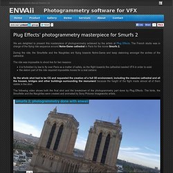
The French studio was in charge of the flying ride sequence around Notre-Dame cathedral in Paris for the movie Smurfs 2. During the ride, the Smurfette and the Naughties are flying towards Notre-Dame and keep slaloming amongst the arches of the cathedral. The ride was impossible to shoot live for two reasons: it is forbidden by law to fly over Paris as a matter of safety, so the flight towards the cathedral needed VFX in order to exist the slalom part of the ride required impossible moves for a real camera So the whole shot had to be CG and requested the creation of a full 3D environment, including the massive cathedral and all the houses, bridges and other buildings surrounding the monument because the height of the flight made almost all of them visible in the shot.
Enwaii photogrammetry for VFX. Enwashot converts raw photos from DSLR, removes distortion and generates HDR images from bracketed photos.
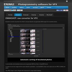
Automatic sorting of bracketed photos Select the images to convert Distortion removal and HDR generation via OpenEXR Multi directories conversion, select and forget Convert hundred of raw photos at once It automatically sorts bracketed photos and can generate HDR from them in OpenEXR format. It creates at once two images with the same distortion parameters : one OpenEXR in linear color space and one JPEG in sRGB color space.
The JPEG image is used in Maya® with Enwasculpt for image based modeling. The OpenEXR image is used for texturing in Enwamap. Enwaii photogrammetry for VFX : Making of Smurfs 2. PhotoSpace: A Vision Based Approach for Digitizing Props. Introduction. Next: 3D from images Up: Visual 3D Modeling from Previous: Contents Contents In recent years computer graphics has made tremendous progress in visualizing 3D models.
Many techniques have reached maturity and are being ported to hardware. This explains that in the area of 3D visualization performance is increasing even faster than Moore's lawA1. What required a million dollar computer a few years ago can now be achieved by a game computer costing a few hundred dollars. It is now possible to visualize complex 3D scenes in real time. Visual 3D Modeling from Images. Documents. SURE. Introduction SURE is a software solution for multi-view stereo, which enables the derivation of dense point clouds from a given set of images and its orientations.
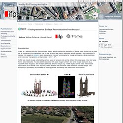
Up to one 3D point per pixel is extracted, which enables a high resolution of details. It is based on libtsgm, which implements the core functionality for image rectification, dense matching and multi-view triangulation, and provides a C/C++ API. Photogrammetrie und Computer Vision. Professur für Photogrammetrie - Image Matching / Structure from Motion (SfM) Professur für Photogrammetrie - Professur für Photogrammetrie. Software systems for image-based 3D measurement. Is now 3D Systems Geomagic! Products. Use PHOV. MeshLab.
Architectural applications « Punchcard: VideoTrace. VideoTrace allows a user to create models of object from video sequences.
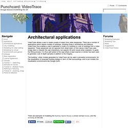
There are a number of applications which require models of buildings, including those in architecture and defence. VideoTrace thus enables a user to generate a model of a building or a set of buildings from a video sequence. These sequences can be captured from street level, or from above.VideoTrace uses image data to interpret the user interactions, but exploits 3D point clouds when available, to guide the fitting process. It is thus well suited to the case where a laser scanner or similar has been used to generate a set of depth samples in addition to the imagery. The building / urban models generated by VideoTrace can be used in simulation environments, for the visualisation of proposed building designs in term of their surroundings, and to put models into visualisation environments like Google Earth. There are examples of modelling the Sydney Opera House, a (more normal) house, and the archway on this site.
Punchcard: VideoTrace. Match Photo: Modeling from photos. Creating a 3D model to match a photo Use the matching process to create a 3D model to match one or more photos of a building or structure.
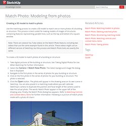
This process is best suited for making models of images of structures containing features representing parallel lines, such as the top and bottom of a square window. Note: There are several You Tube videos on the Match Photo feature, including two videos that use the same example found in this article. These videos might use an different version of SketchUp, but the process and Match Photo tools are exactly the same. Match Photo: Introduction. Match Photo introduction Use the Match New Photo and Edit Matched Photo menu items to create a 3D model to match a photo or to match an existing 3D model to a photo's context.
Activate the Match New Photo and Edit Matched Photo menu items from the Camera menu. SketchUp is commonly used to create designs of buildings or structures. SketchUp allows you to create these designs using the actual, real-world scale (a scale of 1:1 where a unit of measurement in SketchUp represents that actual unit of measurement in the real world). However, digital pictures are not at a 1:1 scale. 3DF Zephyr Evaluation Download Page - 3Dflow. Photogrammetry. Photogrammetry is an estimative scientific method that aims at recovering the exact positions and motion pathways of designated reference points located on any moving object, on its components and in the immediately adjacent environment. Photogrammetry employs high-speed imaging and the accurate methods of remote sensing in order to detect, measure and record complex 2-D and 3-D motion fields (see also SONAR, RADAR, LiDAR etc.).
Photogrammetry feeds the measurements from remote sensing and the results of imagery analysis into computational models in an attempt to successively estimate, with increasing accuracy, the actual, 3-D relative motions within the researched field. Its applications include satellite tracking of the relative positioning alterations in all Earth environments (e.g. tectonic motions etc), the research on the swimming of fish, of bird or insect flight, other relative motion processes (International Society for Photogrammetry and Remote Sensing). StereoScan. Agisoft StereoScan is an easy to use 3D modeling tool for automatic generation of textured 3D models from individual stereo pairs. The stereo pairs are not required to be calibrated or aligned, and can be captured by hand from any generic positions. Based on the close-range photogrammetry methods, StereoScan automatically calibrates the images, including camera positions and lens distortions.
Both image alignment and 3D model reconstruction is fully automated. Products. Acute3D develops breakthrough photogrammetry software solutions to automatically turn photos into photorealistic high resolution 3D models. Close-range photogrammetry and image-based modeling. Neo-Geography Toolkit - Stereo Pipeline Examples. The following HiRISE 3D surface models were built using the Stereo Pipeline. We provide them here as examples of the data products that can be generated using the software. For more information about these examples, refer to the "Data Processing Examples" Appendix in the Stereo Pipeline User's Guide.
HiRISE Columbia Hills (Crop) HiRISE observations PSP_001513_1655 and PSP_001777_1650 are on the foor of Gusev Crater and cover the area where the MER Spirit landed and has roved, including the Columbia Hills. Mementify - WebDLT. About PHOV. ARC 3D Webservice. Image Based Modeling & Photo Scanning Demos. Reality Capture For 3D Documentation. Turn photos into 3D models automatically with Smart3DCapture™ Capturing reality with automatic 3D photogrammetry software. Smart3DCapture™ applies to a variety of application areas where it dramatically enhances productivity or even opens new business opportunities. Laserscanner FARO Focus3D - Innovation und Effizienz in der 3D-Dokumentation. FARO Laser Scanner Focus3D. Photogrammetry smartphone. Mister P. MeshLab Tutorials. Open Source Photogrammetry: Ditching 123D Catch – We Did Stuff. This is part one in a series on open source photogrammetry. SynthEyes Camera Tracker - Andersson Technologies LLC.
What is SynthEyes? StereoScan. The Art of Photogrammetry: Introduction to Software and Hardware. Our brains perceive depth by comparing the images that our eyes see. If you alternatively close each of your eyes, you will notice that the object you see will seem to shift left and right. An object that is closer, will seem to shift more than an object that is farther away. That's stereoscopic vision, and the core concept behind creating the illusion of three-dimensional objects and space from two 2D images. Your brain can use this information to subconsciously calculate and tell you how far away an object is supposed to be. In a similar way, photogrammetry is a photography technique using software to map and reconstruct the shape of an object, by comparing two or more photographs.
Photogrammetry has come a long way since then, and it has even come along way since I first encountered it in my professional life years ago. The Art of Photogrammetry: Introduction to Software and Hardware. Diplomarbeiten / Masterarbeiten am ifp. Sensor Fusion. We propose an automatic procedure for combining digital images and laser scanner data in order to have a full representation of a scene. Homepage Institut für Photogrammetrie. Multi-Sensors and Multiray Reconstruction for Digital Preservation - 300fritsch.pdf. Sensors & Systems - 3D Laser Mapping Offers Innovative Visualisation Software. Details Jan 15 2014. Sensors & Systems. Using the GoPro Hero 3 for 3D Photogrammetry Modeling and Measuring.
Free photogrammetric digital reconstruction. EDIT: I forgot to put this here: the post below is a author’s guest post by Peter Falkingham of the School of Earth, Atmospheric and Environmental Science, University of Manchester. ISPRS Journal of Photogrammetry and Remote Sensing. XXII International Society for Photogrammetry & Remote Sensing Congress - Application Possibility of Smartphone as Payload for Photogrammetric UAV System. Smartphone can not only be operated under 3G network environment anytime and any place but also cost less than the existing photogrammetric UAV since it provides high-resolution image, 3D location and attitude data on a real-time basis from a variety of built-in sensors. This study is aimed to assess the feasibility of smartphone as a payload for photogrammetric UAV system. Prior to such assessment, a smartphone-based photogrammetric UAV system application was developed, through which real-time image, location and attitude data was obtained using smartphone under both static and dynamic conditions.
Subsequently the accuracy assessment on the location and attitude data obtained and sent by this system was conducted. The smartphone images were converted into ortho-images through image triangulation. The image triangulation was conducted in accordance with presence or absence of consideration of the interior orientation (IO) parameters determined by camera calibration. Asprs_2013_ron2.pdf. Photogrammetry – Creating 3D Digital Models with Smartphones. Fokus GmbH Leipzig metigo 3D. Photogrammetrie-System. Close-range photogrammetry and image-based modeling. 3D Systems Geomagic (formerly Rapidform) Products.
TECHNOLOGIES. Pixdim for Sketchup photogrammetry. Open Source Photogrammetry. Free photogrammetric software ubuntu Download - Photogrammetric software ubuntu for Windows. Systems, Inc. Cultural Heritage Imaging. Tgi3D. Automatic 3D surface fitting to photographs with Tgi3D SU PhotoScan. ARC 3D Webservice. Structure from Motion and Archaeology. ARCH 3D - Home. ARC 3D. Insight3d - opensource image based 3d modeling software. Strata3d.com. Autodesk 123D - Free 3D Modeling Software, 3D Models, DIY Projects, Personal Fabrication Tools. Tools. Match Photo: Matching models to photos. Using Photomatch in Google Sketchup.