
Royal Society. Authors *Author for correspondence (gh@arago.elte.hu).
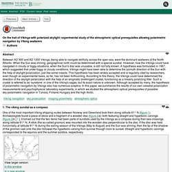
Abstract Between AD 900 and AD 1200 Vikings, being able to navigate skillfully across the open sea, were the dominant seafarers of the North Atlantic. When the Sun was shining, geographical north could be determined with a special sundial. However, how the Vikings could have navigated in cloudy or foggy situations, when the Sun's disc was unusable, is still not fully known. 17._Vikings_24_IYPT_Polska. This map of the internet is not just super-detailed, but worth framing.
Sean Cupolo's UWF Special Topics in GIS, Remote Sensing & Cartographic Skills Blog: March 2010. The displayed map was created as part of the University of West Florida Online GIS Certification program class, Cartographic Skills, (GIS 3015/L) for the Week 9 lab exercise: Flow Maps.
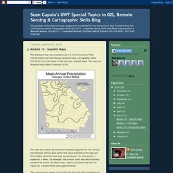
The map was generated using ESRI ArcGIS - ArcMap and then exported to Adobe Illustrator (CS4) for editing and thematic elements. How to describe the Flow Mapping experience ... to paraphrase from the words of Sheldon Cooper from the TV show, The Big Bang Theory, whilst he was paraphrasing Khan from the movie, Star Trek II: The Wrath of Khan, in reference to the actor Will Wheaton .... it tasked me.
I started this map on Tuesday and am finishing it on Sunday, I did not work on it every day but spent a considerable amount of time trying to deal with the particulars of showing the flows in the way I wanted to present them. Les cartes marines.