Understanding Earth - Frank Press, Raymond Siever, John Grotzinger, Thomas H. Jordan - Google Books. EARTH SCIENCE REGENTS REVIEW - TOPICS 13 & 14 ANSWERS. Correct answers are bold, incorrect answers are gray. 1.
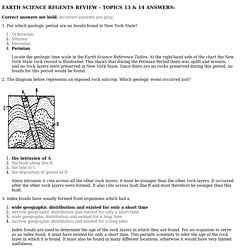
For which geologic period are no fossils found in New York State? Ordovician Silurian Devonian Permian Locate the geologic time scale in the Earth Science Reference Tables. At the right-hand side of the chart the New York State rock record is illustrated. 2. The intrusion of A the fault along line B the fold at C the deposition of gravel at D Since intrusion A cuts across all the other rock layers, it must be younger than the other rock layers. 3.
Wide geographic distribution and existed for only a short time narrow geographic distribution and existed for only a short time wide geographic distribution and existed for a long time narrow geographic distribution and existed for a long time Index fossils are used to determine the age of the rock layers in which they are found. 4. Carbon-14 potassium-40 uranium-238 rubidium-87. 2.NWplateRollover. Site Examples « Herefordshire & Worcestershire Earth Heritage Trust. Exposed Units: Much Wenlock Limestone Formation, Coalbrookdale Formation Conservation Status: Local Geological Site Whitman’s Hill Quarry is located within a complex of faulted Silurian rocks just north of the Malvern Hills.
There are two rock formations present in the quarry: 12m of the Coalbrookdale Formation which forms the basal units, and 25m of the Much Wenlock Limestone Formation which sits above. The boundary between the two units represents a rapid decrease in sea levels in the area The Coalbrookdale is characterised by olive grey to dark blue-grey silty mudstones with some calcareous siltstones and contain calcareous nodules and impersistent nodular calcareous beds. The overlying Much Wenlock Formation is characterised by pale grey nodular to thinly bedded limestones. Within these two formations nine bentonite layers can be identified. The nodular Much Wenlock Limestone (425 million years) was primarily quarried for aggregates and for the use in Lime Kilns.
Terminology. GeoGuessr - Let's explore the world! Lps. Milankovitch Tutorial. Encyclopedia of Puget Sound. Pictures, Photos of Geology and Earth Science. Geology and Earth Science Images Below are 15 different categories of Earth Science, each linked to its own gallery of an additional 10-20 or so photographs that are available for free download.
Below those categories are some additional links to photos of the Death Valley region and the San Andreas fault zone. Click on any photo below to view images in that category or click here to search geology photos by keyword. Other Images Click here for Geology of Death Valley National Park Photos. Click here for photos of the Amargosa Valley, California. Click here for photos of the San Andreas fault system. Click here for aerial photos of the Basin and Range Province, California to Utah. Click here for Structural Geology Images and diagrams Click here for Geologic Contacts. Planetary Science. Visualizations. Exploring Earth Visualizations. Videos > Catalog / Earth Science. Visual Dictionary Online > EARTH. Various sciences that study the Earth, either as a physical entity, or as a living environment for plants, animals and human beings.
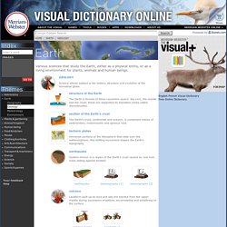
Science whose subject is the history, structure and evolution of the terrestrial globe. The Earth is formed of three concentric layers: the core, the mantle and the crust; these are separated by transition zones called discontinuities. The Earth’s crust, continental and oceanic, is composed mainly of sedimentary, metamorphic and igneous rock. Immense portions of the lithosphere that slide over the asthenosphere; this shifting movement shapes the Earth’s topography.
Sudden tremor in a region of the Earth’s crust caused by one rock mass sliding against another. Landform built up as lava and ash are ejected from the upper mantle during successive eruptions, accumulating and solidifying on the surface. Elevated landform characterized by steep slopes; it is usually part of a chain. Body of water varying in size and completely surrounded by land. Earth's Dynamic Systems. Resources For Earth Sciences and Geography Instruction - Central Michigan University. Flash simulatie, Animatie, Illustratie, Afbeelding, Grafief, Tekening, Beweging, Plot. SCIENCE - FREE Presentations in PowerPoint format, Free Interactives & Games for Kids. DOGAMI Interactive Maps. Lithographic Composition of North America.