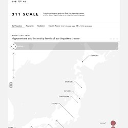

311 SCALE. We would like to offer our deepest sympathies to all of those affected by the Great East Japan Earthquake.

Although the destruction of entire towns over an area stretching for 500 kilometers to the north and south is of an almost unimaginable scale, we believe that this immense devastation can be overcome and we hope that during the process of rebuilding the disaster-affected region, we can also discover a path for the future of Japan and the world. The earthquake has also brought the new crisis of radioactive contamination to Japan. Not only is there the physical issue of the cleanup following the nuclear accident, but one of the first steps on the path to recovery must be to reduce the negative image which people have of Japan as a country contaminated by nuclear radiation, and thereby lessen the damage to Japanese industry, by presenting the world with an objective look at the current situation – at least within a range that is reasonable to modern science.
Safecast. Mohamed Nanabhay and Joi Ito at Center for Civic Media. Yes, it’s sad that I’m blogging a talk three days late.

But these were really good presentations, and I wanted to get a record of what Joi and Mohamed both said. From Friday, at the Knight-MIT Civic Media conference, a morning panel on civic media, citizen science and international news. Mohamed Nanabhay is the online editor of Al Jazeera English . He’s responsible for Al Jazeera’s English language website, which has risen to prominence during the Arab Spring. Mohamed tells us that he was the “scrappy new media guy”, a barbarian at the gates asking the company to take social media seriously. The protests in Tunisia were documented, Mohamed tells us, thanks to social media. Documenting protests became so widespread, it became less dangerous, Mohamed argues.
Mohamed suggests that we’re moving from protest as spectacle to protest as spectacular. People organizing demonstrations in Tunisia and Egypt become increasingly smart about how they used the media and how they organized themselves. Citizen science, civic media and radiation data hint at what's to come. Natural disasters and wars bring people together in unanticipated ways, as they use the tools and technologies easily at hand to help.

From crisis response to situational awareness, free or low cost online tools are empowering citizens to do more than donate money or blood: now they can donate, time, expertise or, increasingly, act as sensors. In the United States, we saw a leading edge of this phenomenon in the Gulf of Mexico, where open source oil spill reporting provided a prototype for data collection via smartphone. In Japan, an analogous effort has grown and matured in the wake of the nuclear disaster that resulted from a massive earthquake and subsequent tsunami this spring. The story of the RDTN project, which has grown into Safecast, a crowdsourced radiation detection network, isn’t new, exactly, but it’s important. Radiation monitoring and grassroots mapping in Japan has been going on since April, as Emily Gertz reported at OneEarth.org. Related: Ushahidi. Uchaguzi. Libya Crisis Map. From Crisis to Community: Mapping as a Peacebuilding Tool.
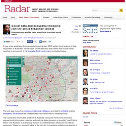
Social data and geospatial mapping join the crisis response toolset. A new online application from geospatial mapping giant ESRI applies trend analysis to help responders to Australia’s recent floods create relevance and context from social media reporting.

A screenshot of the Australian flood trends map is embedded below: This web app shows how crowdsourced social intelligence provided by Ushahidi enables emergency social data to be integrated into crisis response in a meaningful way. The combination of Ushahidi and ESRI in Australia shows that “formal and innovative approaches to information collection and analysis during disasters is possible,” said Patrick Meier, “and that there is an interface that can be crafted between official and non-official responses.” Meier is a research fellow at the Harvard Humanitarian Initiative and director of crisis mapping at Ushahidi and was reached via email. The Australian flooding web app includes the ability to toggle layers from OpenStreetMap, satellite imagery, topography, and filter by time or report type. If all you have is a Hammer, How Useful is Humanitarian Crowdsourcing? Ushahidi.pdf (application/pdf-Objekt)
Bettermap.org.