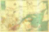
La revue Mappemonde. Cartes gratuites, fonds de carte gratuits, cartes muettes à télécharger - InterCarto. Thousands of Historic Maps Released by New York Public Library. Map of the city and county of New York, showing routes and stations of the elevated railroads.
From 1886The New York Public Library has released over 20,000 maps and cartographic works into the public domain under a Creative Commons licence. The documents, most of them hi-res, are hosted by the NYPL's Lionel Pincus & Princess Firyal Map Division, and are available for download via the Library's Map Warper, an ambitious online tool that aims to match historic maps to modern day plans. Below are a few more maps. All images are from The Lionel Pincus & Princess Firyal Map Division, The New York Public Library. Canada: Cartes géographiques gratuites, cartes géographiques muettes gratuites, cartes vierges gratuites, fonds de cartes gratuits.
Le Monde diplomatique. Worldmapper: The world as you've never seen it before. Les publications - Les collections numériques - William E. Logan et la Commission géologique du Canada : Pierre à pierre. Library Map Collection - UT Library Online. Maps Online. Some online maps are easier to navigate and manipulate than others, due in part to the large size of image-rich documents.
Several sites require special software or plugins (available for free download) to read and manipulate maps; some maps download very slowly, even with a fast connection. A large number of maps, however, are available online, covering a broad range of topics, time periods, and perspectives. This list was created to provide an introduction to the kinds of maps available online and to emphasize some of the larger collections. Le Directeur général des élections du Québec (DGEQ) - Cartothèque.