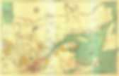
Créer une carte avec ses élèves. Courant Avril, trois classes de 4e du collège Mozart sont parties à la découverte de Belfort au XIXe siècle.
Nous avions répertorié onze sites pouvant expliquer et illustrer les transformations architecturales de cette ville avec les bouleversements industriels et politiques du XIXe siècle. Les élèves devaient prendre en photos ces 11 sites, schématiser certains d’entre eux, se repérer sur une carte pour d’autres et enfin noter quelques informations pour tous. Après cette visite, nous avons fait réaliser des panneaux explicatifs de cette visite par une des classes et l’idée de créer une carte en introduction de ces panneaux a émergé. Les élèves avaient besoin de se rappeler la localisation des lieux. Rémi Pace, étudiant en géographie, a développé un logiciel de cartographie et vantait sa simplicité de prise en main pour créer sa propre carte ou son croquis.
J’ai donc demandé à deux élèves (pendant que les autres réalisaient les panneaux) de travailler sur Abc-Map. Tutoriel : Créer une carte de qualité simplement avec Abc-Map. Changesets. Google-earth. Abc-Map - Tutoriels. Dans cette section vous trouverez des tutoriels vidéos et statiques expliquant le fonctionnement d'Abc-Map.
Vous avez un problème technique ? Vous souhaitez plus de renseignements sur ce logiciel ? Pensez à consulter la section des questions fréquentes. Tutoriels vidéo Tutoriel sur la création de croquis Disponible en ligne et en téléchargement aux formats Flash et PDF Retouvez sur le site de la communauté d'enseignants Clionautes.org un tutoriel de 30 minutes sur les principaux outils d'Abc-Map. WikiHow sur la création d'une carte simple Disponible en ligne au format HTML Retrouvez sur le site WikiHow un tutoriel étape par étape sur la création d'un itinéraire. Wiki sur RandonnerLeger.org Même sujet, la création d'un itinéraire, mais avec l'énorme plus de RandonnerLeger: un très bon forum avec des conseils de marcheurs expérimentés et des récits de voyages.
Manuel de l'utilisateur Disponible au format PDF. Q3cartes trans. Richard Edes Harrison Reinvented Mapmaking for World War 2 Americans. More Americans came into contact with maps during World War II than in any previous moment in American history.
From the elaborate and innovative inserts in the National Geographic to the schematic and tactical pictures in newspapers, maps were everywhere. On September 1, 1939, the Nazis invaded Poland, and by the end of the day a map of Europe could not be bought anywhere in the United States. In fact, Rand McNally reported selling more maps and atlases of the European theaters in the first two weeks of September than in all the years since the armistice of 1918. Two years later, the attack on Pearl Harbor again sparked a demand for maps. Two of the largest commercial mapmakers reported their largest sales to date in 1941, and by early 1942 Newsweek had named Washington, D.C. War has perennially driven interest in geography, but World War II was different. The most important innovator to step into this breach was actually not a cartographer at all, but an artist.
MapMaker Interactive. Welcome to the MapMaker Interactive This tutorial explains how to explore National Geographic Education's interactive GIS mapping tool and tools for customizing outline maps for print.

Use the zoom bar to go from a world view to a local view (or in cartographic terms, from a large scale to a small scale). U.Va. Scholars Receive Federal Grant To Develop Tool for Collecting Maps Online. Humanities scholars interested in maps and what they say about how their creators viewed the world will soon have a new digital tool at their disposal, courtesy of two University of Virginia scholars.
S. Max Edelson, an associate history professor in the College of Arts & Sciences, and Bill Ferster, a senior scientist at the Curry School of Education, recently received a $297,116 federal grant to develop a program they call "MapScholar. " MapScholar will be Web-based software that allows scholars a standardized way to combine high-resolution images of maps into online collections.
This will be a useful tool for scholars working with large sets of maps, which are often challenging to display in books or academic journals, Ferster said. A Treasure Trove of Old Maps at Your Fingertips. Atelier de Cartographie. Cartographie, cartes vectorielles, fonds de cartes - InterCarto. Réseau de recherche et de connaissances relatives aux peuples autochtones. Géo-Stat: Cartographie web et diffusion de données.
Cartographie. World Maps - Europe, Asia, America, Africa, Oceania. Humpback whale off Hermanus in the Western Cape, South Africa.
La terre vue du ciel sur lieu-geographique.com repères google earth. ATLAS HISTORIQUE - Cartographie & histoire. Histoire à la carte : un atlas historique multimédia constitué de cartes animées pour mieux comprendre l'Histoire. Fonds de cartes gratuits. Le Canada à l'échelle : les cartes de notre histoire - Expositions - Bibliothèque et Archives Canada. - Bibliothèque et Archives Canada.