
Privacy Policy. Is committed to safeguarding your privacy.
Contact us at info@didatticarte.it if you have any questions or problems regarding the use of your Personal Data and we will gladly assist you. By using this site or/and our services, you consent to the Processing of your Personal Data as described in this Privacy Policy. Table of Contents Definitions Personal Data – any information relating to an identified or identifiable natural person.Processing – any operation or set of operations which is performed on Personal Data or on sets of Personal Data.Data subject – a natural person whose Personal Data is being Processed.Child – a natural person under 16 years of age.We/us (either capitalized or not) – Google Maps & Earth news, tools, mashup, file kml e tutorial. Come usare Google Tour Builder in classe. Google Tour Builder. Google Tour Builder allows users to tell stories using Google maps, images, videos, and text.
It is a fantastic tool for students to use to show what they know about different topics. Maybe students are summarizing the chapters of a book and each placemark represents a different chapter. Or perhaps students create a tour to share summaries of current events happening around the world. There are many different ways to incorporate Google Tour Builder into the classroom. In this video, I will walk you through how to get started and show you some of the basic features of this tool. Click here to read a recent post on Google Tour Builder. In order to share your tour, click the Done Editing button. How to Use Google's My Maps in Your Classroom. This morning at the NCTIES 2016 conference I facilitated a short workshop on using Google Maps and Google Earth in the classroom.
Both tools are so robust that it is hard to cover everything you can or could do with them in just 90 minutes. To support the workshop I have a bunch of additional resources available on this Practical Ed Tech page. One of things that I introduced in the workshop was the idea of having students collaborate and create multiple layers on a map. Directions for doing that included in the slides embedded below.
Come usare Google My Maps a scuola. Un percorso sulla didattica per competenze articolato in 6 passi per comprendere cosa sia, come possa essere implementata nella didattica e documentarsi sui temi e problemi che l'approccio per competenze chiama in causa.
Ho scelto contributi di autori che per autorevolezza, chiarezza espositiva, ricchezza e completezza delle informazioni, potessero fornire un itinerario introduttivo al tema. Non sempre concordo con tutto quello che viene sostenuto in questi interventi intorno alle competenze, ma penso anche che tutti offrono spunti interessanti e stimolanti. Le risorse sono quelle che io conosco, sono certo che esistano altri contributi interessanti e utili e quando ne verrò a conoscenza li segnalerò.
Tutte le risorse sono liberamente fruibili e/o scaricabili. Il problema: cosa sono queste competenze? Le definizioni di competenza che vengono generalmente fornite risultano spesso insoddisfacenti perché: non si comprende il carattere specifico della competenza, che: Social Studies Methods and Technology: How to Make Geography Meaningful and Interesting with Google My Maps. Geography Education Geography is one of the key components of social studies education, yet it is an often overlooked aspect of many a teacher's curriculum.
I myself am guilty of cramming the Five Themes of Geography into a very hectic one or two class periods. For too long, geography has been an afterthought of the social studies, but who can really blame us? How could learning about human-environment interaction compare with the suspense of the Revolutionary War? Social Studies Methods and Technology: How to Make Geography Meaningful and Interesting with Google My Maps. Tutorial Percorso animato su una cartina geografica. Google MyMaps - Creazione mappe. Creare mappe e itinerari con Google Map Excel e il VBA. Come usare Google My Maps? Quanto lo usate? How to Create a Biking or Walking Route Map in Google Maps. How to Create Custom Maps on My Maps (Formerly Google Maps Engine Lite) Create: a map - Fusion Tables Help.
Use Fusion Tables' new look with this tutorial This 2-3 minute tutorial steps you through uploading data to generate a map with placemarks in the new version of Fusion Tables.
For this tutorial, a sample dataset is provided containing records of insects collected in Costa Rica by ecologists. Each location is recorded with a latitude and longitude point. Import the sample dataset Download this sample insect dataset. Map the data Fusion Tables auto-detects location data in a table and displays a tab called "Map of <location column name>. " Click "Map of latitude. " That's it! Customize the info window template [Optional] The default info window template automatically uses the first ten columns for this table, but you can customize which data appears and how it is displayed: Click on the Map tab and choose "Tools > Change map", then click the "Change info window" button.
You've uploaded a data file, mapped it, and customized the way each placemark's information is displayed. Google Maps polylines code generator. Create & share customized data maps on Googlemaps. Free Online Mapping tool. How to Embed Google Maps. Find the Postal Address of any Location on Google Maps. With Google Maps Lookup, you can quickly determine the approximate postal address of any location on the world map.
To get started, drag the red marker anywhere on the Google Map and the address details (including the latitude and longitude) of that place will display in the pop-up window. Embed Google Maps - Supports Street View and New Google Maps. Maps. Video - How to Create Placemarks and Layers On Google Maps Engine Lite. Earth Outreach. Prerequisites Absolutely no programming skills needed!
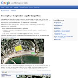
To create a map using Custom Maps, you need to be signed into your Google Account. If you don't have an account yet, you can sign up here. (It's free.) If you'd like to view your map in Google Earth, download the latest version here (it's also free). Let's get started! 1. 2. 3. 4. 5. 6. 7. 8. Now let's add data! Adding placemarks: Let's mark locations for group meeting points!
1. 11 Good Web Tools to Create Educational Maps with Students. February 10, 2014 Below is a list of some useful web tools for map creation that I have been working on over the weekend.
Think of these tools as powerful alternatives to Google Maps or Google Earth. The common denominator among all of these applications besides being simple and easy to use is that they are all web based and so do not require any software download. 1- Mapfaire Mapfaire is a web tool that allows you to create a wide variety of maps. You can add locations to your map and label them with placemarks. 2- UMapper UMapper makes it easy to create, manage, distribute and monetize online maps.With UMapper you can create interactive maps and geogames, distribute across multiple destinations, and track detailed usage. 3- Animaps.