
GPX Viewer with Drive. Mobile Walking, Running, Cycle Route Planner - plotaroute.com. Map Bike Rides with Elevation Profiles, Analyze Cycling Performance, Train Better. Ride With GPS. ANÁLISIS: ¿Cómo medir realmente la dureza de un puerto? Climbbybike.com - all cycling cols, tours and cyclo's to climb by bike worldwide. Rutas en bicicleta con GPS - Cicloide. IBP INDEX - IBP INDEX. Openrunner - Plan routes for multi-activities (hiking, running, cycling, horse riding etc) - Display the elevation profile - calculate distance and cumulated height - Export and Import GPS Tracks. Bike Route Toaster - Welcome to BikeRouteToaster.com. - APM - Altimetrías. Ruta Donosti-Hernani-Goizueta-Leitza-Berastegi-Tolosa - Aldapeta, País Vasco. Col d’Aubisque via Col de Spandelles and Col du Soulor (north)
For an overview map and details on every route I have cycled in the Pyrenées see here.
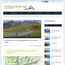
Here is an alternate, quieter route to Col d’Aubisque from Argelès-Gazost. Most cyclists take the D918 direct main road. But frankly the first 10+ kilometres to Col du Soulor just aren’t interesting and can have a fair bit of traffic in summer. For another excellent (and easier) alternate route to Aubisque via Col des Bordères – see here. Leave Argelès on the D918 following signs to Aubisque and after a kilometre or so you will see a small sign to turn right to Col de Spandelles. A few kms later there is another not-that-clearly-signed left turn …. then you can’t get lost. It’s a tiny road to Spandelles, and tightly treed so few views, but it’s a good choice for the following reasons: It’s very, very, quiet.It’s almostly completely shaded, good in a heat-wave.The descent on the other side is superb.It leads to best side of Col du Soulor.
The other side is a different world. Garmin Edge 810 In-Depth Review. The Garmin Edge 810 is a cycling GPS with built in mapping navigation that aims to build upon the previous edition of the unit, the Edge 800.
I’ve been testing the unit for a while now, and have a pretty good grasp on how well it works and how the new features and functionality pan out. Is this $499 unit worth the cash though? And are the new features enough to make you want to upgrade? The answer might surprise you. Because I want to be transparent about my reviews – Garmin sent me a final production Edge 810 unit to test out, though, it’s been running beta and release candidate firmware. Lastly, at the end of the day keep in mind I’m just like any other regular athlete out there. So – with that intro, let’s get into things. Unboxing/Components: How to download free maps to your Garmin Edge 705/800/810/1000 & Touring. The Garmin Edge series of cycling computers is roughly split into two categories: Those that have a mapping function, and those that don’t.
Mapping in this case means that the units also have routable navigation – just like your car GPS does. Whereas the cycling GPS units without mapping may be able to follow a breadcrumb trail, but can’t route you on actual streets or provide visual maps. They’re more like an Etch-a-Sketch than a phone with useful maps. The challenge though with the higher end mapping units (Garmin Edge 705/Edge 800/Edge 810/Edge 1000) is that as expensive as they are, they don’t actually include any maps. Well, ok, I’ll be fair. So instead you need to purchase more detailed maps, typically at a cost of $70-$110 per region/area. Now there’s always been a free mapping option, but it hasn’t been until semi-recently that the process of getting these maps has been made really easy. Requirements: The step-by-step pieces only take a few minutes. Part I: Downloading the maps. Spandelles-Soulor-Aubisque in ArgelÈS-Gazost, France.
Climbbybike.com - all cycling cols, tours and cyclo's to climb by bike worldwide.