
Dams Inspections. InspectionSystems. Tsioukas' blog. Clink on the image below to preview the undistortion.
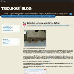
A new software for the Calibration of large format (full frame) cameras but also for wide angle lens cameras has been developed during my research activities in IUAV at the laboratory of Photogrammetry. The software is using a printed page calibration sheet and the user has to select the surrounding region of a rectangular area of circle reference points” grid to perform the calibration (see the image of the calibration grid below). After the calibration is performed the user can load any image captured from the same camera and the same settings to do the undisortion. Additionally the software can use videos to capture initially the calibration sheet and perform the calibration and since the calibration parameters have been calculated any video captured by the calibrated sensor can be undistorted. DigiCad 3D - photogrammetry, mapping, architectural surveys. Transparent images Resulting images can be transparent or opaque.
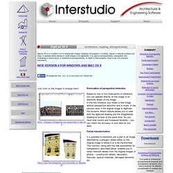
A transparent image can be superimposed on drawings or other images and is totally see-through. For example, you could superimpose a particular construction detail over a technical drawing or one map over another. An opaque image obviously covers whatever is beneath it. Mosaics Mosaic work is easy with DigiCad 3D. Two-points transformation.
ShaftMapping. FieldTesting Horse. RemoteMonitoring. GPS Accuracy. Baseline and PPM Survey receivers include static and RTK specifications.
The datasheet for the PM3 Survey Static mode looks like this: So what is up with the “1 ppm” (1 part-per-million) and "2 pm" on the Horizontal and Vertical specs? Baseline is the distance from the rover to the reference station. If you set your reference base up on the southeast corner of a section and occupy the northwest corner with your rover the baseline is 1.4 miles or 2,250 meters.
Assuming that our static occupation is long enough to fix (typically 5-15 minutes) and meets the conditions of footnote 3 (5 or more SV’s, SBAS, reasonable multi-path) we would expect our measurement to have an rms (that is root-mean-square 1-sigma) accuracy of: 0.005 meters + 1E-6 * 2,250 = 0.00725 meters (7.2 millimeters) 1 part-per-million of baseline is pretty standard for most GPS receivers so just remember:
Nikon AW120 GPS Camera. McMurdo Fastfind 220 PLB with GPS. Satellite phone and EPIRBhire. Ballon Mapping. Surveying Without Boundaries- Trimble R10 GNSS Enhancements and the New Trimble V10. Business Center. A Powerful Survey Data Office Software Suite As the desktop component of Trimble's suite of survey solutions, Trimble Business Center provides you with the capability to efficiently edit, process, and adjust your survey data with confidence.

Supported Workflows Trimble Business Center supports a wide range of workflows including: Control Surveying: Confidently produce reliable control coordinates for the span of the entire project. Field to Finish: Easily create CAD-ready deliverables directly from survey data. Trimble Business Center Photogrammetry Module An optional Photogrammetry module provides additional funcitionality to Trimble Business Center.
Survey Equipment For Sale - Pentaland Surveying. A Method Store for Advanced Survey and Modeling Technologies. Published Resources 1) Abramov, Alexey et al. “Depth-supported Real-time Video Segmentation with the Kinect.” Proceedings of the 2012 IEEE Workshop on the Applications of Computer Vision. Washington, DC, USA: IEEE Computer Society, 2012. 457–464. Web. 6 July 2012. 2) Bleiweiss, Amit et al. 3) Borenstein, Greg. 4) Boulos, Maged N Kamel et al. 5) Burba, Nathan et al. 6) Center for History and New Media. 7) Clark, Adrian, and Thammathip Piumsomboon. 8 ) Cui, Yan, and Didier Stricker. “3D Shape Scanning with a Kinect.” 9) Davison, Andrew. 10) Devereux, D. et al. 11) Dippon, Andreas, and Gudrun Klinker. 12) Droeschel, David, and Sven Behnke. “3D Body Pose Estimation Using an Adaptive Person Model for Articulated ICP.”
Imajing, mobile surveying and mapping solution.
Total Station And Its Applications In Surveying. Total Station And Its Applications In Surveying 1.
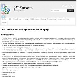
Introduction The Total station is designed for measuring of slant distances, horizontal and vertical angles and elevations in topographic and geodetic works, tachometric surveys, as well as for solution of application geodetic tasks. The measurement results can be recorded into the internal memory and transferred to a personal computer interface.The basic properties are unsurpassed range, speed and accuracy of measurements.
Total stations are developed in view of the maximal convenience of work of the user. I) Distance measuring instrument (EDM). ii) An angle measuring instrument (Theodolite). iii) A simple microprocessor. 1.2. It consists of an EDM, Theodolite, Microprocessor combined into one. Figure 1: Different Parts of Total Station.