
Geospatial Data - Mapping. The Executive Order is the latest in a series of actions - started in 2009 - in support of increasing access to and transparency of government information.
Future-Directions-in-Spatial-Demography-Report. ActiveNick's #Geospatial Dev News. Location-enabled Society: Mapping tweets using real-time big data technology and privacy. In a very appropriately titled session Taking Society's Pulse in Real-time at the Creating the Policy and Legal Framework for a Location-enabled Society conference in Boston, one item really got people's attention focussed on the issues that arise from combining location with personal data.
TweetMap is a technology that visualizes a large number of tweets on a map of the world. This is not the first time I have seen tweets mapped. But what really got people's attention is that a speaker showed how to drill down to your neighbourhood and see what the people next door are tweeting about. Of course you can do this without a map by simply following your neighbors on Twitter. But somehow mapping it makes it seem more intrusive, even invasive to some people. To be tracked geospatially on Twitter requires that you explicitly agree to geolocation tr acking for Twitter on your iPhone or Android device. MaaS (Model as a Service) is the emerging solution to design, map, integrate and publish Open Data – Cloud Computing Best Practices. Unity SpatialNews. Navigating Through the Nebulous Arena of "The Cloud" Summary: After some years of hype about cloud computing in general, the geospatial technology sector is seeing the emergence of a variety of interesting cloud-based geospatial products and services.

Andes Consulting principal, Ignacio Guerrero, reviews the landscape of “the geospatial cloud” to provide a sense of the current state of the art. The title of this article was borrowed from a recent posting in Directions Magazine on Key Resources on Geospatial Cloud Computing. Federal Programs Promo 2013. Photo: The image of a GIS Analyst - #geospatial. The Google Maps of the Internet. The Internet Map is a Google Map of the 350,000 largest websites in the world.
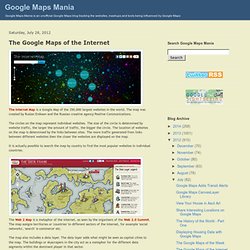
The map was created by Ruslan Enikeev and the Russian creative agency Positive Communications. The circles on the map represent individual websites. The size of the circle is determined by website traffic, the larger the amount of traffic, the bigger the circle. The location of websites on the map is determined by the links between sites. The more traffic generated from links between different websites then the closer the websites are displayed on the map. It is actually possible to search the map by country to find the most popular websites in individual countries. Socio-cultural information is critical: US Army. Your Big Data is Big Enough - Information Management Blogs Article. I have been hearing from a few people who now think the term “big data” caught on a little too fast.

Educating Future Geospatial Analysts. Louisville, home of the Kentucky Derby, great food, and this year's 2014 ASPRS annual conference.
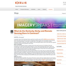
Held at the Galt House hotel, this year's conference offered a great mix of all things remote sensing over a three-day agenda. It was also co-located with a Joint Agency for Commercial Imagery Evaluation(JACIE) conference, which created a nice atmosphere where some of the best and brightest minds from science and academia could meet. Eyes in the Skies One of the most apparent trends I noticed at this show was the amount of exhibitors that had something to do with Unmanned Aerial Systems,or UAS.
With the pending approval for UAS to fly commercially, many folks are beginning to offer services surrounding these sensors. Human Geography: An Evolving Discipline. Build Dynamic Mapping Applications with ArcGIS Runtime. Sunfoundation: Heat Map Visualizes Your Daily. Wind Map. An invisible, ancient source of energy surrounds us—energy that powered the first explorations of the world, and that may be a key to the future.

This map shows you the delicate tracery of wind flowing over the US. The wind map is a personal art project, not associated with any company. We've done our best to make this as accurate as possible, but can't make any guarantees about the correctness of the data or our software. Please do not use the map or its data to fly a plane, sail a boat, or fight wildfires :-) Ten Things to Know about the Geospatial Technology Competency Model. SpatialDash. MineRP SpatialDash is all about making better and quicker business decisions by visually relating and analysing mining technical information from a variety of disciplines.
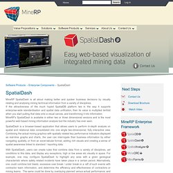
If the attractiveness of the much hyped SpatialDB platform lies in the way it supports enterprise-wide standardisation and spatial data unification, then its value is multiplied tenfold when you start putting that data onto a visual canvas, and transforming it into information. MineRP’s SpatialDash is available in either two or three dimensional versions and is the most powerful web-based mining information analysis tool the industry has ever seen.
SpatialDash is a browser-based application that allows users to perform in-depth analysis on spatial and relational data consolidated into one single two-dimensional, fully interactive view. GIS Technology Offers New Predictive Analysis to Business. Why every location tag on Facebook is big data in action. 'Eye in the Sky': the case file on NGA Director Letitia Long. By Suzanne Kelly and Pam Benson Editor's note: In the Security Clearance "Case File" series, CNN national security producers profile the key members of the intelligence community.
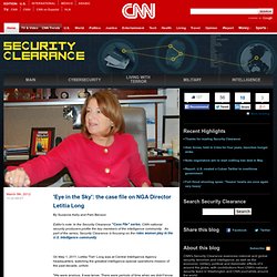
As part of the series, Security Clearance is focusing on the roles women play in the U.S. intelligence community On May 1, 2011, Letitia 'Tish' Long was at Central Intelligence Agency headquarters, watching the greatest intelligence-special operations mission of the past decade, unfold. "We were anxious. It was tense. Long and others could do little but wait to see whether months of intelligence preparation would pay off as Navy SEALs raided the compound in Pakistan where they believed al Qaeda leader Osama bin Laden was hiding out.
She was one of only a few women in the room that day, and the only woman who headed a major intelligence agency. Yet even today, few have probably ever heard of Long or the agency she runs outside of Washington's inner circles. Why does it matter? Charting her own path. More Geospatial Terminology Confusion. Geospatial Data, Geospatial Information or Geospatial Knowledge – Which Are You? Counting Penguins from Space : Earth Imaging Journal. Sound Energy Policy Depends on Geospatial Standards. By Lance McKee The “tragedy of the commons” has become a widely understood concept.
Markets alone cannot keep that tragedy from playing out in countless ways as a human population of more than 7 billion demands resources for living. We therefore can’t escape the need for well informed, well-coordinated energy policies at all levels of government. The increasingly familiar energy policy drama involves politicians, judges, business leaders, consumer advocates and environmental watchdogs debating legislation, regulation and fiscal policy.
They can’t reach consensus without facts about the commons that have been established by good science. These tools are essential, too, for businesses, who use them to compete more effectively. Open Nuclear Iran. Severe Mammal Declines Coincide with Proliferation of Invasive Burmese Pythons in Everglades National Park. Proceedings of the National Academy of Sciences (PNAS), Published Online 30 January 2012 Michael E.

Dorcas, John D. Willson, Robert N. What Is the Relationship of Cartography to the Map Today? A Week of Geospatial Victory and Defeat. NoSQL databases for geospatial data » Blog for Geodelivery project. Opinion: ‘Big Data’ Equals ‘Big Hype’ – What Do We Collect and Why? Geospatial Centre for Biodiversity in the Works for Bolivia. A new Geospatial Centre for Biodiversity is being developed in Bolivia to “collect, assimilate, synthesize, distribute, and disseminate spatially explicit information and scientifically robust biodiversity knowledge to students, policy-makers, and the public to promote the sustainable management of Bolivia’s biodiversity as natural capital.” The new centre is being developed by Cranfield University alongside the Noel Kempff Mercado Museum of Natural History in Santa Cruz, Bolivia. With this information Bolivia hopes to protect their species diversity against the pressures of climate change and population.
3D Takes Hold for Enhancing Geospatial Data Analysis for Urban Planning. Will A "Geo-Divide" Arise Between Nations In The Future? How Do Geomatics and Geospatial Technologies Link to Bioenergy? Underground Naval Base at Qeshm Complete. Authorities turning to geospatial intelligence to fight crime « News by PTFS (Progressive Technology Federal Systems) Geospatial content management systems are quickly shedding their niche label and finding their way into the operations of organizations around the world. The next large-scale application of the technology may be among law enforcement agencies as specialized task forces leverage geospatial intelligence to predict and prevent crime.
Last month, the Federal Bureau of Investigation placed an official request for information regarding tools that would help agents mine social media data to inform criminal investigations. U.S. Army Selects TerraGo® Technologies Geospatial Collaboration Software to Support Warfighter Efforts. U.S. Army Selects TerraGo® Technologies Geospatial Collaboration Software to Support Warfighter Efforts The U.S. Army has purchased TerraGo® geospatial collaboration software to produce, access, update and share geospatial information and applications in support of warfighter efforts around the world. (PRWEB) February 07, 2012 -- As part of the Distributed Common Ground System – Army (DCGS-A), the U.S.
Army has purchased TerraGo®geospatial collaboration software to produce, access, update and share geospatial information and applications in support of warfighter efforts around the world. Big data – big hype or the next big thing? Satellite Industry Growth To Continue Despite Challenging Environment. Geographic Information Technology. Geographic Information Technology. Breaking Down “Data Silos” for More Effective Geospatial Collaboration « Intergraph CONNECT. This is the latest post on Mladen Stojic’s column Dynamic Panoramic on GIS Cafe. Mladen is the Vice President of Geospatial at Intergraph SG&I. Breaking Down “Data Silos” for More Effective Geospatial Collaboration Geospatial organizations need to use and distribute volumes of geospatial data.
Geospatial Technology as a Core Tool - US News and World Report. Is Geospatial Special? I work in a large organization. A colleague challenged me this morning regarding whether geospatial is special or not. Here's part of what I wrote. Timmons Group Selected by USCG to Support Enterprise Geospatial Architecture Development. Timmons Group, a leader in geospatial consulting and applications development, was recently selected by the United States Coast Guard (USCG) to design a Common Geospatial Information System (GIS) Framework.
The intent is to develop a highly scalable GIS enterprise architecture framework that will satisfy the Coast Guard’s functional and geospatial needs in support of a common operational GIS framework. The framework is intended to leverage the Microsoft Silverlight Applications Programming Interface (API) within the Esri ArcGIS platform environment. The project will involve extensive strategic planning services and analysis for the GIS framework. Tasks involve determining current and future business driven spatial information requirements, research and identification of best practices, and developing recommendations for spatial information focused on processes, policies, procedures, access, security, maintenance and archiving. What Could the Davos World Economic Forum Gain From Geospatial Understanding?
Posted on 27. Jan, 2012 by admin in Education , GIS , Land Management , Measurement , Visualization , Web Mapping This week the World Economic Forum is taking place in Davos, Switzerland. LiDAR Supports Advanced Geospatial Analysis : Earth Imaging ... Civil Space, Military Space, Commercial Space, Satellite Communications. Spatial Analysis Key to Making Sense of Big Data. GeoEye Selects Cleversafe for Satellite Imagery Active Archive. GeoEye, the premier provider of the world’s highest resolution satellite imagery, location information products and image processing services, has selected Cleversafe, Inc., the industry’s most innovative provider of limitless data storage, to meet its requirements for a highly reliable and secure active archive to support their business mission and to maintain their image archive. GeoEye’s technology enables analysts and experts on the ground to gain significant insight into current and changing geospatial data in order to make critical decisions and support important missions around the globe.
In order to collect, process, and analyze massive amounts of geospatial data, GeoEye required a scalable and flexible storage architecture that could accommodate the world’s highest resolution satellite imagery, GeoEye-1. Moreover, GeoEye demanded that satellite images be available with zero down time and 99.999% (5 nines) reliability, while keeping costs under control. About Cleversafe Inc. Defense Drawdown Provides Geospatial Opportunities. Overwatch Adds TerraGo® GeoPDF® Extension to its RemoteView Pro 3.2 Geospatial Analysis Tool. Google Earth Map Quiz w/ArcGIS. Understanding the Affect of City Desing on Human Activities.
Pipeline corridor mapping using high-resolution digital aerial photogrammetry. Australia’s pipeline industry is a key element of our economy and the need to have safe and cost effective energy is vital to link Australia’s remote sources to towns and cities across the country. Due to a constant effort by Australian pipeline companies to remain leaders in term of technology, safety and environmental record, the latest and most advanced pipeline monitoring technologies are periodically investigated and adopted by new companies wanting to reduce their costs while increasing monitoring efficiency.