

Red Sea. The Red Sea has a surface area of roughly 438,000 km² (169,100 mi²).[1][2] It is about 2250 km (1398 mi) long and, at its widest point, 355 km (220.6 mi) wide.
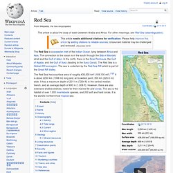
It has a maximum depth of 2211 m (7254 ft) in the central median trench, and an average depth of 490 m (1,608 ft). However, there are also extensive shallow shelves, noted for their marine life and corals. The sea is the habitat of over 1,000 invertebrate species, and 200 soft and hard corals. It is the world's northernmost tropical sea. Extent The International Hydrographic Organization defines the limits of the Red Sea as follows:[3] On the North. WikiMiniAtlas 27°57′N 34°36′E / 27.950°N 34.600°E / 27.950; 34.600) through Tiran Island to the Southwest point thereof and thence Westward on a parallel (27°54'N) to the coast of the Sinaï Peninsula]. On the South. 12°40′N 43°30′E / 12.667°N 43.500°E / 12.667; 43.500) and Ras Siyyan ( Lake Baikal. Lake Baikal (Russian: о́зеро Байка́л, tr.
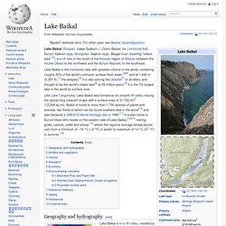
Ozero Baykal, IPA: [ˈozʲɪrə bɐjˈkal]; Buryat: Байгал нуур, Mongolian: Байгал нуур, Baygal nuur, meaning "nature lake";[3]) is a rift lake in the south of the Russian region of Siberia, between the Irkutsk Oblast to the northwest and the Buryat Republic to the southeast. Lake Baikal is the freshwater lake with greatest volume in the world, containing roughly 20% of the world's unfrozen surface fresh water,[4][5] and at 1,642 m (5,387 ft),[1] the deepest.[6] It is also among the clearest[7] of all lakes, and thought to be the world's oldest lake[8] at 25 million years.[9] It is the 7th largest lake in the world by surface area. Like Lake Tanganyika, Lake Baikal was formed as an ancient rift valley, having the typical long crescent shape with a surface area of 31,722 km2 (12,248 sq mi). Geography and hydrography[edit] Baikal's age is estimated at 25–30 million years, making it one of the most ancient lakes in geological history.
Galápagos Islands. The Galápagos Islands (official name: Archipiélago de Colón, other Spanish names: Islas Galápagos, Spanish pronunciation: [ɡaˈlapaɣos]) are an archipelago of volcanic islands distributed on either side of the Equator in the Pacific Ocean, 926 km (575 mi) west of continental Ecuador, of which they are a part.
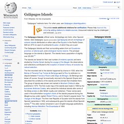
The Galápagos Islands and their surrounding waters form an Ecuadorian province, a national park, and a biological marine reserve. The principal language on the islands is Spanish. The islands have a population of slightly over 25,000.[1] The islands are famed for their vast number of endemic species and were studied by Charles Darwin during the voyage of the Beagle.
His observations and collections contributed to the inception of Darwin's theory of evolution by natural selection. The first recorded visit to the islands happened by chance in 1535, when the Bishop of Panamá Fray Tomás de Berlanga went to Peru to arbitrate in a dispute between Francisco Pizarro and Diego de Almagro. Hydrothermal vent. Physical properties[edit] Hydrothermal vents in the deep ocean typically form along the mid-ocean ridges, such as the East Pacific Rise and the Mid-Atlantic Ridge.
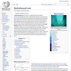
These are locations where two tectonic plates are diverging and new crust is being formed. The water that issues from seafloor hydrothermal vents consists mostly of sea water drawn into the hydrothermal system close to the volcanic edifice through faults and porous sediments or volcanic strata, plus some magmatic water released by the upwelling magma.
Great Barrier Reef. The Great Barrier Reef is the world's largest coral reef system[1][2] composed of over 2,900 individual reefs[3] and 900 islands stretching for over 2,300 kilometres (1,400 mi) over an area of approximately 344,400 square kilometres (133,000 sq mi).[4][5] The reef is located in the Coral Sea, off the coast of Queensland, Australia.
The Great Barrier Reef can be seen from outer space and is the world's biggest single structure made by living organisms.[6] This reef structure is composed of and built by billions of tiny organisms, known as coral polyps.[7] It supports a wide diversity of life and was selected as a World Heritage Site in 1981.[1][2] CNN labeled it one of the seven natural wonders of the world.[8] The Queensland National Trust named it a state icon of Queensland.[9] Belize Barrier Reef. The Belize Barrier Reef is a series of coral reefs straddling the coast of Belize, roughly 300 meters (980 ft) offshore in the north and 40 kilometers (25 mi) in the south within the country limits.
The Belize Barrier Reef is a 300-kilometer (190 mi) long section of the 900-kilometer (560 mi) Mesoamerican Barrier Reef System, which is continuous from Cancún on the north-eastern tip of the Yucatán Peninsula through the Riviera Maya and up to Honduras, making it one of the largest coral reef systems in the world after the Great Barrier Reef in Australia and the New Caledonia Barrier Reef. It is Belize's top tourist destination, popular for scuba diving and snorkeling and attracting almost half of its 260,000 visitors.
It is also vital to the country's fishing industry.[1] Charles Darwin described it as "the most remarkable reef in the West Indies" in 1842. Species[edit] 70 hard coral species36 soft coral species500 species of fishhundreds of invertebrate species Gallery[edit] References[edit] Palau. Palau ( i/pəˈlaʊ/, sometimes spelled Belau or Pelew), officially the Republic of Palau (Palauan: Beluu er a Belau),[4] is an island country located in the western Pacific Ocean.