
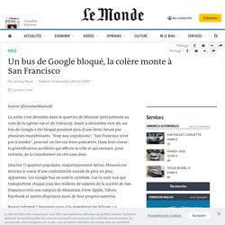
Chinatown San Francisco10 - Chinatown (San Francisco) Un bus de Google bloqué, la colère monte à San Francisco. Suivre @JeromeMarinSF La scène s'est déroulée dans le quartier de Mission (précisément au coin de la 24ème rue et de Valencia): lundi 9 décembre vers 9h, un bus de Google a été bloqué pendant plus d'une demi-heure par plusieurs manifestants.
"Stop aux expulsions", "San Francisco n'est pas à vendre", pouvait-on lire sur leurs pancartes. Dans leur viseur : la gentrification accélérée qui affecte la ville et qui menace, pour certains, de la transformer en cité sans âme. San Francisco. SFDowntownPanoramaFromAlcatraz - San Francisco. The San Francisco Indicator Project. San Francisco, métropole inégale. La question des inégalités a pris une place inédite dans le débat national aux États-Unis ces toutes dernières années : alors que Barack Obama a présenté les inégalités comme « un enjeu essentiel de notre époque » dans son discours sur le « State of the Union » du mois de décembre 2013, le Capital au XXIe siècle (2014) a constitué un succès de librairie retentissant outre-Atlantique et son auteur, l’économiste français Thomas Piketty, y est devenu une véritable star.
Plus largement, près des deux tiers des Etats-Uniens considèrent aujourd’hui que les inégalités sont devenues l’un des défis sociaux les plus importants (Desilver, 2014). Comment mesurer les inégalités socio-économiques ? Port of Oakland. The Port of Oakland is a major container ship facility located in Oakland, California, in the San Francisco Bay.
It was the first major port on the Pacific Coast of the United States to build terminals for container ships. It is now the fifth busiest container port in the United States, behind Long Beach, Los Angeles, Newark, and Savannah.[2] Development of an intermodal container handling system in 2002 culminated over a decade of planning and construction to produce a high volume cargo facility that positions the Port of Oakland for further expansion of the West Coast freight market share. Early history[edit] Originally, the estuary, 500 feet (150 m) wide, had a depth of two feet at mean low tide. In the late 19th century, the Southern Pacific was granted exclusive rights to the port, a decision the city soon came to regret. On May 6, 1915, the Admiral Dewey became the first vessel to dock at the foot of Clay street.
In 1962, the Port of Oakland began to admit container ships. Oakland, California. City in California, United States Oakland's territory covers what was once a mosaic of California coastal terrace prairie, oak woodland, and north coastal scrub.[22] Its land served as a rich resource when its hillside oak and redwood timber were logged to build San Francisco.[22] Oakland's fertile flatland soils helped it become a prolific agricultural region.
In the late 1860s, Oakland was selected as the western terminal of the Transcontinental Railroad.[23] Following the 1906 San Francisco earthquake, many San Francisco citizens moved to Oakland, enlarging the city's population, increasing its housing stock, and improving its infrastructure. It continued to grow in the 20th century with its busy port, shipyards, and a thriving automobile manufacturing industry. History[edit] Pre-incorporation[edit] Development of Chinatown[edit] San Francisco Topography. I made this map several years ago.
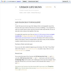
After failing to find a real topographic map of San Francisco that wasn't cluttered with streets, freeways or buildings, I was compelled to make one myself. Meant to show what San Francisco's hills really looks like, the use of atlas style colors enhances the legibility of the map. I've updated the map twice now. Once on March 23, 2012 (as shown below) and more recently the v.2 map in December 2013. The December 2013 map has more labeled peaks and named features on the land. Purchase a Poster and other gear You can see the older unlabeled original map at the bottom.
Related Links You can also find maps of San Francisco with 25 foot sea level rise here and here and with a 200 foot sea level rise here and here.