

Polyglot_openstreetmap. Pakku.io - Magasins de vélos en Ille-et-Vilaine. Pack.master.ille-et-vilaine.shoppsports_bicycle Liste des clés Ces champs sont présents dans ce set de données, en plus de la latitude et de la longitude.
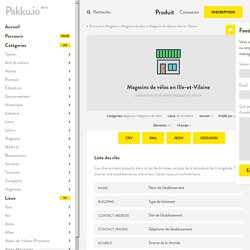
Si vous trouvez une incohérence ou une erreur, laissez nous un commentaire. Tags OSM inclus Ci-dessous, la liste des tags OSM inclus dans le pack. shop~bicycle Répartition Aperçu de la répartition des Magasins de vélos sur le territoire. Matias Dahl. The website matiasdahl.github.io/osm-tag-dynamics is a continuation of the below blog post.
It makes it possible to interactively explore tags related to the top 100 amenity tags. This analysis studies amenities on the OpenStreetMap. These are identified by an amenity-tag that can contain free-form text. Say, amenity=school, amenity=picnic_table or amenity=water_point. Why would you use OpenStreetMap if there is Google Maps? If you’re a GeoGeek, cartographer, developer or you simply need to find a particular place on a map you’ve got two main mapping environments to choose from: Google Maps and OpenStreetMap… and I guess that you might be asking yourself: “Why would I use OpenStreetMap if there is Google Maps?”
There is no ultimate answer as to which one is better. These two have as many similarities as differences. They are based on different fundamentals, but they solve the same basic human need to know “WHERE”. The key difference between these two mapping environments is a philosophic “Open” vs. “Closed” approach with how the data is collected and distributed. FEATURE-Is it a building? Is it a rock? Using technology to chart the 'unmapped world' An aerial view shows a traditional Ethiopian village outside Dolo Ado, near the Ethiopia-Somalia border, August 10, 2011.
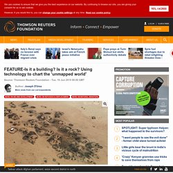
REUTERS/Thomas Mukoya. OSM Compare - Side by Side. Leaflet | Map Data & Map Image © FOSM Contributors.
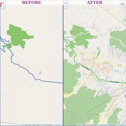
CC BY-SA 2.0. OSM Compare - Side by Side. Bibliothèques de l'université Rennes 2 catalog › Details for: Springer handbook of geographic information. OSM Street View. OpenStreetMap : le prochain projet libre vraiment indispensable, par Glyn Moody. OpenStreetMap vient de fêter souffler sa dixième bougie (et la communauté française vous invite à célébrer cela le lundi 8 septembre à Numa Paris).
Et comme le souligne Glyn Moody dans l’article traduit ci-dessous, on est bien content qu’il soit là parce qu’on ne peut pas compter sur Google pour aborder la cartographie sous l’angle des biens communs… OpenStreetMap: the Next Truly Indispensable Open Project. Last year, I described OpenStreetMap (OSM) as the "open source of maps".
On the occasion of the project's tenth anniversary, I'd like to explore this important example of open collaboration in a little more detail, and explain why I think it is destined to become the next absolutely key open project. First, some history. OpenStreetMap: the Next Truly Indispensable Open Project. Base d'Adresses Nationale Ouverte - BANO. Weekly OSM Metro Extracts. Online army helps map Guinea's Ebola outbreak - 09 April 2014. Health workers responding to an Ebola outbreak in Guinea had no maps to go on, so they turned to the internet for help WHEN doctors working for Médecins Sans Frontières (MSF) arrived in the West African nation of Guinea last month to combat an outbreak of the deadly Ebola haemorrhagic fever, they found themselves working in an information vacuum.
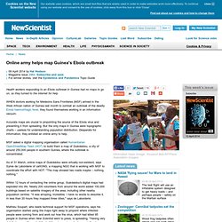
Accurate maps are crucial to pinpointing the source of the Ebola virus and preventing it from spreading. But the only maps in Guinea were topographic charts – useless for understanding population distribution. Desperate for information, they enlisted an online army to help. MSF asked a digital mapping organisation called Humanitarian OpenStreetMap Team (HOT) to build them a map of Guéckédou, a city of around 250,000 people in southern Guinea, where the outbreak is concentrated. Within 12 hours of contacting the online group, Guéckédou's digital maps had exploded into life. The global nature of the mapping effort is stunning, says de Laborderie. Teachosm Info Page. Making the Two-Way Street of Open Data a Reality. Map Give. Quand la communauté OpenStreetMap aide à sauver des vies aux Philippines. Cartopartie Fontenay-Sous-Bois. Research. For OSM school activities, see Education.
From a research perspective, OpenStreetMap is deservedly attracting a lot of attention from universities and similar institutions, and from academic scholars in 'geomatics', 'neogeography', 'volunteered geo-informations'. 'digital cartography', 'participatory geoinformatics' etc. OpenStreetMap is fascinating and vast in terms of scale and variety of the data we offer, the technology we build, and uses we find for the data. But most of all, we are a fascinating and vast community. Whether you're interested in studying the community itself, or working with the datasets, we hope you'll become a part of it and share your knowledge, extend the map, improve existing technologies, and explore new horizons. Introduction To learn more about the project itself, the wiki offers a wealth of (sometimes a little disorganised) information. 9 Years of OpenStreetMap GPS Tracks Available for Mapping. All public GPS tracks ever uploaded to OpenStreetMap are now available for tracing in the iD editor.
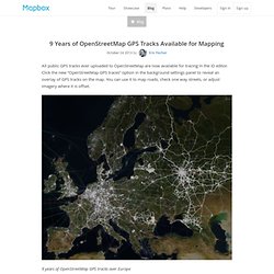
Click the new “OpenStreetMap GPS traces” option in the background settings panel to reveal an overlay of GPS tracks on the map. You can use it to map roads, check one way streets, or adjust imagery where it is offset. 9 years of OpenStreetMap GPS tracks over Europe Local knowledge, satellite and aerial imagery, and GPS traces are the source data from which OpenStreetMap is built. GPS traces play an important role in inferring one ways and turn restrictions, adjusting imagery offsets, and mapping areas where imagery is not available. Untitled. Kort Game. Mobile Web-App to fix OpenStreetMap data.
(play.kort.ch) (open with HTML5 compatible browser) The app uses the concept of gamification to motivate users to regularly use it. This means, that game-like elements are used like winning points and badges to climb the highscore. The points (so called Koins) are collected by the players by fulfilling tasks. Examples of tasks are POIs without a name, where the user has to enter the missing name.
Skill Share: Map Photos Using OpenStreetMap and TileMill. Recently, we organized a fun skill share with Map Kibera, and then again with Transparent Chennai. The idea is to use OpenStreetMap and TileMill to create an interactive photo map of OSM features. Here's the simple result from working with Map Kibera. Want to learn to create something like this? This guide takes four steps, demonstrating an overview of the whole flow and connection between four tools to build a photo map.
This guide will hit the main points, highlight how the tools connect up with open data, and I'll just link to other resources for the details on how to use each. Note, this guide is to create photo maps of objects mapped in OSM, not arbitrary points where you have happened to take photos. What you need: A photo of a place to map.What you get: Link to the photo page and photo preview.Learn more: Flickr Help If you don't have a Flickr account, create one, it's an easy way to share images.
It’s about time – OpenStreetMap Contributor Activity Report 2013 : Neis One! One and a half years ago (end of 2011), one of my open access publications (“Analyzing the Contributor Activity of a Volunteered Geographic Information Project — The Case of OpenStreetMap“) was published. It contained several interesting findings about the contributions made by the community of the OSM project. The results showed that the community follows a particular pattern that many other online community based projects tend to struggle with too.
Harry Wood Blog / Workshop on Using OpenStreetMap Data. I presented a workshop (or at least a live demo session) at the Society Of Cartographers conference with the rather vague open ended title of “Using OpenStreetMap Data” - “A tour of the various options for downloading and otherwise accessing OpenStreetMap data from a geo-data user’s perspective. Harry Wood will explain how to delve into the raw data structures using tools on the website and elsewhere, how to explore the wiki-style editing history, how OpenStreetMap’s unique ‘tags’ approach works, and some ways of manipulating the map data.” At least that’s what I wanted it to be. It didn’t go entirely to plan (see apologies below) Comparison of Volunteered Geographic Information Data Contributions and Community Development for Selected World Regions.
Open AccessThis article isfreely availablere-usable Article 1 Geoinformatics Research Group, Department of Geography, University of Heidelberg, Berliner Street 48, D-69120 Heidelberg, Germany 2 Geomatics Program, University of Florida, 3205 College Avenue, Fort Lauderdale, FL 33314, USA. Program. About OSM PLUS is complementary to the SOTM US conference. Supporting the OpenStreetMap project. Floss Manuals francophone - Lire. « La géographie est une de ces sciences qu’il faudra toujours perfectionner. Quelque peine qu’on ait prise, il n’a pas été possible jusqu’à présent d’avoir une description exacte de la terre. Il faudrait que tous les souverains s’entendissent et se prêtassent des secours mutuels pour ce grand ouvrage. Mais ils se sont presque toujours plus appliqués à ravager le monde qu’à le mesurer [...] Heureusement, on rectifie sur les lieux ce que les géographes ont souvent tracé de fantaisie dans leur cabinet.
CityTracking. Gis at ryerson » Reflections on OpenStreetMap. March 9th, 2013 by Claus Rinner (Claus Rinner's profile) The second Canadian OpenStreetMap (OSM) developer event held at Ryerson’s Geography department started today with a series of presentations and workshops introducing students and members of the broader community to OSM. Open Street Map Reporter. Open Street Map Was Faster In Mapping North Korea Than Google Maps. Home / Maps / Open Street Map Was Faster In Mapping North Korea Than Google Maps Couple of days ago I wrote a post about Google maps of North Korea.
Numérique - Article - Google Maps versus OpenStreetMap : redistribution des cartes sur le Web ? Muki HAKLAY, Alex SINGLETON, Chris PARKER « Web Mapping 2.0: The Neogeography of the GeoWeb » Geography Compass, Vol. 2 n°6, 2008, pp. 2011-2039. Rich GIBSON, Schuyler ERLE, Google Maps Hacks. Revue-espaces-article-becquet-jean-christophe-openstreetmap-cree-des-donnees-libres-pour-le-territoire-le-projet-dessine-ta-ville.pdf (Objet application/pdf) OpenStreetMap: Indispensable People?
Bienvenue sur le site OpenStreetMap France ! Major project to improve accessibility to OpenStreetMap data initiated. Open data et numérique au service d’une démocratie plus citoyenne. OpenStreetMap live edits - live.openstreetmap.fr. Floss Manuals francophone - Lire. Correction OSM Lima sept2012. Error OSM Lima mai2012. Interview de Gaël Musquet, président d’OpenStreetMap France.
OpenStreetMap. Worst of OSM. Remapping. Geofabrik Tools.
Key:seamark:type. 3D buildings from OpenStreetMap in OpenWebGlobe. Using OpenStreetMap Data with Open-Source GIS. Introducing “map gardening”