
Earth geological and climatic history. Coordenadas geográficas. Unitat didàctica 1. Mapes - Jocs de localització a mapes. Observatori del Paisatge. El mapa dels paisatges L'elaboració per part de l'Observatori del Paisatge dels catàlegs de paisatge ha permès obtenir el mapa de les unitats de paisatge de Catalunya.
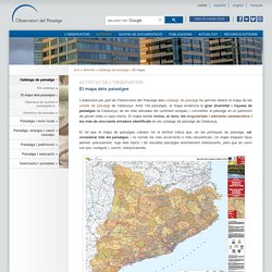
Amb 134 paisatges, el mapa evidencia la gran diversitat i riquesa de paisatges de Catalunya, de les més elevades del continent europeu, i converteix el paisatge en un patrimoni de primer ordre a casa nostra. El mapa també inclou, al dors, les singularitats i elements característics i els més de cinc-cents miradors identificats en els catàlegs de paisatge de Catalunya. El fet que el mapa de paisatges cobreixi tot el territori indica que, en les polítiques de paisatge, cal considerar tots els paisatges, i no només els més excel·lents o més naturalitzats. Un mapa d'aquest tipus permet, precisament, fugir dels tòpics i fer ressaltar paisatges enormement interessants, però que en canvi són poc coneguts i, sovint, menysvalorats. L'emoció pintada. El paisatge romàntic Painted emotions.
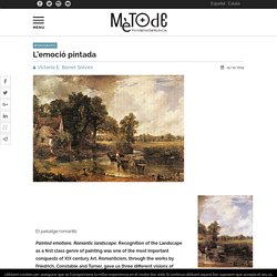
Romantic landscape. Recognition of the Landscape as a first class genre of painting was one of the most important conquests of XIX century Art. Romanticism, through the works by Friedrich, Constable and Turner, gave us three different visions of nature, its perception and overall the expression of those emotions it can inspire. Climes i paisatges de la Terra ACTIVITATS Unitat 3 Activitats extretes de la presentació Climes i paisatges de la Terra de Salvador Vila Esteve. MODELS D EXÀMENS PRIMER C Examen Carolina, Raimon, Mario 1-.
Types of Weathering - Pass My Exams. What is Weathering?
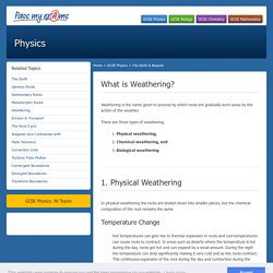
Weathering is the name given to process by which rocks are gradually worn away by the action of the weather. There are three types of weathering. Physical weathering, Chemical weathering, and Biological weathering 1. Physical Weathering In physical weathering the rocks are broken down into smaller pieces, but the chemical composition of the rock remains the same. El sencillo experimento que demuestra el brutal efecto de la deforestación en las inundaciones. El 'Día de la Sobrecapacidad de la Tierra' es el momento en el que el planeta ha agotado el 'presupuesto ecológico' de la Tierra para el 2018.
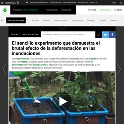
Esto indica que la demanda de recursos naturales de la humanidad ha superado lo que los ecosistemas pueden renovar este año, según los datos de la organización científica Global Footprint Network ofrecidos por WWF. En el caso de España, el país entró en déficit ecológico el 11 de junio de 2018. Por ello, apunta que si todos los seres humanos viviesen como un español medio, consumirían el equivalente a 2,3 planetas por año. Qué es la erosión del suelo: causas y consecuencias. Shaped by Time. Google Earth/KML Files. Plegamientos geológicos – simulation, animation. Tectonic Plates, Earthquakes, and Volcanoes. Dinámica interna de la Tierra. Les formes de relleu terrestre. Zones climàtiques (biología - 6º primaria - clima) Geography from Mrs. Oz. Updated August 2010 Looking at the Earth The Five Themes - Latitude/Longitude - Maps - Map Projections Five Themes of Geography - An Overview of the Five Themes of Geography The Five Themes of Geography 5 Themes of Geography - Definitions USGS Education Greenwich Meridian: Prime Meridian of the World - Zero degrees Longitude The Equator, Hemispheres, Tropic of Cancer, and Tropic of Capricorn - Geography geocoder.us: a free US address geocoder - type in your address and get the coordinates!
What's It Like Where You Live? Blue Planet Biomes - Tundra Biome. Did you know that the Arctic Tundra is the world's youngest biome?
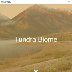
It was formed 10,000 years ago. Located at latitudes 55° to 70° North, the tundra is a vast and treeless land which covers about 20% of the Earth's surface, circumnavigating the North pole. It is usually very cold, and the land is pretty stark. Almost all tundras are located in the Northern Hemisphere. Small tundra-like areas do exist in Antarctica in the Southern Hemisphere, but because it is much colder than the Arctic, the ground is always covered with snow and ice. Tundra comes from the Finnish word "tunturia", which means a barren land. The main seasons are winter and summer. The Arctic tundra is also a windy place and winds can blow between 30 to 60 miles (48 to 97 kilometers) per hour. The tundra is basically like a desert when it comes to precipitation.
There is barely any vegetation in the tundra, only about 1,700 different species, which isn't very much. Surprisingly there are animals in the tundra. The Climate Zones World Map. Internet Geography - Activities. Interactive Climate Map. Move cursor over rectangle to reveal climograph.
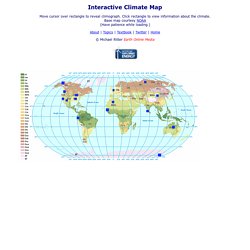
Click rectangle to view information about the climate. Interactive World Climate Map with Climate Graphs. Efecte hivernacle. Fitxes. Meteo comarques. Documental El reino vegetal: 2- Los secretos del reino vegetal online. Relacionar Les fonts de la història. historia. montserrat alsi... Latest Earthquakes. Climograma de Sonnblick (Austria) Dying Coral Reefs Impact Environment and Economy. An underwater investigation of coral bleaching in the South Pacific By Justin Worland | Photographs by XL Catlin Seaview Survey Richard Vevers has traveled the globe to photograph coral reefs since quitting his advertising job.
In 2011 he cofounded the XL Catlin Seaview Survey, a collaboration between the University of Queensland and a number of research institutions, photographing underwater corals as they adapt to climate change. He captured the Great Barrier Reef during its latest—and most devastating—mass die-off, and documented how coral off the coast of Belize had partially recovered thanks to a no-fishing zone. But no dive has stunned Vevers as much as the sight of corals going white during an early March dive in the New Caledonia Barrier Reef, located about 1,000 miles from Australia’s better-known Great Barrier Reef.
Coral die-offs—caused by a process known as bleaching—tend to look as bland and lifeless, in contrast to the vibrant rainbow colors of thriving coral. Maps & Data. Map Tunnelling Tool. Tunnel to the Other Side of the Earth Have you ever wondered which part of the other side of the earth is directly below you?
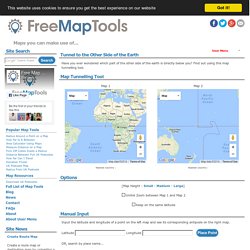
Find out using this map tunnelling tool. Map Tunnelling Tool Options Unlink Zoom between Map 1 and Map 2 Keep on the same latitude Manual Input Input the latitude and longitude of a point on the left map and see its corresponding antipode on the right map. Paisatges - Ara.cat. Socials. Planeta en mapes. Eina que permet trobar l'altitud d'un lloc. La longitud i la latitud. Els fusos horaris. Geo-Names permet localitzar un lloc a partir del codi postal i saber-ne les coordenades. Les coordenades geogràfiques: paral·les, meridians, ... Coordenades. Paisatge mediterrani. ClimaTIC. Estrats i plegaments. Geografia y Medio Ambiente.
Taller de ciències socials. SEASON SWF: Download, open and convert a .swf season file for free! Tempsclima2. ARA Mirades - Ara.cat. Mawson station – Antarctic webcam. El comentari d'una fotografia. Els principals climes del món.