
MapMaker Page Maps. Exploration and Discovery Home Page. The Discovery and Exploration collection has been migrated to an improved presentation.
Please visit the new presentation. The mission of the Library of Congress is to make its resources available and useful to Congress and the American people and to sustain and preserve a universal collection of knowledge and creativity for future generations. The goal of the Library's National Digital Library Program is to offer broad public access to a wide range of historical and cultural documents as a contribution to education and lifelong learning. History of cartography. The Fra Mauro map, one great medieval European map, was made around 1450 by the Venetian monk Fra Mauro.
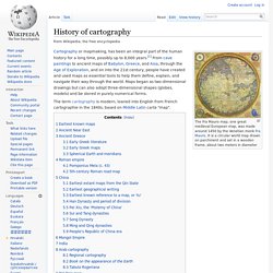
It is a circular world map drawn on parchment and set in a wooden frame, about two meters in diameter Cartography or mapmaking, has been an integral part of the human history for a long time, possibly up to 8,000 years.[1] From cave paintings to ancient maps of Babylon, Greece, and Asia, through the Age of Exploration, and on into the 21st century, people have created and used maps as essential tools to help them define, explain, and navigate their way through the world. Maps began as two-dimensional drawings but can also adopt three-dimensional shapes (globes, models) and be stored in purely numerical forms. The term cartography is modern, loaned into English from French cartographie in the 1840s, based on Middle Latin carta "map". Earliest known maps[edit] The earliest known maps are of the heavens, not the earth. Ancient Near East[edit] Tools Used by Early Explorers. Around the 10th century A.D., the sandglass, or hourglass, was invented to mark the passage of hours.
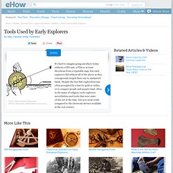
Early explorers, especially those at sea, needed to mark not only the length of their watches, but also the time it took to reel in and out the rope attached to the chip log. Sandglasses, most often filled with pulverized shells, marble or rocks instead of sand to avoid clumping, measured different increments of time, usually an hour, but 30-second sandglasses were also needed for timing the chip-log.
World Exploration Map, Early Voyages by Maps.com from Maps.com. Www.davidcolarusso.com/handouts/quadrant.pdf. Activities for Students and Teachers. The Teacher Guide and Student Activities in this section were created as a resource of ideas.
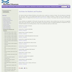
You are welcome to download and copy them. Many of the activities stand alone but some are created to enhance a section of text. The puzzles in the student section are adapted from the Biographies and Vocabulary sections. The answer keys are located in the Teacher section. These activities are adaptable for fifth grade through high school students.
Activity One: Create a Compassteachers | students Activity Two: Create an Astrolabeteachers | students Activity Three: Create a Quadrantteachers | students Activity Four: Identify Navigational Instrumentsteachers | students Activity Five: Identify the Parts of a Shipteachers | students Activity Six: What Would You Take to Sea? Activity Seven: Biography Crossword Puzzleteachers | students Activity Eight: Vocabulary Word Searchteachers | students Activity Nine: Create a Globeteachers | students. Oceanservice.noaa.gov/education/for_fun/MakeyourownCompass.pdf. 07 Making a Simple Astrolabe - At Home Astronomy. Explorers, Vikings, English, Conquistadors - Kids Online Resources. Explorers of North America. Juan de Oñate y Salazar (1550?
-1626) was a Spanish conquistador who established the colony of New Mexico for Spain and became New Mexico's first governor. Oñate, the son of a conquistador who made a fortune in silver, was married to a granddaughter of Hernán Cortés. In 1595, Oñate requested that he be sent to conquer and rule New Mexico, search for treasure (especially the legendary silver treasure of Quivira), and bring Christianity to the local Indians. After governmental approval, Oñate left for New Mexico in January, 1598, with 400 settlers and soldiers (and their livestock).
In July 1598, the expedition crossed the Rio Grande at El Paso. In 1601, Oñate led an expedition to the Great Plains of America that tried, unsuccessfully, to find the legendary silver of Quivira (thought to be in what is now central Kansas, east of Salina). Go to a printable read-and-answer worksheet on Onate. Famous Explorer Biographies. Explorers-in-Residence from National Geographic: Highlights some of the world of today's prominent explorers and scientists.
Famous Space Explorers: Quick facts, photos, and information about their space exploration National Geographic: Explorers A-Z: Explorers are listed in alphabetical order with a links to websites with facts about each explorer Explorers-EnchantedLearning.com: Brief biographical information on famous explorers; Search alphabetically or by date or continent. Exploration of North America, 1492-1700. MapMaker Interactive. Untitled.